Curated OER
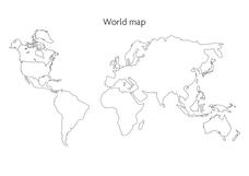
World Map
In this social studies worksheet, students use the unlabeled world map for any geography activity. The individual countries are not marked with border lines.
NOAA
A Watery World
With about 70% of the earth's surface covered in oceans, it's fair to say that we live in a very wet world. Young scientists gain a better appreciation of this fact as they use maps to identify the world's ocean basins in the first...
Curated OER
NATO Geography & Language
The class receives background information on NATO, an atlas, and a blank world map. They color the original 1949 countries in red, the 1952 additions in green, and the 1990 additions in blue. This exercise would be a good starting point...
Curated OER
Where in the World Is Mexico?
Students practice map-reading skills as they locate Mexico and its cities on a world map. By creating a puzzle out of a map of Mexico, students engage in a meaningful hands-on activity to help them explore that country's geography.
California Academy of Science
California's Climate
The United States is a large country with many different climates. Graph and analyze temperature and rainfall data for Sacramento and Washington DC as you teach your class about the characteristics of Mediterranean climates. Discuss the...
Curated OER
World Religions
Ninth graders investigate the symbols and historical figures of the five main religions of the world. They participate in a class discussion, listen to a lecture and take notes, and write five Haikus, one about each major religion of...
Council for Economic Education
China - Where Will They Fit in the World Economy?
Teach scholars why China is so crucial to global economics through an informative resource. Activities include using databases to search for information, watching a video or listening to a podcast, and reading about China's economy as a...
Curated OER
A world of oil
Students practice in analyzing spatial data in maps and graphic presentations while studying the distribution of fossil fuel resources. They study, analyze, and map the distribution of fossil fuels on blank maps. Students discuss gas...
NOAA
Into the Deep
Take young scientists into the depths of the world's ocean with the second lesson of this three-part earth science series. After first drawing pictures representing how they imagine the bottom of the ocean to appear, students investigate...
NY Learns
Geography of the Fertile Crescent by ECSDM
Using Google Earth, a vocabulary assignment, and map handout, your class members will outline the Fertile Crescent in Mesopotamia and identify the source of the Tigris and Euphrates rivers. They will then complete graphic organizers...
Curated OER
Jamestown Celebrates 400th Anniversary
Students view a world map and identify the locations of England and Virginia and discuss what kinds of things they would take with them on this kind of trip. They read the words in the news box on the student page and fill in the blanks...
Curated OER
Geography: Mapping Newspaper Coverage
Students examine the locations of stories appearing in newspapers and determine where to assign reporters. Using various maps, they connect the stories to the correct maps and create charts of the story locations. Students explain their...
Curated OER
Where In the World Are You?
Fourth graders fill in blank copies of the United States Map and then the World Map.
Curated OER
World Oceans
Students locate the world's oceans. In this geography skills lesson plan, students chart the locations of the Indian, Arctic, Pacific, and Atlantic Oceans on world maps.
Curated OER
Around the World in 5 Days
Learners explore continents, draw map, discuss cultures, use research to learn geography, and investigate cultures.
Curated OER
The Race to Dominate the Known World
Young scholars describe cause/effect relationship of a European country's need for resources, exploration, colonization, and settlement of different regions of the world beginning in the 14th Century, and role play representatives of...
Curated OER
World Religions
Seventh graders identify major tenets and the distributions of world religions. In this world religions lesson, 7th graders work with a group to research a religion using the given website. Students complete a graphic organizer for the...
Curated OER
Environment: How'd That Pollution Get There?
Students examine how global wind and water patterns aid in the spread of worldwide pollution. In groups, they read articles about the domino effect of pollution and create posters displaying its journey. On blank world maps, students...
Peace Corps
Celebrating Our Connections Through Water
Water is vital for survival, but how does it help global cultures flourish? Elementary and middle schoolers learn about the different cultures around the world that celebrate water and incorporate it into their festivals or traditions.
Curated OER
Roman Empire: Physical Framework - Location, Borders, Dimensions
Learners relate the classical world to the modern world. In this map skills lesson, students turn a blank map into a colorful complete map by following step-by-step directions. This lesson allows learners to connect our current geography...
Curated OER
Explorer Comprehension Worksheet
In this exploration worksheet, students draw the routes of the listed explorers on the blank world map. Students should also provide a color-coded map key.
Curated OER
Religions of the World
Second graders explore the part that religion plays in a culture. They explore how many different religions there are in the world and where they're located.
Curated OER
Where in the World Do Those Cookies Come From?
Students discuss exports and imports by discovering where the ingredients come from for making chocolate chip cookies. They take a survey of their favorite cookies and create a bar graph to represent the information.
Scholastic
Perfect Postcards: Illinois
Connect the geography and history of Illinois using an art-centered lesson plan on the railroads. The railroad connected once-distant places, particularly in the Midwest. Using research, class members create postcards of fictional...
Other popular searches
- Blank Maps of World
- Blank World Outline Maps
- Blank Map of the World
- Blank Map of World
- Blank Maps of the World
- Blank World Political Map
- World Physical Map Blank


