Public Schools of North Carolina
Democratic Republic of Congo - Map Skills
Work on your map skills with a packet of activities about the river basins in the Democratic Republic on Congo. Learners study the maps provided before answering the geography questions and writing an acrostic poem about the region.
Parkwood Hill Intermediate
Map Skills Project
Young pupils develop their mapping skills and knowledge by designing their own islands, using geographic terms and physical features they have learned as features of their work.
Alabama Department of Archives and History
La Mobile: A Case Study of Exploration and Settlement
The Le Moyne brothers, Jean-Baptiste and Pierre, were among the first explorers of the Gulf Coast. Class members read biographical information and journal entries about these men, study maps showing where the settlements they established...
Curated OER
Greeks Around the World: A Case Study on Greek Diaspora
Students gain an understanding of the concept of Diaspora relating to Greeks. They use guided discovery to apply the geographic inquiry model to an examination of the reasons for Greek Diaspora.
National Geographic
Mapping the Americas
Celebrate the geography of the Americas and develop map skills through a series of activities focused on the Western Hemisphere. Learners study everything from earthquakes and volcanoes of the Americas and the relationship between...
Richmond Community Schools
Map Skills
Young geographers will need to use a variety of map skills to complete the tasks required on this worksheet. Examples of activities include using references to label a map of Mexico, identify Canadian territories and European countries,...
National Geographic
Exploring Modern Human Migrations
Using maps, images, websites, and handouts, learners work to understand the nature of human migrations. They compare and contrast human migration from the past to the present, identify causes for migration, and trace migration routes on...
Teach Engineering
What is GIS?
Is GIS the real manifestation of Harry Potter's Marauders Map? Introduce your class to the history of geographic information systems (GIS), the technology that allows for easy use of spatial information, with a resource that teaches...
Curated OER
Analyzing Hurricanes Using Web and Desktop GIS
High schoolers analyze hurricanes. In hurricanes instructional activity, students use the Internet and GIS to analyze hurricanes. High schoolers view the National Atlas of Maps to discuss the direction hurricanes move. Students study the...
Curated OER
Baseball Challenge - Basic Geography Skills
A fabulous presentation/activity based on geography. The author has designed a "baseball game" where batters advance to the next base if they correctly answer a multiple choice question about geography. Geographic terms are used, along...
Curated OER
Using GLOBE Data to Study the Earth System (College Level)
Students use the GLOBE Website to locate and study environmental data. They use the GLOBE Graphing Tool to display data. Students describe the role of solar energy in the annual fluctuations of soil moisture. They describe reservoirs and...
Society for Science & the Public
Easter Islanders Made Tools, Not War
When studying artifacts, especially tools, how do archaeologists determine what the devices were used for? In what ways might researchers' previous experiences influence their perception of an artifact? An article about researchers'...
Owl Teacher
Introduction to World Geography
Give your learners a thorough overview of what they will learn when studying geography, from the five themes of geography (location, place, environment, movement, and regions) to the tools of a geographer and parts of a map.
Curated OER
The Inuit Family: A study of its history, beliefs, and images
Students study the Inuit in terms of their geographic location and its influence on their way of life. They investigate Inuit imagery as a reflection of their belief system and focus on the objects of the Inuit to introduce...
Curated OER
Crowley's Ridge: An Upland in the Lowlands
Young geographers examine how Crowley's Ridge was formed. This is one Arkansa's six natural geologic divisions. The history of Crowley's Ridge is important in that the first settlers of the state were attracted to this region, and it...
Curated OER
Bearing the Torch: A Study of Ancient Greece
Second graders research Ancient Greece. In this Ancient Greece lesson, 2nd graders survey the geographical, historical, and cultural aspects of Greece. Students discover stories of Greek mythology and explore the beginning of the Olympic...
Curated OER
Finding Meaning in the Badge
Children who are three to five years old study two rank badges from the Qing dynasty to develop an understanding of social rank, language skills, and symbolism. The lesson is discussion-based and requires learners to compare and contrast...
Curated OER
Water Quality and Watersheds: A GIS Investigation
Requiring more than one class period, this resource takes earth science learners on a journey through a watershed. Using ArcGIS Explorer, an online geographic information system, they view maps of watersheds and surrounding landscapes....
Center for History and New Media
A Look at Virginians During Reconstruction, 1865-1877
The transition between rebellion to reunification was not smooth after the Civil War. Young historians compare primary and secondary source documents in a study of the Reconstruction era in Virginia, noting the rights that were not...
Curated OER
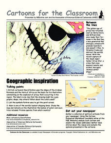
Cartoons for the Classroom: Geographic Inspiration
A wonderfully graphic cartoon entices learners to read more about issues near the Arabian Peninsula. They will use the provided cartoon and critical thinking question to practice building their analytical and critical thinking skills....
Oxford University Press
Language Focus and Vocabulary Unit 4.1: Past Continuous and Prepositions
Study verb tense, prepositions, and geographical features from around the word in one activity. After choosing between was and were in several sentences, as well as deciding whether they should use the past tense or past continuous...
World History Digital Education Foundation, Inc.
COVID-19: Geographic Diffusion
An intriguing instructional activity provides information to help academics understand the role of geography in the diffusion of the COVID-19 illness. Academics interpret charts and make predictions for the future. The timely resource...
Curated OER
Do the Tallywalker
Students study the basics of mapmaking, then make a tally walker, (geographic location device used in secret).
Just Health Action
Environmental Justice Matters: Mapping Cumulative Impacts (Part 2)
A case study enables class members to confirm whether different geographic parts of Seattle, Washington have disproportionate environmental burdens and benefits. Groups use the EPA's Cumulative Health Impact Analysis formula and...


