EngageNY
Determining Main Idea Using Text and Illustrations: Accessing Books Around the World
Ease into informational text with the lesson suggested here. Part of a unit series, the lesson draws from previous lessons and acts as a natural moment to add in informational text. Class members read one section of My Librarian is a...
Curated OER
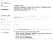
Theme Map- The Rainforest
Young scholars use graphic organizers to relate information. They read an article and insert information from the article to the theme map using a word processing program.
Curated OER
Learning about Maps and Colors
First graders discuss "Harold and the Purple Crayon" and his drawings. In this neighborhood geography activity, 1st graders learn to detect and classify places on a map including their home. Students recognize their address as a specific...
Curated OER
MAPS AND TOPOGRAPHY
Students analyze the details of a topographic map and create one of their own by utilyzing a map of elevations.
Curated OER
Mapping an Empire
How did the expansion of the Roman Empire during the first century contribute to its downfall? Using a map of the Roman Empire in 44 BC and one of the Roman Empire in 116 AD as references, class member use critical reading skills to...
Curated OER
Drawing a "Life Map"
Students create an autobiography. In this writing lesson, students use a life map as a graphic organizer to develop their autobiography.
Curated OER
Map Your State: Regions of Arizona
Fourth graders define vocabulary and locate physical features on maps. In this mapping instructional activity, 4th graders explore regions of Arizona through landforms found on topographic maps. Students research the history...
Curated OER
Me on the Map Lesson 2
Students analyze and interpret maps, globes and geographic information systems to define and identify cities, counties, states, countries and continents to create a booklet called me on the map. They also determine and calculate the...
Curated OER
Mapping the Human Movement
Students research data on African-American emigration, place the data in a chart and create a human movement map. They also create another map using research on current immigration information.
Curated OER
Map It Out
Third graders create obstacle course maps. They lay out their course on the playground, using symbols for trees, fences, etc, Students, in groups, exchange maps and then follow the courses.
Curated OER
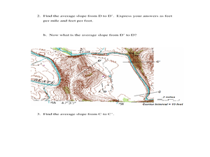
Slope and Topographic Maps
Students investigate slopes as they study topographic maps. In this algebra instructional activity, students discuss and apply the concept of slopes to graphing and analyzing data.
Curated OER
Reading Comprehension
In this reading comprehension lesson, 3rd graders read the story Treasury of Literature and complete various comprehension activities. Students answer factual questions about the story, analyze the story using a bubble map, and...
Curated OER
Intermediate Guided Reading Lesson Plan
Third graders read Children of the Earth and Sky: Five Stories about Native American Children by Stephen Krensky. In this guided reading instructional activity, 3rd graders gain knowledge about various Native American tribes. Using a...
Curated OER
Weather Forecasting
Learners discover how to read a current weather map. In this weather forecasting lesson plan, students view weather maps from three consecutive days and observe how quickly weather moves and changes. Learners review key terms associated...
Curated OER
Idea Mapping
Students generate, share and display ideas as a group. They break into small groups to work on hand-drawn maps made up of concentric circles. they come before the group and make a similar diagram by charting each other's characteristics.
Curated OER
Poverty Point Native Americans
Students investigate the Poverty Point Indians. In this Native Americans lesson, students research the Indians and use the information to fill out graphic organizers and to compare and contrast communities over time. Students locate...
Core Knowledge Foundation
Columbus Sailed the Ocean Blue
Young adventurers embark on a journey, setting sail along the blue ocean with Christopher Columbus. Teachers will find that this unit makes their lesson planning smooth sailing!
Curated OER
Create a Math Road Trip
Young scholars create a Road Trip. They work in small groups. Students are given a road map for each group. They plan a road trip between two cities on opposite edges of the map, estimating a reasonable distance to travel each day. Young...
Curated OER
Condon National Bank
Use maps, readings, and photographs to analyze the historic, cultural, and social conditions surrounding the activities of the Dalton brothers and their gang. Learners identify how the residents of Coffeyville defended themselves against...
Curated OER
Mapping Your Neighborhood
Students use atlases, maps, and Web resources to generate and examine maps of their own neighborhoods.
Curated OER
Mapping It Out
Fourth graders examine various aspects of the environment of Utah. In groups, they create four maps of Utah, based on temperature, precipitation and elevation. To end the activity, they are asked a question as a group and use their...
Curated OER
Map It!
Fourth graders collect and explore different maps and their uses before using the program Pixie to create maps of geographic features, political features, and economic information for the state in which they live.
Curated OER
Mapping the Local Community
Students review the symbols and legends of a map. In groups, they follow a set of directions to create a map showing the route to a specific place. They present their map to the class and review the basic components of a community.
Curated OER
The O Zone-Code Read Alert
What are the effects of an air quality alert? Expert groups receive one component of air quality information resources to study. Pupils then jigsaw into new groups and share their knowledge. Finally, they draft a statement of what they...
Other popular searches
- Map Reading Skills
- Earth Science Map Reading
- Esl Map Reading
- Map Reading Activities
- Reading a Map
- Basic Map Reading
- Map Reading Powerpoint
- Topographic Map Reading
- Map Reading Grade 6
- Lessons on Map Reading
- Elements of Map Reading
- Geography Map Reading Skills
