California Academy of Science
California's Climate
The United States is a large country with many different climates. Graph and analyze temperature and rainfall data for Sacramento and Washington DC as you teach your class about the characteristics of Mediterranean climates. Discuss the...
Curated OER
California Geography
Fourth graders explore geography of four distinct regions of California: mountains, coast, central valley, and desert. They locate California on map, identify state's boundaries and borders, and explore agriculture, a major economic...
Curated OER
Geography Journey
Fourth graders examine the geographic features that define places and regions and answer questions about the state of California. They discuss the components of a map legend and answer worksheet questions using a map of California as a...
Curated OER
US Geography: The Midwest
Learners investigate the geography and agricultural products of the Midwestern United States. In this US geography lesson, students watch and discuss a video that depicts the Midwest of the US as the breadbasket of the country. They make...
Curated OER
Exploring California's Regions
Students participate in small groups to create a California's Region map. They research and identify the climate, geographic features, and one or two special features of their assigned region.
Curated OER
Where in California is Amelia?
Students find Amelia somewhere in California. In this geography lesson plan, students learn about the regions of the state where different crops grow and see how they are produced with the help of many families like Amelia’s
Curated OER
Geography: Intro to Canada
Students investigate the geography of Canada by analyzing a map of the country. In this North American geography lesson, students identify the 13 provinces of Canada and their locations by examining a Canadian map. Students may use...
Curated OER
Regional Landforms and Native People
Third graders study the Native American tribes of Maidu and Miwok by studying Internet artifacts, culture, language, music, storytelling, architecture, food, clothing, crafts and geology.
Curated OER
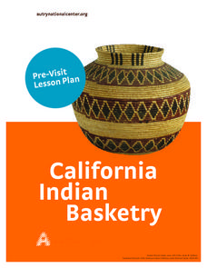
California Native American Basket Weaving
Fourth graders consider the role that baskets play in the traditional lives of Native Americans in California. Students investigate types of baskets and their various uses and then weave their own baskets.
Global Oneness Project
Citizen Photojournalism
Matt Black's photo essay, "The Geography of Poverty" provides a shocking reminder of the poverty that exists in the United States. The resource not only focuses attention on poverty but also conditions that have given rise to situation...
Curated OER
Geography: Why Is the Sacremento Valley a Good Place to Grow Rice?
Third graders locate the Sacramento Valley in California where rice is grown. In this rice growing location lesson, 3rd graders locate the Sacremento Valley, California on a map, and color the mountain ranges and terrain that is around...
Curated OER
U.S. Geography: The Midwest
Students research agricultural products of the Midwest. For this Midwest lesson, students watch a video about the geography of the Midwest, discuss how topographical features were formed and review the agricultural products the Midwest...
Curated OER
VAcations in Northern California
Students explore the natural resources and National Parks of Northern California that are commonly visited by people traveling in the United States. They use maps to locate various sites, plan a highway travel route and use the internet...
Curated OER
My Summer Vacation
Students study the United States geography using Google Earth. In this U.S. geography lesson, students create travel journals about five U.S. geographical locations. Students research the human and physical characteristics for each region.
Curated OER
Geography and Its Impact on Colonial Life
Young scholars interpret historical evidence presented in primary and secondary resources. In this colonial America lesson, students conduct research to determine how geographic conditions dictated settlement...
Curated OER
Postcards from California: A Unit on Geography, Social Studies, History and California's Resources
Fourth graders examine patterns that influence population density in the various regions of California. The unit's three lessons utilize graphic organizers for the interpretation and presentation of data.
Curated OER
How Big is Big?
Geography learners compare and contrast population densities throughout the world. Using maps, they estimate the relative size of the world's regions and populations. They develop analogies to discover the world they live in and...
Curated OER
The Great Depression and Everyday Life
Examine everyday life during the Great Depression, as well as the effects if the Depression on American population, society, and economy. Learners write who, what, where, when, and why summaries of a person who relocated to California...
Curated OER
Growth of a City
Learners evaluate aerial photographs of Beverly Hills taken in 1923 and 1932, and examine the effects of rapid growth of a region. They discuss the needs of city planning, compare the two photographs, and answer discussion questions.
Curated OER
Not Just Another Native American Lesson
Second graders focus on Native Americans through hands-on crafts. They also study various Native American tales and legends, geography, and fine arts of the different regions.
Curated OER
Medieval African Kingdoms
Seventh graders examine the geography and political history of West Africa. They role-play as applicants to a company that transports customers to any historic time period. Working in teams, they create promotional products encouraging...
Curated OER
Diversity
Students work in groups to research and prepare an oral report about a region. In this regions lesson plan, students find out about the geography, population, state capitals, and landmarks. Students assign attributes to the people...
Curated OER
Tectonic Plates, Earthquakes, and Volcanoes
Challenge geography classes to locate the major volcanoes and earthquake faults on a world map. In groups, they identify the pattern made and examine the relationship between the locations of the faults and volcanoes and tectonic plates....
Curated OER
Where Does It Come from?
Learners read articles about various agricultural products and create a map using the statistics in the article. In this agricultural statistics lesson, students look at the geography of the country and which products come from the...


