Curated OER
Great Lakes Homepage for Kids
Here are some outstanding lessons on the geology and history of the Great Lakes. These lessons are divided into Grade 4 -6, and Grade 7 - 8 activities. The activities all use the background information, maps, graphs, data, and Great...
Curated OER
The Great Lakes
In this Great Lakes worksheet, students observe the Great Lakes location on a partial U.S. map, write their names in the acronym HOMES, list them in order from largest to smallest, and identify states that border them. Students write...
Curated OER
How to Make a Lake
Delve in the creation of the Great Lakes in Michigan. After listening to stories about the formation of the lakes in this area, pupils perform experiments to investigate how this occurred. This provides a great way for learners to...
Curated OER
The Great Lakes
In this Great Lakes geography worksheet, students identify Lakes Superior, Huron, Michigan, Erie, and Ontario on a map. Students also practice writing the lakes names in cursive and respond to 2 short answer questions.
Curated OER
Great Lakes at Stake
Students explore conservation of the Great Lakes. For this geography and ecology lesson, students identify the Great Lakes on a map and view a video depicting the history and importance of these lakes. Students work in groups to research...
Curated OER
Introducing Industries
If you are looking for a way to explore Michigan's resources, physical features, and more, this lesson is for you. After discussing Michigan and the Great Lakes, learners fill out a graphic organizer identifying the state's natural...
Curated OER
Great Lakes Cities Quiz
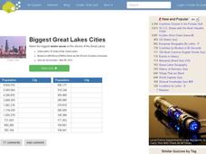
In this online interactive geography worksheet, students examine a map of the Great Lakes region and identify the 20 noted cities on the map using a pull down menu within 4 minutes.
Curated OER
What Do Maps Show?
This teaching packet is for grades five through eight, and it is organized around geographic themes: location, place, relationships, movement, and regions. There are four full lessons that are complete with posters, weblinks, and...
Curated OER
These Lakes are Great
Young scholars examine the Great Lakes Basin and water conservation. In this Great Lakes and water activity, students study the location of the lakes before reading the book, The River Ran Wild. They discuss the associated vocabulary and...
Curated OER
United States Map - Lesson 11
Students explore lakes of the United States. In this geography lesson plan, students identify noteworthy lakes on a map of the United States.
Curated OER
Colonial North America
Showcase the religion, conflicts, daily life, and politics of Colonial North America. A very well-done presentation highlights all the major colonial groups, social norms, demographics, and political struggles of the time. Perfect for an...
Curated OER
North Carolina Salt Dough Map Social Studies Project
In this lesson plan, North Carolina Salt Dough Map, 4th graders create a salt dough map of North Carolina, Students use dough to form the shape of the state of North Carolina. Students label the three regions of North Carolina and all...
Curated OER
Introduction to the United States Map
Students identify a map of the United States. In this United States map instructional activity, students study a map of the United States and find various locations on the map. Students then locate and list the state that touches their...
Curated OER
Maps Can Help Us
First graders explore the geography of Montana by analyzing geographic maps of the area. In this Native American reservation lesson, 1st graders discuss the similarities and differences between reservations in the state of Montana....
Curated OER
Introduction to the United States Map
Students explore the United States using a map. In this map lesson, students discover how to use a United States map and a globe to locate places.
Curated OER
Map Keys
Third graders examine maps and map keys. In this locating map features lesson, 3rd graders use crayons, markers and colored pencils to label maps. Students work in partners to read map keys and locate given places and things.
Curated OER
Bell Live! The Great Lakes: A Superior Adventure
Students participate in a virtual field trip to Lake Superior. In groups, they perform experiments in which test the level of toxins and bacteria in the water. They also watch video segments life in the lake and discuss their observations.
Curated OER
Mystery State #19
In this mystery state worksheet, students answer five clues to identify the state in question. They then locate that state on a map.
Curated OER
The Great Lakes Plain Regions
Fourth graders explore the Great Lakes Plain region of Indiana. They discuss the key differences in the three regions of Indiana. Students discuss the landmarks, resources and other attributes of the Great Lakes Plain region and they...
Curated OER
Introduction to the United States Map
Pupils identify the United States of America and it's states on a map. In this mapping lesson, students examine a globe and find the United States as well as a few land marks (Florida and the Great Lakes). Pupils then look at a United...
Curated OER
North America, Then and Now
Students identify ocean, lake, gulf, and continent on maps of North America from 1845 and the present, and identify Pacific and Atlantic Oceans, the Great Lakes, and the Gulf of Mexico on maps of North America from 1845 and the present.
Curated OER
The Aztecs - Mighty Warriors of Mexico
Upper elementary learners identify the Aztecs as the builders of a great city and rich civilization in what is now Mexico. They locate the Aztec Empire and its capital on a map and place the Aztecs in the chronology of American history....
Curated OER
Navigation
Students explain that globes are the best way to show positions of places, but flat maps are portable and can show great detail. They make a mercator projection of the route Lewis and Clark took on their journey.
Syracuse University
Erie Canal
While canals are not the way to travel today, in the first half of the nineteenth century, they were sometimes the best way to move goods and people. Scholars examine primary sources, including maps and pictures, to investigate the role...


