Curated OER
Iraq, Where's That?
Young scholars identify the Middle Eastern countries on the map and the oil-producing countries of OPEC in the region. They examine whether the presence of important producing oil fields qualifies as a characteristic of this region.
Curated OER
Asia Outline Map
In this Asia outline map instructional activity, students explore the continent as they label the 47 countries. The countries are numbered and lines for the answers are provided on the sheet.
Curated OER
Australia/Oceania Outline Map
For this Australia and Oceania outline map worksheet, students explore the region of the world as they label the 14 countries. The countries are numbered and lines for the answers are provided on the sheet.
Curated OER
Latin America Map Quiz
In this Latin America map quiz worksheet, students label all of countries on Central and South American shown on the blank outline map.
Curated OER
Learning European Geography
Sixth graders discover locations and countries in Europe by identifying them on a map. In this European geography lesson, 6th graders read the book The Lost Little Elephant, with their class and discuss the geography referenced in the...
Curated OER
Labeling the World
Sixth graders conduct research on the countries found on the labels on their clothing. They locate the countries on a map, research the labor practices on countries that export clothing to the U.S., and create a graph using the information.
Curated OER
Holocaust Map Studies
Students analyze maps and answer discussion questions related to WWI. In this geography lesson, students analyze historic maps to determine causes and effects of WWI in Europe. Students read testimonies of Holocaust survivors and label...
Curated OER
Map of Arctic Region
In this Arctic region geography learning exercise, students examine a map of the Arctic and color it. The latitude and longitude lines are shown as well as the labeled countries and oceans. The map shows an overhead view looking down on...
Curated OER
Mapping Spain
In this map labeling worksheet, students follow directions to label 10 items on a map of Spain. They label the capital city of Madrid, the Pyrenees Mountains, surrounding water bodies and countries. They trace the flow of the Duero River.
Curated OER
A World of Information
Students analyze data and statistics about countries around the world. They read graphs and charts, color a world map to illustrate the top ten statistics about the world, and write a paragraph to summarize their information.
Curated OER
Country Capitals
Students define the meaning of country capital. In this country capital lesson plan, students identify the symbol and find country capitals. Students locate and label capital cities on a map and insert the capital symbol.
Curated OER
United States Map- State Capitals
Students explore map skills. For this state capital lesson, students view a United States Political Map and identify and use post-it notes to label the state capitals.
Curated OER
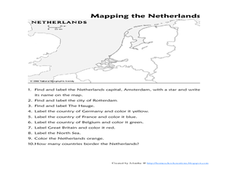
Mapping the Netherlands
In this Netherlands activity, students label cities, countries, landforms, and more. Students label 10 places in the Netherlands.
Curated OER
The Roman Empire-Map Activity
In this Roman Empire worksheet, students complete a map activity in which they label and color civilizations, countries and physical features as instructed. There are no maps included.
Curated OER
Labeling a Map of the British Isles and Elapsed Time
In this map work and elapsed time worksheet, students label England, Scotland, Wales, and Ireland on a map. They calculate the elapsed time of a delivery that is described in a word problem that is broken down into four parts.
Curated OER
Africa: Political Map
Students create a political map for Africa. For this country identification lesson, students locate Africa on a globe and discuss some of its major countries and bodies of water. Students complete a political map of Africa and test...
Curated OER
Map of Italy
In this map of Italy activity, students find, color and label cities, surrounding countries, bodies of water and landforms in the country of Italy.
Curated OER
Map of Egypt
In this map of Egypt worksheet, students label the cities, bodies of water, surrounding countries and color the map according to the directions.
Curated OER
Reading a Local and National Weather Map
Students investigate weather maps. In this weather lesson, students discover the meaning of different weather icons and symbols. Working independently, students use the local forecast to correctly label a state map.
Curriculum Corner
Earth Day Book
This Earth Day, celebrate our beautiful planet with an activity book that challenges scholars to show off their map skills, complete a crossword puzzle, write acrostic poems, alphabetize, and reflect on their personal Earth-friendly habits.
Curated OER
Labeling a Map of Australia
Third graders label a map of Australia. Using the internet, they research the history and maps of the continent and print a blank map. They review on how to use a compass rose and legend. In groups, they create a brochure to share...
Curated OER
Eastern Europe in 1989
Major political shifts occurred in Eastern Europe during the late 1980s. Locate, identify, and label 90 different areas on the provided map. A list of cities, countries, and water ways is provided.
Curated OER
Decolonization in Asia
Pin point areas in Asia that went through decolonization and regained independence from colonial rule. There are 32 countries and bodies of water to identify on the provided map.
Curated OER
Euro-Tourism
Learners design a tourist brochure using Publisher. They research an assigned European country. Students describe tourist attractions in their country and other interesting characteristics.


