National Geographic
Mapping the Shape of Everest
With Mount Everest as the motivator, your earth science class learns about topographic maps. Begin by showing a film clip from The Wildest Dream: Conquest of Everest, featuring fearsome virtual imagery of a path up world's tallest peak....
Just Health Action
Environmental Justice Matters: Mapping Environmental Justice Impacts (Part 1)
A case study of Seattle, Washington permits class members to compare and rank how different areas of Seattle are impacted by environment burdens. Groups investigate different zip codes, collect data on five categories, and color-code a...
Curated OER
Play Doh Map of Your State
Students create a state map using Playdoh. In this hands-on state geography lesson, students work in groups to form a three-dimensional map of their state using Playdoh made at home following a (given) recipe. Students use four colors...
Alabama Learning Exchange
Coordinate Geometry
Where do the coordinates lead? As children brainstorm ways to find the location of different buildings, they learn about coordinate points and how to use them to locate areas on a grid or map. They practice using ordered pairs by playing...
National WWII Museum
What It Takes to Win: Mapping Primary Source Evidence
World War II was not just waged in Europe and Asia; the home front was key to Allied victory. Using newspaper clippings from World War II and a map, scholars plot out wartime production in the United States. After that, class members...
National Endowment for the Humanities
On This Day With Lewis and Clark
Walk in the footsteps of Lewis and Clark as they discover the wonders, beauty, and dangers of the American frontier. After gaining background knowledge about Thomas Jefferson and the Louisiana Purchase, young explorers use primary...
Curated OER
What Do Maps Show?: Lesson 4 How to Read a Topographic Map
Students examine the use of topographic maps as two dimensional representations that show elevations and slopes with contour lines. They read maps of the Salt Lake City, Utah area and complete the associated worksheets that show map...
Curated OER
Exploring Arizona's Biotic Communities Lesson 1: Mapping Biotic Communities
As part of a unit on Arizona's biotic communities, young ecology learners create a map. They describe how humans and animals adapt in their habitat. They take notes and create graphic organizers from articles they read. Beautiful maps,...
EngageNY
Close Reading of Bullfrog at Magnolia Circle: Predators and Prey
Reading is fantastic, especially when it's reading about bullfrogs. Kids get cozy with predator/prey relationships as they hone their information-reading skills. They start out as they read a portion of the text aloud, then they...
Ontario
Reading Graphic Text
Do learners really need to be taught how to read cartoons, comic books, and comic strips? Yes. Just as they need to learn how to read other forms of graphic text such as diagrams, photos, timetables, maps, charts, and tables. Young...
McGraw Hill
Study Guide for Island of the Blue Dolphins
Dive your class into a reading of Island of the Blue Dolphins with this in-depth study guide. Breaking the novel into three parts, the resource begins each section with a focus activity that identifies a specific theme or question to be...
Curated OER
China Quest
Read and research information on China. Young researchers complete a knowledge hunt about China then locate and describe each location using directional words. They recognize the word meaning through context clues and application practice.
Curated OER
Where Am I: How to Read a Map
Third graders develop an understanding of maps. They explore what a map is, who uses maps, and how to use maps. Students investigate the compas rose. They create a compose rose which illustrates the cardinal directions. Students practice...
Curated OER
Mapping Perceptions
Students create and read maps. In this map skills lesson, students draw a map of their neighborhood, then use skills acquired during map-making to interpret a classmates map and a map of the Ming Dynasty.
Curated OER
Learning About Maps
Learners take a "field trip" with the teacher through the school then draw a diagram of what they saw. They bring the maps to the computer lab where they create electronic maps using the software program Neighborhood Map Machine.
Curated OER
Way to Go! Create a Road Map Game
Students create a travel game of one of the United States. They research a state of their choice and create a travel game using a common road map. They interpret map symbols as they calculate map mileage for their games. They create...
Curated OER
Where in the World Is Mexico?
Students practice map-reading skills as they locate Mexico and its cities on a world map. By creating a puzzle out of a map of Mexico, students engage in a meaningful hands-on activity to help them explore that country's geography.
Tennessee State Museum
An Emancipation Proclamation Map Lesson
Did the Emancipation Proclamation free all slaves during the Civil War? Why was it written, and what were its immediate and long-term effects? After reading primary source materials, constructing political maps representing information...
Illustrative Mathematics
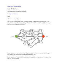
$20 Dot Map
Challenge the addition skills of young learners with this open-ended math problem. The task is simple, get from start to finish by connecting a series of three numbers. The trick is that the sum of the numbers must be less than or equal...
Institute for Geophysics
Understanding Maps of Earth
Here is your go-to student resource on primary geography concepts, including facts about the surface of the earth and its hemispheres, latitude and longitude, globes, types of maps, and identifying continents and oceans.
EngageNY
Establishing Structures for Reading: Getting the Gist (Chapter 1)
Class members review expectations for successful discussions before reading chapter one of A Long Walk to Water by Linda Sue Park. They engage in a think-pair-share to discuss the gist of the text and add their thoughts to their Readers'...
Curated OER
Map Exploration
Are you looking for a terrific lesson on map activities for your second graders? Then, this resource is for you! The activities range from decoding, to fill-in-the-blank, to read-and-search. There is a website activity related to maps...
Curated OER
Lewis and Clark
Students investigate Lewis and Clark. In this Lewis and Clark lesson, students search the Internet for information about Lewis and Clark and the Corps of Discovery. Students use maps to understand the explorations and decide which...
Curated OER
Caves
Explore caves with your class! Your scholars will participate in scientific observation, research, inference and deduction, reading, vocabulary, and writing activities about caves with this lesson plan. This resource contains five...
Other popular searches
- Map Reading Skills
- Earth Science Map Reading
- Esl Map Reading
- Map Reading Activities
- Reading a Map
- Basic Map Reading
- Map Reading Powerpoint
- Topographic Map Reading
- Map Reading Grade 6
- Lessons on Map Reading
- Elements of Map Reading
- Geography Map Reading Skills


