Curated OER
Topographic Mapping Skills
For this geography worksheet, students read an excerpt about topographic maps and why they are useful for various jobs. They also respond to eleven questions that follow related to the excerpt and locating specific map points on the map...
Curated OER
Representing Data 2: Using Box Plots
What information can be gleaned from a box and whiskers plot? Discuss the five summary values - minimum, maximum, upper and lower quartiles, and median - and what conclusions can be made from these values? Included here is a matching...
Curated OER
Writing/Setting/The Adventures of Tom Sawyer--Map Your Childhood Project
Students write using a strong sense of place. In this Adventures of Tom Sawyer lesson, students discuss the importance of setting to the novel. Students brainstorm five specific locations that contribute to their personal history....
Friends of Fort McHenry
British Attacks in the Chesapeake during the War of 1812
This is a fun mapping activity that will have your class knowing the ins and outs of the battles in the War of 1812. Your young cartographers will not only plot decisive attacks, but will analyze their purpose, goals, and impact on...
Curated OER
State Names: Frequency
Data grathers determine the frequency of specified data. They identify the frequency that specified letters occur in the names of all 50 states. They create stem-and-leaf plots, box-and-whisket plots and historgrams to illustrate the data.
Curated OER
Reading Study Guide: I Know Why the Caged Bird Sings
Meant for use with Maya Angelou's first autobiographical volume I Know Why the Caged Bird Sings, the materials here are designed for a homeschool setting, but they'd suit any classroom or text. Graphic organizers, chapter summary guides,...
Curated OER
Tortoise and Hare Races
Practice basic map skills with the story of The Tortoise and the Hare. After listening to the story, class members create a map that indicates the starting line, the path the animals took, where they stopped to rest, and the finish line....
Curated OER
Story Pyramids
Young writers generate descriptive words. They use pictures of various landscapes (from books, magazines, or the Internet) and complete a story pyramid. The pyramid (included here) asks to describe the main character, the setting, and...
Jordan-Granite Consortium
Scatter Diagram
You aced the first test, so your score on the second one shouldn't matter, right? Young pupils first draw a best fit line on a provided scatter plot showing test scores for two different tests. They then evaluate five statements on the...
Agriculture in the Classroom
A Holiday Tradition: Which Christmas Tree Will You Choose?
Different varieties of Christmas trees provide an interesting way to combine social studies, science, math, and technology. Class members not only research the history of the Christmas tree holiday tradition, they compare and contrast...
Curated OER
Non-Fiction Text Features
Distinguish between textual features of non-fiction in the book The Lewis and Clark Expedition and in the non-fiction story "Ta-Na-e-Ka." Third graders create posters and participate in group discussions to show their understanding of...
Mathematics Assessment Project
Bird’s Eggs
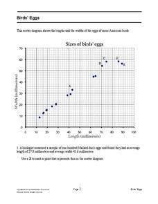
Are the length and width of birds' eggs related? Young ornathologists use a scatter plot to investigate the relationship between the length and width of eggs for Mallard ducks. They then determine the egg with the greatest...
Curated OER
Maps From Here to There
Students explore and analyze how to interpret a map by plotting a trip. They include landmarks, routes and directions along with the beginning and ending destinations. Each student pairs up to see if they can figure out where their...
Curated OER
Project Map: Scale Worksheet
In this map reading worksheet, learners determine the distance from a plotted treasure on a topographic map. They must adjust for magnetic declination.
Curated OER
Mapping Exercise
For this mapping worksheet, students are given data of children exposed to health risks and their geographical location. Students plot each child's home and the risk factors using an (x, y) grid. They answer 2 questions about the...
Curated OER
Learning Lesson: Analyzing a Weather Map
Students use weather maps to locate warm and cold fronts. They discover the different types of weather associated with these fronts. They also observe the weather in their local area.
Curated OER
Story map
In this story map learning exercise, students fill in a story map that contains the elements of conflict in a story. Students answer the questions of who, what, and why.
PHET
Where to See an Aurora
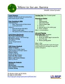
Where can you see an aurora in North America? After completing an astronomy activity, scholars can locate the exact coordinates. Pupils plot points of the inner and outer ring of the auroral oval and answer questions based on their...
Illustrative Mathematics
The Longest Walk
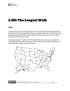
How long of a line can you draw within this activity? Learners pick two points outside and within the map to create the longest line they can. After drawing 10 lines, learners plot the length of each line on a line plot. Then they...
Curated OER
Understanding Protagonists and Antagonists
How can you tell if a character is a villain? What about a hero? Work on literary analysis with an engaging language arts activity. After completing an activity about the four types of conflict, learners fill out a character map about a...
NOAA
A Watery World
With about 70% of the earth's surface covered in oceans, it's fair to say that we live in a very wet world. Young scientists gain a better appreciation of this fact as they use maps to identify the world's ocean basins in the first...
EngageNY
Narrative Writing: Planning the Plot
You will never forget that moment. Scholars read a model narrative and analyze the moment a character became visible again. They compare the narrative to Okubo in Unbroken. Readers also assess the narrative essay according to a rubric...
Curated OER
Lesson 1: Plot Current Earthquake Data
Students access USGS earthquake information and plot the locations on a world map.
Curated OER
Constellation Mapping
Students plot constellations on a grid map. They discuss the various ways early explorers planned their travels. Students identify and recognize major constellations. They color their maps and take them home to try to find various...


