Curated OER
The Great Continental Drift Mystery
Students stud the concept of Pangaea by using Wegener's clues to construct a map of the continents joined together. They determine how fossil distribution can be used to enhance the study of continental drift. They locate the...
Curated OER
OPEC and the Energy Crisis
Students color the Middle East Nations of OPEC on outline maps. They discuss and watch a video about the United States reliance on oil producing nations of the Middle East. They participate in a discussion of the problems of the gas...
Curated OER
Media Center Map Skills
Student demonstrates the ability to locate, retrieve, and handle media and equipment by utilizing the library media center floor plan, symbols, and guides. They then use systems of classification to identify, locate, and retrieve materials.
Curated OER
Mapping A Stream
Students participate in mapping an actual waterway. They include reach lengths, transects, compass reading, and scale determinations. They include windfalls, plant cover, types of streambed composition, and landmarks such as trees and...
Curated OER
Mapping Your Neighborhood
Students define and outline their neighborhoods using GIS (geographic information systems) or a regional map and relate their neighborhoods to the principles of Smart Growth.
Benjamin Franklin Tercentenary
From Ben’s Pen to Our Lives
What would Ben do? Jumping off from the pseudonymous letters Ben Franklin fooled his older brother into publishing when he was still a teenager, young literary lovers dive into acting, writing, and addressing a local issue with wit and...
Curated OER
Street Cows
A light, and humorous lesson on "street cows" is here for you. Learners listen to the story, "Street Cows," which is embedded in the plan. On a map of the US and the World, they locate the cities where the "Cows on Parade" exhibit was...
Curated OER
Women in Texas Politics: Winning the Vote, Three Pioneers, and Serving the People
Fourth graders study women's involvement in Texas politics. In this US history instructional activity, 4th graders discuss woman suffrage, examine three Texas female pioneer legislators by reading biographies, and explore women's issues...
Curated OER
I Can Compass, Can You?
Students discover how to use geographic tools. In this compass lesson, students identify cardinal directions by appropriately using compasses along with a number of various maps.
Curated OER
What About Us? Women in the Civil War
Learners research the role of women in the Civil War. In this Civil War unit, students research the role women played during the war. This unit includes eight different activities including vocabulary, writing prompts and a literature...
Curated OER
We the People
Students create a map illustrating the three branches of goverment. They identify the branches of government and the shared or exclusive powers of each. Students use mapping as a prewriting stategy. They discuss our national...
Curated OER
Four Famous Faces
Each one of our quarters is embellished with a famous face or image representing the state it came from. This lesson uses South Dakota's state quarter to get kids thinking about monetary value, what the president of the United States...
Curated OER
The Brief American Pageant: Wilsonian Progressivism at Home and Abroad
Many various pieces of information about the Wilson administration adorn these slides. For instance, a map with 1912 election results, a chart detailing the organization of holding companies, and another map outlining U.S. presence in...
Curated OER
The Sweet Connection
Students use maps to find what crops are dominant in areas where honey bees are raised and discuss possible correlations. They mark the top ten honey- producing states on a US map.
Curated OER
ExplorA-Pond: 1st Grade Shapes
Young explorers review the basic shapes (circle, triangle, square, rectangle) and practice putting them together to make new shapes. Given an outline of a pond, they recreate it by combining other shapes.
Curated OER
Where Life Is Too Short
Pupils predict how a pandemic would affect aspects of South Africa's society. In this world issues and geography lesson, students read a letter outlining the problems affecting South Africa. Pupils discuss and analyze how resource...
Curated OER
Invasives and Marsh Birds
Students are taught that invasive plant removal can have a variety of impacts. They are shown this by using graphs. Students view maps of vegetation change on Iona Island. They discuss implications of changes on marsh birds using data...
Curated OER
Indian Women in Texas History
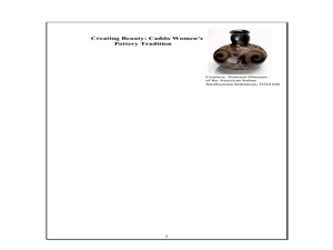
Fourth graders study Indian women in Texas. In this US history lesson, 4th graders discuss what each Indian woman's contribution was by completing a timeline and table. Students examine the Caddo Women's pottery tradition and write an...
Curated OER
Riding With Alice
Student listen to Don Brown's, Alice's Grand Adventure before discussing cross country travel. They trace Alice's travels on an outline map of the US and focus on the state of Indiana. They color and label the counties that Alice...
Curated OER
ADULT ESOL LESSON PLAN--Environment and the World
Students locate and trace Florida on a United States map as well as their local counties and city of residence on a state map. In addition, they label all the directions north, south, east and west on each map.
Curated OER
Early Explorers
Fifth graders study early explorers. In this World history lesson, 5th graders draw an outline of a map labeling each part, build geographical features out of dough, and paint each of the land and water features.
Curated OER
Hyper Book Reports
Fifth graders create a multimedia book report using a tree map to classify the elements fo fiction books.
Curated OER
Flags as Tools to Share Identity
Students compare flags, locate states on map with flag picture or miniature. Read a newspaper article outlining five vexillology standards for rating flags. They develop a personal flag with an essay interpreting their flag to the reader.
Curated OER
Multinational Corporation Relocation
Students examine and analyze the concept of why multinational corporations relocate production facilities from developed nations to less developed nations. They explore the patterns and networks of economic interdependence incorporating...


