Curated OER
Asia and the South Pacific : Political Map
In this Asia and the South Pacific map worksheet, learners examine the boundaries of the nations in this region of the world. Students also note the location of capital cities as they are denoted by stars. Major bodies of water are labeled.
Curated OER
Central America Outline Map - Labelled
In this Central American political map worksheet, students make note of national boundaries and capitals in this region of the world. National capital city locations are noted with stars.
Curated OER
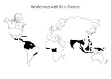
World Map With Rain Forests
In this geography worksheet, students study a map of the world which shows shaded areas indicating where the rain forests are located. There are no labels for countries or continents.
Curated OER
Mapping the War
Students work in pairs to draw their own maps as specified of World War II areas. When all projects have been completed let one group at a time share their assignments with the rest of the class. Compile all the maps into a classroom...
Curated OER
World Map Labels
In this geography skills worksheet, students identify the countries and bodies of water labelled on the maps of the world, Africa, Asia, Canada, Europe, the Caribbean, the Middle East, North America, Australia, and South America.
Curated OER
Introduction to the World Globe
Students examine a globe and the world map to see what constitutes the differences. For this world map introductory lesson, students discuss what they see when they view the globe. Students then, look at a world map and compare the...
Curated OER
European Union Map Quest
Sixth graders identify countries of the European Union. They locate countries of Europe on a map and pair with a student to complete a blank map of Europe. They label each country and complete worksheets for the European Union. They...
Curated OER
Me on the Map: Homes, Neighborhoods, and Communities
Students read a book about maps and identify the differences between a picture and a map. In this maps lesson plan, students also label maps of their home, neighborhood, and community.
Curated OER
Through the Forest and Home Again: Maps Help Us Find Our Ways
Students read Little Red Riding Hood, focusing on her path home to Grandma's house. In this language arts and geography lesson, students perform a reader's theater, re-creating the walk home and possible routes that could have been...
Curated OER
Leapin' Landmarks: Locating 10 Man-made Landmarks Around the World
Third graders label continents, oceans, and major mountain ranges on maps and use the maps to write an informational report about landmarks. In this landmarks lesson plan, 3rd graders write about 1 major landmark.
Curated OER
Map Skills
Young scholars examine the nations, battlefields, troop movement of the Germans through Belgium and the location of both fronts during World War I by creating a map. They visualize the strength of the Germans early in the war.
Curated OER
WORLD GEOGRAPHY
Students identify and analyze map symbols and map grids by completing various worksheets and creating their own map using these skills. Students identify and analyze what latitude and longitude are on a map to play a game of Bingo....
Curated OER
Voyage to the New World
Middle schoolers examine the exploration of the New World. They write a descriptive account of the first encounter between Europeans and Native Americans, analyze and label maps, plot Columbus's journey on a map, and write a chapter...
Curated OER
Maps, Maps, and More Maps
First graders create a map and display an understanding of the cardinal directions. In this map skills lesson, 1st graders listen to stories where a map would come in handy, create their own map, and use the cardinal directions accurately.
Curated OER
Rivers, Maps, and Math
Students use maps to locate and label the major rivers of North and South America. Using the internet, they identify forests, grasslands, mountain ranges and other landforms on the continents as well. They compare and contrast the...
Curated OER
Where in the World Is ...?
Students move themselves around a "world" map on the classroom floor, using lines of latitude and longitude to locate specific spots. They determine the locations of 11 countries where Peace Corps Volunteers are serving and identify in...
Curated OER
Ticky Goes to Jr. Map School
Second graders explore the compass rose and North - East - South - West.
Curated OER
The Expansion of Islam to 750
Track the expansion of Islam throughout the Mediterranean and Near East. Locate and label 17 different areas that adopted the tenets of Islam.
Curated OER
The Barbarian Invasions of the Roman Empire
Fifteen different locations to map and correctly label. Use the provided list to show major areas of Barbarian invasions occurring during the Roman Empire.
Curated OER
The Spread of Printing
Document the spread of printing, which occurred in the 1500s. Use the provided list of water ways, countries, and cities to label specified locations on the map.
Curated OER
Decolonization in Asia
Pin point areas in Asia that went through decolonization and regained independence from colonial rule. There are 32 countries and bodies of water to identify on the provided map.
Curated OER
European Language Groups, 1850
Document the linguistic diversity and major language groups common to Europe in 1850. A map and a list of regions, countries, and water ways is provided.
Curated OER
Geography: Puerto Rico
Take a trip to Puerto Rico! Learners engage in a web quest, identify Puerto Rico on the map, and gather information related to physical features and cultural factors. Their efforts culminate when they design a brochure comparing the...
Curated OER
Plotting a Hurricane Using Latitude and Longitude
Learners define and use "absolute location," latitude, and longitude. They locate on a map or globe the Earth's poles, circles, tropics, and beginning points of measurements for latitude and longitude.


