Curated OER
Southeast Asia and the South Pacific: Political
In this Southeast Asia and the South Pacific political map worksheet, students examine boundaries of each of the countries and the placement of the capital cities. The major bodies of water are labeled.
Curated OER
South Asia: Political Map
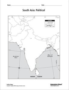
In this South Asia outline map worksheet, students & examine boundaries of each of the countries in the region. This map is labeled with the country and capital city names.
Curated OER
World: Political Map
In this world political outline map worksheet, students examine boundaries of each of the countries in the world. This map not is labeled.
Curated OER
Asia and the South Pacific: Political Map
In this Asia and the South Pacific map worksheet, students examine national political boundaries and national capitals in this region of the world.
Curated OER
U.S. Political Map
For this political map worksheet, students use the map of the United States and the 7 cities to measure the straight-line distance between the cities. Students add the total number of miles traveled and write their answers in the spaces.
Curated OER
United States Regions
In this United States political map worksheet, students examine regional census boundaries of the US. State boundaries are also included.
Curated OER
United States Map
For this United States political map worksheet, students examine national and state boundaries. The map also highlights the location of each of the state capitals and the national capital.
Curated OER
USA Capitals Map
In this United States political map instructional activity, students examine state boundaries and locations of each of the state capitals.
Curated OER
South America Map
In this South American political map learning exercise, students examine both national boundaries and national capitals.
Curated OER
Europe: Political Map
In this Europe political map worksheet, students examine each country's boundaries. The map also highlights each of the nation's capitals with a star.
Curated OER
US: Midwest Region
In this United States political map worksheet, students examine the state boundaries of the Midwestern Region. The map also highlights each of the state capitals denoted by stars.
Curated OER
South Asia: Political Map
In this South Asia political map worksheet, students examine the national boundaries. The map also highlights each country's capital city.
Curated OER
South America Map
In this South America political map worksheet, students examine the country boundaries. The map also labels each of the countries and their capitals.
Curated OER
Central America: Unlabeled Map
In this Central American political map worksheet, students examine the boundaries of the countries and capital cities located in this region of the world.
Curated OER
Mexico: Political Map
In this Mexico political map worksheet, students examine state boundaries. The map also highlights major cities in Mexico.
Curated OER
Central America Map
In this Central American political map learning exercise, learners make note of national boundaries and capitals in this region of the world.
Curated OER
Mexico: Political Map
In this Mexico political map activity, students examine state boundaries. The map also highlights major cities in Mexico. This map is unlabeled.
Curated OER
Europe Labeled Map
In this Europe political map worksheet, students examine the national boundaries. The map also highlights each of the nation's capitals with a star. The countries and capital cities in this map are labeled.
Curated OER
World Political Map
In this blank outline map worksheet, students note the political boundaries of the nations of the world on a Mercator projection map.
Curated OER
States: United States Map
For this United States political map worksheet, students examine state boundaries. The map is labeled with the names of each of the 50 states.
Curated OER
Using a Political Map
In this online interactive map activity worksheet, learners examine a political map of New Jersey and respond to 9 fill in the blank questions.
Curated OER
Map It!
Fourth graders collect and explore different maps and their uses before using the program Pixie to create maps of geographic features, political features, and economic information for the state in which they live.
Curated OER
Food Detectives
Students investigate the regions in which particular grains are grown. Using the packaging from a variety of foods, grains are identified and the general locations where they are grown are plotted on a map.


