Curated OER
Cotton Journey
Students use "Cotton Journey-A Field Trip In A Box" kit to relate the significance of cotton to the Civil War period and to study the cotton industry in general.
Curated OER
"Eggs-treme" Egg Hunt
Students practice reading a map of the classroom or playground. They hide plastic eggs and draw a map identifying the location of two eggs hidden in the classroom or on the playground.
Curated OER
Let's Play Geography Twister
Students practice geography skills by playing a game based on Twister. Students manipulate their position on a map by placing their arms and legs on the appropriate state or country called out by the teacher.
Curated OER
The Earth's Surface
Students identify the characteristics of places. In this communities lesson, students discuss what they observe when they travel and construct a list of places in their neighborhood. Students use a Landscape Picture Map to circle...
Curated OER
Prairie Voices: Community Development, Investigating Local History
Students investigate local history. In this research skills lesson, students examine historic landmarks, tax records, fire maps, town plans, historic photographs, newspapers, and other primary sources to learn about local communities in...
Curated OER
Our Country's Geography
Third graders study geography. In this United States landforms lesson, 3rd graders create a map of the U.S. made out of dough. They use various edible treats to mark the country's capital, the plains, the mountains and the rivers &...
Curated OER
This Land is Your Land - Delaware
Learners determine how land was divided and marked for boundaries in the early days of settlement in Delaware. Students mark out land on the playground according to the methods used by the early settlers. Learners write a description of...
Curated OER
"Place the State" Game
Students participate in a computer game in which they locate and place the U.S. states on a blank outline map. In small groups, they take turns dragging and dropping the states in the proper location on a map.
Curated OER
Four Main Directions
Students describe directions using a globe for north, east, south and west. In this mapping lesson students identify the north and south pole. Students understand the importance of the equator and the Prime Meridian. Students explain how...
Curated OER
Where in the world is...
Students identify locations around the world. In this mapping lesson, students place tag board pieces with names of locations on a wall map of the world. Initially, students identify states, then cities, then continents,...
Curated OER
Are There Really Fifty-Three Nations Within Africa?
Students color a map showing that Africa consists of 53 nations and recognize the difference between a nation and a continent. The main objective of this activity is for students to realize that Africa is a continent with many nations...
Curated OER
Seas, Gulfs and Bays
Students define gulf, bay, and sea. In this bodies of water mapping instructional activity, students locate seas, gulfs and bays and explain how they knew which body of water it was.
Curated OER
Identifying Border States of the U.S.
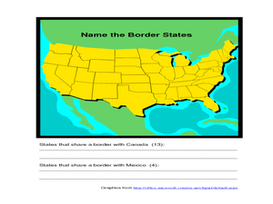
For this identifying border states of the U.S. worksheet, 3rd graders visually identify then write the names of the states that border Canada and Mexico; page 1 is a lesson, page 2 is the worksheet.
Curated OER
Introduction to the World Globe
Young scholars examine a globe and the world map to see what constitutes the differences. In this world map introductory lesson, students discuss what they see when they view the globe. Young scholars then, look at a world map and...
Curated OER
Using the Four Main Directions in the Classroom
Students utilize a compass to determine where North is in the classroom. In this direction lesson, students label the four main directions. Students locate features in the classroom and describe the directions to get to them. Students...
Curated OER
The Fifty States
Students research to find information about the U.S. States. In this fifty states instructional activity, students choose a state to research and locate it on the map. Students research to find the population of that state and record by...
Curated OER
Guide Me "Home"
Students find how freedom quilts helped free slaves. In this American History lesson, students read the story Sweet Clara and The Freedom Quilt and discuss the Underground Railroad. They use their map skills to locate...
Curated OER
Africa - Not Just One Big Safari
Students draw a picture of an African city that is similar to a U.S. city and discover how other parts of the world have the same types of buildings. In this global similarities lesson, students create a map of an ...
Curated OER
How Will We Get There?
Students discuss and make a T chart of how to travel in Hawaii and understand that it is a group of islands that you cannot drive to. In this Hawaii lesson plan, students also discuss the kinds of transportation we use on the main land.
Curated OER
Scrapbook of Freedom
Third graders create a scrapbook using personal narratives and samples of artifacts to connect to maps of geographical locations of the Underground Rail Road. they describe at least one of the feelings a child slave might have had...
Curated OER
Toy Making and Resourcefulness
Students demonstrate their understanding of resourcefulness by making a toy and describing how they were resourceful. They find Malawi on a map and tell the interesting things about the book Galimoto.
Curated OER
Continents and Critters
Students investigate and identify the continents of the world. They identify and locate the seven continents on a map, and label a coloring page of a world map. Students then conduct research on an assigned continent, and write and...
Curated OER
Music in Nature
Students research the Incan civilization. In this Incan civilization lesson, students study the geography of the Andes mountains and play an Andean siku. Students discuss how the sounds of nature influenced their musical piece.
Curated OER
Helping Countries in Turmoil
Students discover the struggles of emerging democracies. In this service learning lesson, students research a non-profit agency that is assisting the people of an emerging democracy and create and advertisement.


