Curated OER
Technology Integration
Third graders describe and locate the five geographical regions of the state of Virginia. Using that information, they organize the descriptions in a database they created. They are graded based on accuracy and spelling all noted on a...
Curated OER
What's In a Name?
Students examine the origins of the names of U.S. states, focusing on names that were derived from Native American words. They are provided with lists of the names of the 50 states, and then research online or in library resources the...
Curated OER
Tango Stories
Students listen to tango music and research the country it came from. In this music instructional activity, students find that tango music comes from Argentina. They listen and dance to the music and then write stories.
Curated OER
The Flow of Women's Work: How Cultures are Alike and Different?
Learners examine gender roles in various cultures. In this flow of women's work lesson, students compare water related work in rural Africa to that in their own households.
Curated OER
Teaching the Five Themes of Geography Through Picture Books
Read the story Make Way for Ducklings and introduce little ones to the five themes of geography. Reread the story, while displaying transparencies to reinforce the five themes. In groups, learners view pictures and identify the themes on...
Curated OER
You Can Find It!
Pupils locate different places including U.S. cities using longitude and latitude coordinates. In this longitude and latitude lesson plan, students locate 10 different locations.
Curated OER
States And Shapes
Students work together and investigate the shapes of 50 states. They identify the states that they find hardest to recognize. The group then list the states in order from most difficult to just difficult to recognize and create a...
Curated OER
The Physical World: Continents and Oceans
In this world map worksheet, study the map of the continents and oceans. Learners label each of the 12 sections of the world map.
Curated OER
Geography: Why Is the Sacremento Valley a Good Place to Grow Rice?
Third graders locate the Sacramento Valley in California where rice is grown. In this rice growing location lesson, 3rd graders locate the Sacremento Valley, California on a map, and color the mountain ranges and terrain that is around...
Curated OER
Southwest Bus Ride
In this geography skills practice worksheet, students take a trip through the southwestern United States as they examine maps, information cards, and respond to 12 questions.
Curated OER
Medieval Times: Castles, Knights, and Heraldry
Students demonstrate the ability to use the computers for research and exploration of castles and any other sources needed and locate web sites for various needs. They explain what a coat of arms was and make their own .
Curated OER
Finding Your Way On the Farm
Third graders explore the food industry by viewing a presentation about farming. In this farming geography lesson, 3rd graders view globes and maps while identifying the prime geographical locations for fertile land. Students view a...
Curated OER
Loco for Cocoa
Third graders research the history of cocoa. In this cocoa lesson plan, 3rd graders investigate how the cocoa bean has been traded from one country to another. Students create a timeline and map to track the history of the cocoa bean.
Curated OER
Families Around the World
Students discover the similarities and differences in families from around the world. In this multicultural lesson, students create their own family album and label each family member. There are suggested activities such as investigating...
Curated OER
Identifying Continents and Oceans
Students locate and identify the four major oceans and the seven continents on a world map. They use an unlabeled world map and compass rose to describe relative locations of the continents and oceans.
Curated OER
Then and Now
Students list the similarities and differences seen as they compare and contrast historical and current street maps of their local communities.
Curated OER
Geographics in Arkansas
Third graders discuss where Arkansas is located on the United States map. They use geographic tools to participate in activities.
Curated OER
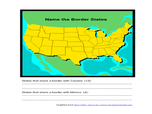
Identifying Border States of the U.S.
For this identifying border states of the U.S. worksheet, 3rd graders visually identify then write the names of the states that border Canada and Mexico; page 1 is a lesson, page 2 is the worksheet.
Curated OER
"Where in the World is my School?"
Students learn new vocabulary and discuss what GPS is and does. They locate their school using the equipment.
Curated OER
Discovering Dinosaurs: Planning your Summer Vacation
Students use the online Atlas of Canada to gather information about places in Canada.
Curated OER
Walking the Five Themes - Your Community to Ours
Students in two classrooms share information about their communities in classrooms throughout the year. In groups, they identify the physical and human characteristics of each area and how they change through time. They also discover the...
Curated OER
Geography: World Dynamics
Students discuss and examine how the world is changing. After reading an article, they discover the immediate changes that have taken place and how they have effected living things. They complete a worksheet identifying the changes as...
Curated OER
Japan: A Cultural Study
Third graders "take a trip" to Japan. They discover what life is like for a typical Japanese child and compare/contrast it to life in America. They give an oral presentation of Japanese holidays and festivals.
Curated OER
The Branding of America (And Your State)
Students investigate about the origins of some major U.S. brands. They explore local products that stimulate the economy. Students create a map showing where those products originate. Students discover the products that their local area...


