Curated OER
Great Cities of the Middle East
Students explore the cities of Cairo, Istanbul, Jerusalem, Mecca and Tehran. In this Middle East lesson plan, students complete a map, research one of the five the cities and prepare a presentation that includes details about the city. ...
Curated OER
Lesson 3: Seven Day Road Trip
Students plan a seven day road trip. In this travel lesson, students plan a driving trip that includes five major cities or attractions in Florida or another state of their choice. They show the trip on a map, calculate distances that...
Curated OER
The Beautiful People of Africa
Students discover the people of Africa by creating a PowerPoint presentation. In this African culture instructional activity, students utilize the Internet to investigate a specific African tribe and their specific location, culture,...
Curated OER
Famous Landmarks
Students research a country and the national holidays the people of that country celebrates. In this cultural celebrations lesson plan, students are assigned a country, research the major holidays of that country, and create a 12-month...
Curated OER
Biomes Summary-Temperature, Precipitation, and Location
Students examine the weather conditions of the various biomes on a world map. In this geographical weather lesson plan, students identify the seven biomes and color each biome a specific color. Students view a list of the average...
Curated OER
Put Your Face on the Map
Learners investigate topography and contour lines by examining a human face. In this mapping lesson, students create a plaster cast of a face and create a map of the contours of the face one centimeter at a time. Learners examine the...
Curated OER
Let Me Tell You About My State
Fifth graders research one of the 50 U.S. States that they were unfamiliar with. In this U.S. Geography instructional activity, 5th graders utilize encyclopedias as well as the Internet to research a chosen U.S. State in order to write...
Curated OER
Traditional Remedies
Learners discover alternative medicines from around the globe. In this world culture lesson plan, students read text from Africa, Ireland, Tibet and Tanzania discussing known remedies to diseases. Learners discuss with each other their...
Curated OER
Creating a Map
Students create a map of their community. In this mapping lesson, students identify various geographical features and the cardinal directions on maps displayed in the classroom. Students are divided into three groups to create a large...
Curated OER
Geography and Climate
Students investigate geographical locations and their own personal experiences with the environment. For this environmental identification lesson, students participate in a match game using certain environmental and geographical terms...
Curated OER
Smithsonian Asian Pacific American Lesson: Immigration
Many of your class members will have heard of Executive Order 9066 and the Japanese internment camps of World War II. Some may even recognize the terms “Issei” and “Nisei,” but few will have heard of Enemy Alien Hearing Boards, of the...
Curated OER
The West the Railroads made
Students investigate the effects of time and distance for the creation of a successful railroad. In this railroad lesson, students recognize the railroad's need for an exact time schedule was the cause for the creation of time zones. ...
Curated OER
All About Measuring with the Metric System
Students discover the metric system through video clips and Internet activities. In this measurements lesson, students practice using the units of measure for the metric system and compare them to the less popular English system....
Curated OER
State Factsheet for . . .
In this graphic organizer about a State activity, students research and record specific information about one state. Students write 10 answers.
Curated OER
The Country of Venezuela
In this map skills of Venezuela worksheet, students use an outline map to find an label important cities landforms, and bodies of water. Students label and color code 10 answers.
Curated OER
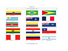
South American Flags
In this identifying flags from the countries in South America instructional activity, students write the names of the countries under their flags. Students answer 15 questions.
Curated OER
The Country of Kenya
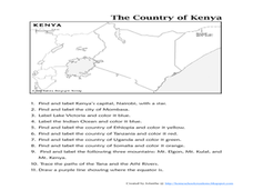
In this map completion activity, students observe a map and map scale of Kenya to find and label bodies of water, cities, countries, and the equator. Students answer 11 questions.
Curated OER
African Flags
In this recognizing the flags from African countries activity, students match the African country's name with its flag. Students answer 20 questions.
Curated OER
The World is a Village
Students observe Americans through the eyes of the world. In this human population activity, students utilize the Internet to view the World Pop Clock and follow the world's population by the minute. Students predict what the world's...
Curated OER
Mapping Spain
For this map labeling worksheet, students follow directions to label 10 items on a map of Spain. They label the capital city of Madrid, the Pyrenees Mountains, surrounding water bodies and countries. They trace the flow of the Duero River.
Curated OER
Situation of America, 1848
Students explore 19th century American artwork. In this cross curriculum New York history and art appreciation instructional activity, students view a reproduction of the painting "Situation of America, 1848," and identify visual...
Curated OER
A Treaty Tail: U.S. - Indian Treaty Councils in the Northwest
Learners view a painting as a document to find out about the Indian Treaty Councils. In this artist's perspective lesson, students study the conflicts as shown in various pictures. Learners answer questions about what they learn from...
Curated OER
Agricultural Hard Times And The Great Depression 1920 - 1930, Screen 5 and 6
Students study the interaction between the inhabitants of the state of Utah and its geographic features. In this Utah geography lesson, students determine how the geographic feature of Utah affected it settlement, land use and...
Curated OER
Diversity
Students work in groups to research and prepare an oral report about a region. In this regions lesson, students find out about the geography, population, state capitals, and landmarks. Students assign attributes to the people based on...


