Curated OER
Introduction to the World Globe
Young scholars examine a globe and the world map to see what constitutes the differences. In this world map introductory lesson, students discuss what they see when they view the globe. Young scholars then, look at a world map and...
Curated OER
Village Children in Northern Pakistan
Student use maps to answer geographic questions. They analyze Earth's surface by using a map to identify physical features that lead to different transportation routes. Student create a collage to show geographic insight into the topic...
Curated OER
Czech Republic Outline Map
For this blank Czech Republic outline map worksheet, students study the physical boundaries of the country. This outline map may be used for a variety of geographic activities.
Curated OER
Social Studies and Children's Literature
Students write a journal in response to literature. The story that is read is about prairies. The subject of prairies becomes an object for research. The culminating activity is the making of a map where prairies exist in the United States.
Curated OER
New Hampshire Map
In this state maps worksheet, students identify the state map of New Hampshire. Students fill in the state capital, major cities, and other attractions.
Curated OER
Go Maryland! Our State's Geography & Economy
Fifth graders design and create a brochure that may be used by the Maryland Department of Business and Economic Development to attract visitors in the 3 different regions of the state. In this Maryland state lesson, 5th graders research...
Curated OER
States/Capitals L-N: Matching
In this geography practice worksheet, students match the 17 listed states to the appropriate 17 listed capital cities located in the United States.
Curated OER
Thematic Unit: Beginning Holocaust Studies
Fifth graders discuss concepts of diversity, culture, and prejudice, gain understanding of harm caused by prejudice, and demonstrate ability to think critically and a desire to act morally.
Curated OER
Let's Play Geography Twister
Pupils practice geography skills by playing a game based on Twister. Students manipulate their position on a map by placing their arms and legs on the appropriate state or country called out by the teacher.
Curated OER
Matching the Globe with the Map
Students examine how to use a globe. In this globe and map comparison lesson, students discuss how the globe and map are alike when looking at Africa and Antarctica. Students investigate shapes and sizes of globes versus maps.
Curated OER
Maps In Our Everyday Lives
Young scholars break into groups and complete a chart about information on maps of their hometown.
Curated OER
The Geography of Tornadoes OR
Students learn some basic facts about tornadoes and map two selected tornado statistics by state, and observe, analyze and speculate about the pattern(s) created by the completed map.
Curated OER
U.S. Archaeological Sites: Geography Practice
In this archaeological sites worksheet, students read about sites in the Unites States and use a map to complete a set of 7 short answer questions.
Curated OER
U.S. geography for Children: New York
In this geography activity, 5th graders study the state of New York. Students follow the given directions to complete 5 tasks on the state map that is given.
Curated OER
Texas: U. S. Geography for Children
In this Texas map instructional activity, students locate and label key features of Texas on the map and create icons to symbolize the economy and culture of Texas.
Curated OER
Mapping Africa
Young scholars identify the location of parallel and meridian coordinates. They illustrate their understanding of the physical shape of the continent of Africa through a mapping activity, then explain the processes that have influenced...
Curated OER
North America
In this map of North America worksheet, students study the map of North America and then write the names of the 11 countries on the provided lines.
Curated OER
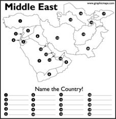
Middle East
In this map of the Middle East worksheet, students study the map of the Middle East and then write the names of the 20 countries on the provided lines.
Curated OER
Canada Geography PowerPoint
Young scholars create a PowerPoint about Canadian geography or history. In this Canada lesson, students spend two days researching their Canadian topic in the library and online. They create a PowerPoint presentation and add pictures...
Curated OER
The Middle East- Geography
Students discover the geography of the Middle East. In this geography lesson plan, students use reference books and the Internet to research the geography of the Middle East. Students complete an activity sheet to match the capital...
Curated OER
Geography Journey
In this geography worksheet, students use a map of Amtrak train routes (not included) to answer 10 short answer questions. Students describe physical features and landmark cities they would see if traveling by train across the country.
Curated OER
Illinois State Map
In this Illinois geography learning exercise, students color and label a map of Illinois. Students study the location of the capital and where Illinois is situated in the United States. There is a black line map of the state with a grey...
Curated OER
Pennsylvania State Map
In this geography of Pennsylvania worksheet, learners color and label a map of the state. Students also study the location of Pennsylvania on a grey background map of the entire 50 states.
Curated OER
Utah State Map
For this geography of Utah worksheet, students color and label a map of the state of Utah. Students also study a second map that shows the location of this state in the U.S.


