Curated OER
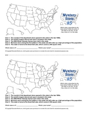
Mystery State # 5
Mystery state number five is none other than Utah! Quiz your kids on state knowledge while building deductive reasoning skills. They use each of the five clues to determine the name of the mystery state. A great warm up when studying...
Curated OER
Arkansas: A Changing Climate, a Changing Land
Here is a instructional activity on the climate zones and geography of Arkansas. In it, learners look at maps (embedded) of different climate zones found throughout Arkansas. They engage in discussions regarding how global warming and...
US Mint
Symbols in My Eyes
Explore the hidden meanings behind the images on US currency with this elementary school lesson on symbolism. Starting with a class discussion about symbols, children go on to brainstorm different objects that represent the Unites...
Curated OER
Create Your Own Country Project
Young scholars demonstrate their knowledge of geography with this fun, collaborative social studies project. Working in small groups, students develop their very own countries, writing descriptions...
John F. Kennedy Presidential Library & Museum
Red States/Blue States: Mapping the Presidential Election
Young historians investigate how voting patterns have changed by comparing the outcome of the 1960 election to the outcome of the recent election. A creative final assessment has participants making a news show wherein they provide...
Howard Hughes Medical Institute
BiomeViewer
Which holds more influence, the environment over humans or humans over the environment? Young scientists explore an online interactive that addresses this discussion. They observe changes in the natural world over time and see which...
Curated OER
Africa: Geography Concept Map
In this geography skills worksheet, students complete a graphic organizer where they list African countries and their geographic features, languages spoken, natural resources, and historical facts.
Curated OER
Call to Arms: A Service Project
Sick of selling candy and washing cars? How about hosting a Digital Day or a Learning Lunch? The suggestions here make fund raising fun and rewarding. Raise money to preserve important maps and other primary source documents.
Curated OER
The Ie Storm 1998: Maps and facts activity
Students investigate the St. Lawrence River Valley, ice Storm of 1998. In this middle school mathematics lesson, students interpret ice storm data from tables and maps. Students write about their own experiences of the ice...
Curated OER
Latin American Relief Map
Students, in groups, research, design and construct a relief map of a section of Latin America using papier-mache. They show major landforms, elevations and notable bodies of water. They present their maps to the class.
National Geographic
Types of Volcanic Eruptions
Blow the roof off your classroom with this multimedia science instructional activity on volcanic eruptions. A short online video teaches young geologists about shield and composite volcanoes and explores the examples of Kilauea and...
Curated OER
The Time Has Come: Poetry and Drama Use in the Geography Class
Middle schoolers use drama and poetry in their Geography class. In groups, they role play an interviewer or the interviewee in various plays that were presented to them. In their role, they must locate and label where the countries...
Curated OER
Learning About Location: Charting the Path of the George W. Elder
Young scholars acquire a working knowledge of the geographical concepts: absolute location, relative location, longitude and latitude. They analyze primary sources that shows the physical and human characteristics of the places along...
Curated OER
Maps that Teach
Learners study maps to locate the states and capital on the US map. Students locate continents, major world physical features and historical monuments. Learners locate the provinces and territories of Canada.
Theodore Roosevelt Association
Roosevelt's Legacy: Conservation
The legacy of Theodore Roosevelt carries through modern American politics, economics, foreign policy, and society. But his proudest and most profound efforts were in the world of conservation, and in preserving the natural beauty of...
Happy Housewife
State Notebooking Pages
When learning about US geography, it can hard to remember facts about 50 different states. Help your young scholars organize all of this information with a collection of easy-to-use note-taking guides.
Bowland
Alien Invasion
Win the war of the worlds! Scholars solve a variety of problems related to an alien invasion. They determine where spaceships have landed on a coordinate map, devise a plan to avoid the aliens, observe the aliens, and break a code to...
Curated OER
Beyond Demographics
Students study the culture of the Dominican Republic. In this Peace Corps lesson, students watch, "Destination: Dominican Republic." Students also examine primary source materials on the nation and discuss their findings.
Curated OER
United States Map Quiz
In this online interactive geography quiz worksheet, students respond to 50 identification questions about the shapes of countries shown. Students have 5 minutes to complete the quiz.
Kids Discover
Ancient Egypt by KIDS DISCOVER
Discover Ancient Egypt! Learn about mummification and gods, visit pyramids and temples, examine cliff carvings and paintings, take quizzes and engage in activities. Colorful, interactive, and easy to use, this app is not just for kids!
Curated OER
Using Literature to Introduce the Five Themes of Geography
Students listen to a read aloud of "If You Grew Up With Abraham Lincoln". Using the text, they identify examples of the five themes of geography and write them down. Using a map, they plot the places mentioned in the book and sort facts...
Curated OER
Exploring the USA and the World with Cartograms
Students investigate cartograms in order to explore the different countries on Earth. In this world geography lesson, students use the Internet to analyze data on different cartograms. Students compare data, such as population density,...
Curated OER
Oceania Map Quiz
In this online interactive geography quiz learning exercise, learners respond to 14 identification questions about Oceania. Students have 2 minutes to complete the quiz.
Curated OER
Australia Cities Map Quiz
In this online interactive geography quiz activity, students respond to 17 identification questions regarding Australian cities. Students have 3 minutes to finish the timed quiz.


