Curated OER
North America
In this map of North America worksheet, students study the map of North America and then write the names of the 11 countries on the provided lines.
Curated OER
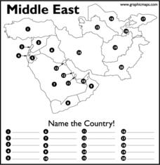
Middle East
In this map of the Middle East worksheet, students study the map of the Middle East and then write the names of the 20 countries on the provided lines.
Curated OER
Canada Geography PowerPoint
Young scholars create a PowerPoint about Canadian geography or history. In this Canada lesson, students spend two days researching their Canadian topic in the library and online. They create a PowerPoint presentation and add pictures...
Curated OER
Geography of Japan
Pupils complete a worksheet that guides them through an overview of Japanese geography. Students research the topography, climate, population and size of Japan and consider how these factors work together to produce Japanese culture.
Curated OER
Geography Journey
In this geography worksheet, students use a map of Amtrak train routes (not included) to answer 10 short answer questions. Students describe physical features and landmark cities they would see if traveling by train across the country.
Curated OER
Africa: Geography Concept Map
In this geography skills worksheet, students complete a graphic organizer where they list African countries and their geographic features, languages spoken, natural resources, and historical facts.
Curated OER
The Geography of Renaissance
Students use the internet to research the geography of the Renaissance. Using maps of Europe, they identify at least three key cities during the time period and discuss the main types of transportation. They research the various customs...
Curated OER
Tasty Mapping
Students create an edible map. In this civics and geography lesson, students research their town's features and local government. Students work in groups to design and create a physical map of their town based on research.
Curated OER
Lesson Plan: Five Themes of Geography
After learning the five themes of geography, learners take an Internet trip and categorize information found into one of the five themes. They answer five questions about the places explored. That is about all there is to this lesson; it...
Curated OER
Three Mapping Activities
Pupils label three maps of China after being introduced to background information about the country. In this geography lesson plan, students color two maps and label various points of interest in China. Finally, pupils draw...
Curated OER
Victims of Geography
Students examine the toll taken on New Orleans by Hurricane Katrina. In this current events lesson, students visit selected websites to discover details about the geography of the city and the hurricane itself.
Curated OER
Globe Game
Students are arranged into groups and are given a map or globe. Students select a location on the map. Students as yes and no questions to guess the specific place that was chosen.
Curated OER
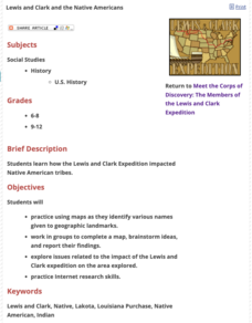
Lewis and Clark and the Native Americans
Students practice using maps and identifying landmarks on the Lewis and Clark expedition. They research Lewis and Clark's relationship with the Native Americans and report their findings to the class. They identify the impact of the...
Curated OER
Quilt? What Quilt? I Don't See a Quilt!
Students analyze maps and cultures of major cities in the state of Arizona and designate different regions within the state according to geography and economy.
Curated OER
What's Your Temperature?
Learners take a look at the local newspaper and focus on the weather section. They get into small groups, and each one looks at the same map, but of a different part of the country. They must prepare a presentation that shows how...
Curated OER
T-shirt Passport Lesson Plan
Young scholars locate their t-shirt place/name on maps, then share facts/artifacts (souvenirs) from their place/name location orally with whole class. They create a database using information gathered from the whole class.
Curated OER
Day to Day Life in a Small African Village
Students analyze life in a village of Tanzania including its language, geography, health, and hygiene issues. In this African village instructional activity, students locate Tanzania and its capital city on a map. Students...
Curated OER
Exploring the Hudson in 1609
While this lesson focuses on a study of the Hudson River, it could be used as a template for a discussion of map skills, converting measurements, and plotting a route. The lesson includes vocabulary and other resources to make it a...
Curated OER
"We Didn't Start the Fire"
Students extract geographical and historical information from the lyrics of a popular song, make associations between people, places, and events, and plot their information on a map.
Curated OER
Beyond Demographics
Students study the culture of the Dominican Republic. In this Peace Corps lesson, students watch, "Destination: Dominican Republic." Students also examine primary source materials on the nation and discuss their findings.
Curated OER
This Is Tanzania
Students study the volcanic history and the wildlife of Tanzania. They examine how most Tanzanians live on a subsistence agricultural economy.
Curated OER
Around the World At 30o North Latitude
Reinforce the use of an atlas and reference materials with writers. They discover how geographic location can make living easier or harder. They draw an assigned journey on a map, categorize survival needs, and prioritize options during...
Curated OER
Asoka’s Empire Worksheet
Learning about ancient history can be enhanced by incorporating geography. The class labels six geographic features on a map of India and respond to seven short answer questions about Asoka's reign.
Project Food, Land & People
Loco for Cocoa
Students create a time line and map about how chocolate traveled the world. In this chocolate lesson plan, students also create and taste chocolate.

