Curated OER
Mountain Range Project
This is an outline for a geography project which requires learners to research, compare, and construct a book about various mountain environments around the world. Even though this is a simple outline, it contains some useful ideas and...
Curated OER
Geography, Climate, and Community in the Dominican Republic
Students examine primary source materials on the Dominican Republic in an exploration of how environment influences lifestyles. They compare and contrast life in the Dominican Republic with life in the United States.
University of Kansas
Newspaper in the Classroom
Newspapers aren't only for reading—they're for learning skills, too! A journalism unit provides three lessons each for primary, intermediate, and secondary grades. Lessons include objectives, materials, vocabulary, and procedure, and...
Curated OER
World Geography: Climate Change Round Table
Learners are able to explain the suspected causes of relatively recent climate changes, specifically the observed global warming. They discuss how unusual or extreme global warming disrupts the balance of the earth's geo-spheres.
Curated OER
North America
For this map of North America worksheet, students study the map of North America and then write the names of the 11 countries on the provided lines.
Curated OER
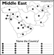
Middle East
In this map of the Middle East worksheet, students study the map of the Middle East and then write the names of the 20 countries on the provided lines.
Curated OER
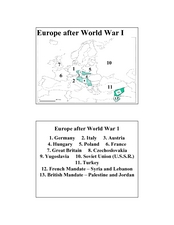
Europe after World War I
In this Europe after World War I map worksheet, learners note the 11 regions of the Europe labeled on the map.
Curated OER
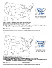
Mystery State # 39
Which state will be the answer to the five clues today? After considering each clue, learners will name the mystery state. If your class can determine which state was home to Chief Sitting Bull, they'll be able to answer South Dakota.
Curated OER
The Hispanic World
Go on an electronic field trip. Discover Spanish-speaking countries through Internet exploration. Students participate in a whole group discussion to general knowledge about the location, cultural background, independence and current...
Environmental Education in Wisconsin
Biome Travel Guide
In a perfect marriage of social studies and science, groups work together to research and create a travel guide presentation to share with the class. Not only do kids learn about the climate and geography of a biome, but also the...
Peace Corps
Celebrating Our Connections Through Water
Water is vital for survival, but how does it help global cultures flourish? Elementary and middle schoolers learn about the different cultures around the world that celebrate water and incorporate it into their festivals or traditions.
National Museum of the American Indian
The A:Shiwi (Zuni) People: A Study in Environment, Adaptation, and Agricultural Practices
Discover the connection of native peoples to their natural world, including cultural and agricultural practices, by studying the Zuni people of the American Southwest. This lesson includes examining a poster's photographs, reading...
Curated OER
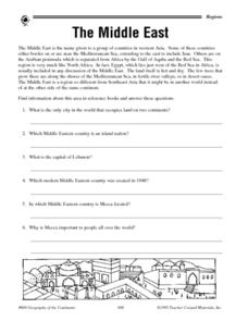
The Middle East - Regional Research
In this geography learning exercise, student read a short blurb about The Middle East as a region of the world before conducting further research. They complete 10 short answer questions, and complete a 15 question activity in which they...
Curated OER
MAISA and the REMC Association of Michigan
Students complete online research to study geography's impact on weather. In this geography and weather lesson, students research weather in their city for ten days using an online website. Students bookmark the site, enter data into a...
Curated OER
Magnetic Volcanoes
Students research on world maps active volcanoes, those that have erupted recently as well as the dormant ones. They assess the conditions on Earth and how volcanoes erupt and then create an erupting volcano with magnets and a cookie...
Curated OER
Santa Lucia Crown
Young scholars identify the countries, Sweden, Norway, Denmark, Finland, and Italy, that celebrate Saint Lucia Day and locate them on a world map. They research the Christmas holiday customs in these countries and represent their...
Curated OER
Tropical Island
Young scholars research information about a specific tropical island and locate it on a world map. They study details about coral reefs and other animal and plant life on the island and determine how ocean currents affect the island's...
Curated OER
What Came From Where?
Students research patterns and networks of economic interdependence. They work cooperatively to create 3-dimensional representations of common objects and charts describing the objects' components and countries of origin. Students...
Luminations Media Group
Geography: Map Reading Basic Skills
Enhance scholars' map skills using this worksheet displaying the land of Kahitsa’an from the series, The Realm, by K.L. Glanville. The activity helps readers visualize the make believe-land, examine its attributes, and answer...
Curated OER
Geothermal Energy in Latin America
Here is a wonderful series of lessons designed to introduce learners to the variety of renewable, clean energy sources used by people all over the world. Geothermal energy is the resource focused on. This particular sources of energy...
K-State Research and Extensions
Water
How are maps like fish? They both have scales. The chapter includes six different activities at three different levels. Scholars complete activities using natural resources, learn how to read a map, see how to make a compass rosette,...
Curated OER
Itaipu Dam and Power Plant (Brazil and Paraguay)
Learners study South America's Itaipu Dam and Power Plant in order to gain an understanding that hydroelectric power is a major means of generating electricity throughout the world. They also look into the environmental impacts that...
Curated OER
How Many Ways Can You Say Merry Christmas?
Students create a multicultural holiday bulletin board map! students research and study saying Merry Christmas in different languages. They correctly locate the countries on a world map.
Curated OER
Capturing the Reader With Vivid Images
Students examine how the author tries to capture the reader's imagination immediately, through imagery--and hold on to it. They locate Ukraine on a world map and understand Lenin's role in the establishment of Russian communism and the...
Other popular searches
- World War I Map
- Mapping Penny's World
- Map of the World
- World Outline Maps
- Blank Maps of World
- World War 2 Map
- World War 1 Maps
- World War I Outline Map
- Map of World
- World Climate Map
- Blank World Outline Maps
- World Biomes Map

