Curated OER
World: Political Map
In this world political outline map worksheet, students examine boundaries of each of the countries in the world. This map not is labeled.
Curated OER
Africa: Political Map
Students create a political map for Africa. In this country identification lesson, students locate Africa on a globe and discuss some of its major countries and bodies of water. Students complete a political map of Africa and...
Curated OER
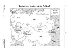
Central and Northern Asia: Political
For this Central and Northern Asia map worksheet, students examine national political boundaries and national capitals in this region of the world. The map is labeled.
Curated OER
World: Continents Map
In this outline map worksheet, learners note the political boundaries of the continents of the world. The map is labeled with the names of the 7 continents.
Curated OER
Central America Outline Map - Labelled
In this Central American political map worksheet, students make note of national boundaries and capitals in this region of the world. National capital city locations are noted with stars.
Curated OER
Asia and the South Pacific : Political Map
In this Asia and the South Pacific map worksheet, students examine the boundaries of the nations in this region of the world. Students also note the location of capital cities as they are denoted by stars. Major bodies of water are labeled.
Curated OER
Introduction to the World Globe
Learners examine a globe and the world map to see what constitutes the differences. In this world map introductory lesson plan, students discuss what they see when they view the globe. Learners then, look at a world map and compare the...
Curated OER
Waldseemuller's Map: World 1507
Students investigate the 1507 word map. In this world geography lesson, students examine the details of each section of the map and then draw conclusions about how the people of 1507 understood the world. Students are evalated on...
Curated OER
Waldseemüller’s Map: World 1507
Students take a closer look at historical maps. In this primary source analysis lesson plan, students examine the first world map produced by Martin Waldseemuller. Students complete the included map analysis worksheet and then write...
Curated OER
South east Asia and the South Pacific: Political: Labeled Map
In this Asia and the South Pacific map worksheet, students examine the boundaries of the nations in this region of the world. Students also note the location of capital cities as they are denoted by stars. This map is labeled.
Curated OER
Rivers, Maps, and Math
Middle schoolers use maps to locate and label the major rivers of North and South America. Using the internet, they identify forests, grasslands, mountain ranges and other landforms on the continents as well. They compare and contrast...
Curated OER
Hemispheres & Continents
Students learn in cooperative learning groups to determine how the equator and the Prime Meridian divide the earth into hemispheres and use Venn diagrams. Students will locate and label the hemispheres, continents, and oceans.
Curated OER
Hungary: The Landscape
Students work in small groups to create a topographic map of Hungary. The map will include labeled line drawing of the bordering countries. Hungary should be three dimensional, made of salt and flour clay. The mountains, plains and...
Curated OER
European Union Governance
Become familiar with the structure and functions of the European Union. As they conduct internet research, young historians use an attached worksheet to categorize the five main institutions of the EU. A flowchart worksheet also gives...
Curated OER
Physical and Human Geography Review Worksheet and Study Guide
In this geography skills activity, students respond to 30 short answer questions pertaining to physical and human geography.
Curated OER
Mesoamerica
Young scholars demonstrate knowledge of early Middle American civilizations. They study Mesoamerican i religions, governments, and achievements. They identify geographies of North and South America.
Curated OER
Splendid China
Sixth graders gain an appreciation for the traditions and vast contributions of the Chinese culture in this unit of lessons.
Curated OER
Nunavut, Our Communities
Students research the Online Atlas of Canada to locate the communities of Nunavut. Students examine the geographic area and characteristics of the communities.


