Curated OER
Orienteering - Lesson 2 - Topographical Maps
One of the most important skills in orienteering is being able to read a topographical map. Understanding the contour lines and symbols and the scale of the map will make planning your route so much better. In this lesson plan, partners...
Curated OER
What Do Maps Show?: Lesson 4 How to Read a Topographic Map
Students examine the use of topographic maps as two dimensional representations that show elevations and slopes with contour lines. They read maps of the Salt Lake City, Utah area and complete the associated worksheets that show map...
Curated OER
Mapping the Aegean Seafloor
Earth science learners create a two-dimensional topographic map of the floor of the Aegean Sea. They use it to then create a three-dimensional model of the ocean floor features. This comprehensive resource delivers strong background...
Curated OER
Introducing Topographic Maps: Guiding Students from Concrete Models to Graphic Representations
Students interpret topographic maps and infer human activity as it is influenced by the landscape.
Curated OER
Topo Map Mania!
Students read and use topographical maps. They also use a compass to find bearing to an object on a map and in the classroom. Ask your students how they might travel to somewhere they have never been to befo
Curated OER
Introduction To Topographic Map Activities
Students discuss different types of maps, their similarities and differences. Using a Topographical Maps CD-rom program students create their own map.
Curated OER
Fossil Fuels (Part II), The Geology of Oil
More of a mini-unit than a lesson plan, these activities lead inquisitors through a survey of oil deposits. In the first part, they read about and view diagrams of sedimentary rock layers that trap oil. Next, they test porosity and...
Curated OER
"Potato Mountain": Reading/Understanding Topographic Maps
Students investigate how to read topographic maps. For this map reading lesson students complete a topographic map activity.
Curated OER
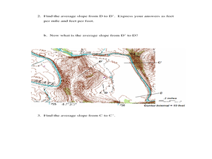
Slope and Topographic Maps
Students investigate slopes as they study topographic maps. In this algebra instructional activity, students discuss and apply the concept of slopes to graphing and analyzing data.
Curated OER
River Study
Students explore a stream in their area and show the class the topographic map of the stream. They locate the topographic map and name the streams, lakes and ponds in their watershed. They write a paragraph about their stream and...
Curated OER
Watershed Investigations
Students explore the components of a watershed and the factors that affect it. They read a topographical map and use geometry to determine the area of a watershed. Students estimate the volume of a body of water and perform runoff...
Curated OER
Map Lesson Plan
Fourth graders locate and label major sites related to the Revolutionary War in the Hudson River Valley. They examine topographical features of each site and list a few of these features and list two advantages of each military site.
Alabama Learning Exchange
WATER You Doing to Help?
Auntie Litter is here to educate young scholars about water pollution and environmental stewardship! Although the 15-minute video clip is cheesy, it's an engaging look at the water cycle and conservation. Learners start by illustrating...
Curated OER
Candy Bar Subsurface Geology
Students are introduced to drawing and interpreting topographical maps. They each cut through there Jell-o mountain at regular height intervals, and trace around the shape of the Jell-o cut off at the height, overlaying the different...
NOAA
Into the Deep
Take young scientists into the depths of the world's ocean with the second lesson of this three-part earth science series. After first drawing pictures representing how they imagine the bottom of the ocean to appear, young scholars...
Curated OER
River Study
Students study physical features of a local stream. They study how to identify water features on topographic maps.
Curated OER
Science Excursion: Cover Mapping Land
Students study remotely sensed images and topographic maps to classify land cover types in their watershed area. They take samples in the watershed area to interpret the images.
Curated OER
Mapping the Sea Floor
Students review their prior knowledge on topographical maps. Using a map, they examine the sea floor off the coast of San Diego, California. With a partner, they chart the sea floor of an area and use cutouts to create a visual...
Global Change
Impact of Climate Change on the Desert Pupfish
A fish that lives in the desert? You and your class can meet the desert pupfish as they examine its habitat, the role humans play in diminishing water supplies, and how climate change might impact this fishy friend. There are four short...
Curated OER
PA Watersheds, Many Ways to the Sea
Students examine the water cycle and the factors that interact with watersheds. In this watersheds activity students describe the purification process, trace the flow of infiltrate water through aquifers, and research the Internet...
Curated OER
The Delicate Balance - Iowa's Natural Resources
Discover the natural resources in Iowa by studying it's history. In this environmental lesson, your young scholars will observe a topographical map of Iowa and identify where its most valuable resources are. They complete an Iowa name...
Curated OER
Geologic Mapping I
Students create a geologic map and cross-section of an area of horizontal sedimentary rocks, exposed in several locations. Map must include a complete key or legend with rock descriptions of the various formations.
Curated OER
Cookie Mapping
Students study the components of a bedrock geology map through a hands-on activity involving a cookie and graph paper.
Curated OER
Stranded along the Coast
Students plot stranding sites onto a map using latitude and longitude as well as compass directions with respect to coastal features. They identify several species of marine animals that might become stranded; distinguish their...


