New York State Education Department
US History and Government Examination: August 2011
Using primary source documents, pupils consider how the United States' democratic story has evolved over time. A second essay question examines the role of geography in history, and multiple-choice questions sharpen test-taking skills.
Owl Teacher
Latitude & Longitude
Here is a worksheet activity where learners mark the latitude and longitude coordinates of cities all over the world. There are 15 cities to identify, from Baghdad, Iraq to Warsaw, Poland and Anchorage, Alaska.
Happy Housewife
State Notebooking Pages
When learning about US geography, it can hard to remember facts about 50 different states. Help your young scholars organize all of this information with a collection of easy-to-use note-taking guides.
Curated OER
States & Capitals 1-25
Young pupils test their geography skills by matching the 50 states to their correct state capitals. The states are listed in alphabetical order on the left, and a list of state capitals are presented in random order in a right-hand...
Polar Bears International
Top of the World
Learn about polar bears and the Arctic circle with a lesson about the countries and conditions of the region. After examining how the area differs from Antarctica, kids explore climates, animals, and geographical position...
Concord Consortium
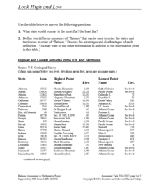
Look High and Low
From the highest high to the lowest low here's a resource that won't fall flat. Given data on the area and the highest and lowest elevations of each of the 50 states, learners decide which states are the least flat and the most flat. Of...
PBS
Pbs Learning Media: Molly of Denali: Fish Camp Game
Use this Molly of Denali digital game to extend and expand students' use of informational text as well as their knowledge of Alaska Native culture.


