Hi, what do you want to do?
American Battlefield Trust
American Battlefield Trust: Civil War: Animated Map: Fort Sumter
Animated map tells the story of the events that led up to the first shots of the Civil War fired at Fort Sumter. [7:31]
University of Georgia
University of Georgia: Hargrett Library Rare Map Collection: American Civil War
This collection of rare Civil War maps enhance the study and learning of the Civil War. They provide a wealth of insight into the war and helps to better understand the events that occurred. A great resource for teachers and an exciting...
University of Virginia
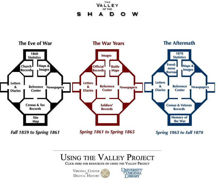
University of Virginia Library: The Valley of the Shadow
Analyze the Civil War through a multitude of primary source documents. This comprehensive site chronicles the Civil War in Virginia from its roots to the battles, and finally the consequences of this divisive war. Read letters and...
Library of Congress
Loc: Civil War Maps: History of Mapping the Civil War
Investigate the importance of mapping to both the Union and the Confederates in planning their military strategy. From the Library of Congress.
Library of Congress
Loc: Civil War Maps
The Library of Congress provides a large collection of maps dating back to the Civil War. The collection consists of reconnaissance, sketch, coastal, and theater-of-war maps which depict troop activities and fortifications during the...
University of North Carolina
Unc University Libraries: Digital Collections: Gilmer Civil War Map Collection
A large collection of Civil War maps of the south, mostly North Carolina and Virginia. The collection can be searched by state or key word.
American Battlefield Trust
American Battlefield Trust: Civil War: Animated Map: Chantilly
Animated map shows the troop movements of both the Union and Confederate armies prior to and during the battle at Chantilly, in Virginia, in 1862.
American Battlefield Trust
American Battlefield Trust: Civil War: Animated Map: Franklin
Animated map shows the troop movements of both the Union and Confederate armies prior to and during the Civil War battle at Franklin, Tennessee, in 1864.
American Battlefield Trust
American Battlefield Trust: Civil War: Animated Map: Cedar Creek
Animated map tells the story and shows the troop movements of both the Union and Confederate armies prior to and during the battle fought at Cedar Creek, Virginia, 1864.
American Battlefield Trust
American Battlefield Trust: Civil War: Chancellorsville May 1, 1863
This map tells the story and shows the troop movements of both the Union and Confederate armies on the first day of battle at Chancellorsville, Virginia, in 1863. The map can be downloaded in PDF format.
American Battlefield Trust
American Battlefield Trust: Civil War: Battlefield Land We've Saved
A U.S. map depicts historic land where Civil War battles were fought that has been saved by the Civil War Trust. It also presents current campaigns to save more land.
Other
Vox: 37 Maps That Explain the American Civil War
April 1865 was a momentous month in American history. On April 9, the Confederate army under Robert E. Lee surrendered to the Union forces of Ulysses S. Grant, effectively ending the Civil War. Then on April 14, the victorious President...
American Battlefield Trust
American Battlefield Trust: Civil War: Maps of Chickamauga, Georgia (1863)
Animated map of the Battle of Chickamauga brings the Civil War to life with footage of the battlefield, map, and explanation.
Library of Congress
Loc: Civil War Maps: History of Mapping the Civil War
A detailed, thorough account of commercial map making during the Civil War. Site contains a propaganda map for the Anaconda Plan, encircling the South.
Curated OER
Historical Maps: Civil War 1861 1865
A very interesting map that shows the area under Union control in 1861 and the subsequent land lost by the Confederacy to the Union year by year. From the Perry-Castenada Collection.
University of Georgia
University of Georgia: Hargrett Library Rare Map Collection: The Historical War Map, 1862
A large map of the U.S. in 1862 showing the roads and railways primarily in the Confederacy.
University of Georgia
University of Georgia: Hargrett Library Rare Map Collection: Topical War Map of the Southern States
A large detailed map of the central and southern U.S. from 1863. Difficult to read.


