Curated OER
Magnetic Earth
In this magnetic Earth worksheet, learners learn how a compass works with the magnetic poles of the Earth. This worksheet has 4 short answer questions.
Curated OER
Topo Map Mania!
Seventh graders describe the major features of maps and compasses. They read a topographical map. They take a bearing using a compass. They practice using scales on a map.
Curated OER
Magnet Mania
Young scholars explore magnetic fields. In this science instructional activity, students create a magnetic field using electricity. Young scholars observe the effect of a magnetic field on the compass needle.
Curated OER
Making Shapes
Tenth graders construct geometric figures using compasses and protractors.
Curated OER
Using Four Main Directions in the Classroom
Students identify the four cardinal directions. In this map skills geography lesson, students use a magnetic compass to label the four directions in the classroom. Students use the four directions to locate objects in the classroom.
Curated OER
Magnetic Mapping
Students draw arrows to show the direction the compass needle is pointing when it is placed around different points of a penny and a bar magnet. Students must then answer questions about the activity on a provided worksheet.
Curated OER
Using 4 main directions in a classroom
Learners use the four directions of a compass rose to locate classroom features. In this directions lesson plan, students locate the features by identifying directions.
Curated OER
Ticky Goes to Jr. Map School
First graders sing "We All Live Together," by Greg and Steve. They look at a map and sing the "Soggy Waffle Song" to study about the compass rose. Students write N, E, S, W on the borders of paper that goes under a 100's chart. The...
Curated OER
Let's Build
Students observe and discuss a picture of Curious George building a bridge and discuss what it means to build, plan and design a project. As a class, they list things they need to do in oder to build something and explore how a compass...
Curated OER
Angles and Turns
In this angles activity, students solve 24 problems in which angles and measurements on a compass are calculated. There are also some map problems to solve. The page is intended for online use but can be done on paper.
Curated OER
Using the Four Main Directions in the Classroom
Students utilize a compass to determine where North is in the classroom. In this direction lesson, students label the four main directions. Students locate features in the classroom and describe the directions to get to them. Students...
Curated OER
How to Teach Geography with KidPix 1
Students create a compass rose. In this geography lesson, students create a compass rose using the computer program KidPix 1.
Curated OER
Drawing a Bird's Eye View Map
Students make birds-eye view maps and place the compass rose on the map.
Curated OER
Weather Conditions During the Spring Monarch Migration
Middle schoolers keep detailed weather records during the spring migration of the monarch butterfly. To keep track of the weather, students utilyze weather reports and instuments such as anemometers, compasses, thermometers and rain gauges.
Curated OER
Second Graders on the Map
Second graders explore the various types of maps. They examine the differences between street maps and aerial photographs. Students identify various features on each map. They use cardinal directions and the compass rose. They write...
Curated OER
Lesson Design Archaeology- World Map
Students practice locating positions on the world map. In this map skills lesson, students explore the world map and items such as the compass rose, Equator, mountains, cities, etc. The students practice locating positions on the world...
Curated OER
Magnetic Insulators
In this magnetic insulators worksheet, students use magnets, a compass, paper and more to observe magnetic force. Students then answer 3 questions.
Curated OER
Mapping It Out
This PowerPoint provides information about maps. Students discover the functions of legends, compasses, indexes, and scales on maps. Two resources links are provided, however one of them is broken.
Curated OER
Magnetism
Attract your class to magnetism with this straightforward presentation. Using bullet points and simple phrases, viewers are taught the basics of magnetism. There are no pictures or diagrams to help explain, so you might want to add a few...
Curated OER
Our States, My State
Students examine the Louisiana state quarter and locate Louisiana on a map of the U.S. They relate the location of Louisiana to other states (and vise versa) using directions and the compass rose.
Curated OER
Motions and Forces
Sixth graders investigate the construction of a magnet and the force it produces. They identify various materials as magnetic or non-magnetic, discuss the properties of magnetic properties, and conduct an experiment with a compass and...
Curated OER
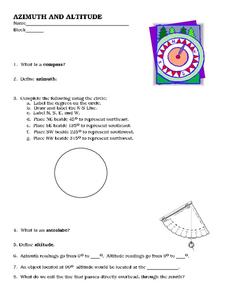
Azimuth and Altitude
In this altitude worksheet, students define compass, azimuth, astrolabe, and altitude. Students use a protractor to determine the altitude of the given stars on a graph. This worksheet has 7 short answer questions and 8 fill in the blank...
Curated OER
A School Map
In this school map instructional activity, students practice their map reading skills as they use the word box and the compass rose the help them answer 6 fill in the blank questions.
Curated OER
Magnets
In this magnets worksheet, students use magnets and a compass to investigate the magnets. Students write down 5 discoveries that they make about their magnets.


