Curated OER
Wikipedia: Natl Historic Landmarks in Montana: Great Northern Railway Buildings
These lodges or associated buildings, dated c.1913-1915, represent European-style hostelries unique among NPS concessions. The landmark contains 5 building groups: Granite Park Chalet, Many Glacier Hotel, Sperry Chalet, Two Medicine...
Curated OER
Wikipedia: National Historic Landmarks in Montana: Lake Mc Donald Lodge
A Swiss chalet-style hotel in Glacier National Park.
Curated OER
Wikipedia: National Historic Landmarks in Montana: Northeast Entrance Station
Rustic entrance station built in 1935 that is a prime example of form fitting function, in Yellowstone National Park.
Curated OER
Wikipedia: National Historic Landmarks in Montana: Chief Plenty Coups Home
The 2-story house of Crow Nation chief Plenty Coups during 1884-1932, plus a log store and the Plenty Coups Spring.
Curated OER
Wikipedia: National Historic Landmarks in Montana: Fort Benton
Established as a fur trading center in 1847, the fort prospered with the growth of steamboat traffic starting in 1859 and an 1862 gold strike, but declined with the advent of the railroad.
Curated OER
Wikipedia: National Historic Landmarks in Montana: Pompey's Pillar
The massive natural block of sandstone was a major landmark on the Lewis and Clark Expedition. Clark's signature is carved on its surface.
Curated OER
Wikipedia: National Historic Landmarks in Montana: Butte Historic District
One of the largest and most notorious copper boomtowns in the American West; the district includes more than 6,000 contributing properties.
Other
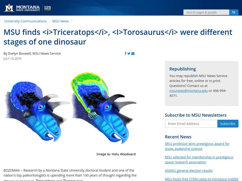
Msu News: Msu Finds Triceratops, Torosaurus Were Different Stages of Dinosaur
Two paleontologists from Montana State University, John Scannella and Jack Horner, discuss their newly released theory that Triceratops and Torosaurus were actually the same dinosaur but at different stages of their life cycle. [Date of...
Georgia Department of Education
Ga Virtual Learning: The Way to Rainy Mountain by N. Scott Momaday [Pdf]
This is a five-page PDF of the introduction to The Way to Rainy Mountain by N. Scott Momaday, a book about Momaday's Kiowa ancestors' journey from their ancient beginnings in the Montana area to their final war and surrender to the US...
PBS
Pbs Learning Media: Fire Cloud
Firefighters fight a raging fire on a wild horse range in Montana in this video segment from Nature.
PBS
Pbs Learning Media: 50 States Part 2 Lesson Plan
In this activity, learners combine psychomotor skills and geography as they travel from Montana to Wyoming. As students travel from state to state, they learn regional facts and state capitals. Learners perform physical tasks...
Other
Montana State Univ.: Expanding Universe (Lesson Plan)
This site has a lesson plan in which students gather evidence supporting the Big Bang Theory using a balloon model of the expanding universe.
Curated OER
Educational Technology Clearinghouse: Maps Etc: Lewis Mountains, 1911
A contour map of part of the Lewis Mountains of western Montana, representing typical glacial features of the range.
Curated OER
Educational Technology Clearinghouse: Maps Etc: Northern Rockies, 1911
A map of the northern Rockies in Montana showing the mountain systems, ranges, and intermontane trenches of the area.
Curated OER
Educational Technology Clearinghouse: Maps Etc: Boulder Plateaus, 1911
A contour map from 1911 of the topography of East and West Boulder plateaus and the northern end of the Absaroka Range in southwestern Montana.
Curated OER
Educational Technology Clearinghouse: Maps Etc: Highwood Mountains, 1911
A contour map showing the topography of the Highwood Mountains, Montana. The contour intervals are 200 feet.
Curated OER
Educational Technology Clearinghouse: Maps Etc: Highwood Mountains, 1911
A map of a part of the Highwoods Mountains in Montana showing a glaciated portion of the Great Plains. The map shows the remnant glacial features such as moraine and drift, and shows the areas covered by younger drift, areas covered by...
Curated OER
Educational Technology Clearinghouse: Maps Etc: Little Belt Mountains, 1911
A contour map showing the topography of Montana's Little Belt Mountains.
Curated OER
Etc: Maps Etc: Great Plains and Front Ranges, 1911
A contour map of the boundaries of the Great Plains and Lewis front ranges of western Montana, showing the abrupt change in the topography. The heavy black line indicates the outcrop of the Lewis thrust plane.
Curated OER
Montanakids.com: Crow Indian Reservation
The Crow Reservation is located in south-central Montana. This is a brief history of the Crow tribe that call themselves the Apsaslooka.
Other
Trail Tribes: Traditional and Contemporary Native Culture
An excellent resource on the tribal groups located along the trails followed by explorers Lewis and Clark. Each group has a section devoted to its modern and historical cultures, as well as the tribe's relationship with the United States...
Discovering Lewis & Clark
Discovering Lewis & Clark: The 'Great' Falls
This section of Discovering Lewis & Clark examines the 'Great Falls' which the expedition had to portage around during the westward leg of their 1805-06 exploration of the Louisiana Purchase.
Other
Combined Arms Research Library: Atlas of the Sioux Wars:
An in-depth look at the Sioux Wars from 1862-1877. Included are maps for many topics discussed.
University of California
Ucmp: Adventures at Dry Creek
For this lesson, students embark on an adventure to find out what life was like in Montana 60-70 million years ago. Students "join" a research lab to collect fossils from Montana and analyze them to find direct and indirect evidence of...
Other popular searches
- Montana 1948
- Hannah Montana
- Individuality Montana 1948
- Montana History
- Montana 1948 Worksheets
- 12 Tribal Nations of Montana
- Acrostic Poem About Montana
- Montana Indians
- Montana Tribe
- Montana Quarter
- Natural Resources Montana
- +Montana 1948


