BBC
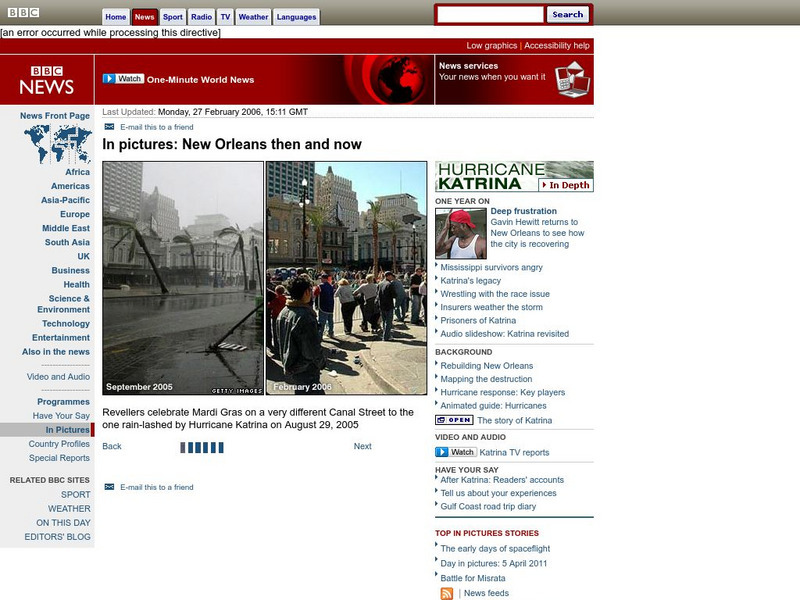
Bbc: In Pictures: New Orleans Before and After
Vivid slideshow of photographs of New Orleans during the flooding by Hurricane Katrina and two months later.
BBC
Bbc: In Pictures: New Orleans Then and Now
Photographic slide show that allows you to compare areas of New Orleans in September 2005 with the city a year later in 2006.
Other
Virtual Picture Travel Map of New Orleans
Click on New Orleans and take a virtual tour. See the French Quarter. Visit places of interest such as Lafayette No. 1 Cemetery, St. Louis Cathedral and Bourbon Street. Due to the interactive nature of this site, it may take loner than...
Other
Virtual Picture Travel Map of New Orleans
Click on New Orleans and take a virtual tour. See the French Quarter. Visit places of interest such as Lafayette No. 1 Cemetery, St. Louis Cathedral and Bourbon Street. Due to the interactive nature of this site, it may take loner than...
University of Georgia
University of Georgia: British Attack on New Orleans (1815)
The original 1815 battle plan of the British forces used in their attack on the American forces at New Orleans is visible on this map.
Curated OER
Bbc: Rebuilding New Orleans
New Orleans considers how to rebuild the levee system that was devastated by Hurricane Katrina. Maps of New Orleans and the levee system are available. Article is from January, 2006.
Curated OER
Bbc: Rebuilding New Orleans
New Orleans considers how to rebuild the levee system that was devastated by Hurricane Katrina. Maps of New Orleans and the levee system are available. Article is from January, 2006.
Curated OER
Sea Level Sign Near New Orleans Convention Centre
An October, 2005, update on the reconstruction of the devastated New Orleans levees. The levees failed during Hurricane Katrina causing the city of New Orleans to flood.
Curated OER
Bbc: Fixing New Orleans' Thin Grey Line
An October, 2005, update on the reconstruction of the devastated New Orleans levees. The levees failed during Hurricane Katrina causing the city of New Orleans to flood.
Curated OER
Flooded New Orleans
Graphic and photographic slideshow that shows how the failed New Orleans levees are repaired.
Curated OER
Bbc: Hard Task of Draining New Orleans
September, 2005, article tracing the draining of the flooded New Orleans and the repairing of the levee system devastated by Hurricane Katrina.
CNN
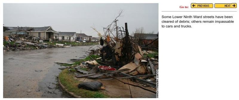
Cnn: Ninth Ward, Six Months Later
Captivating photo slideshow that shows a section of New Orleans six months after Hurricane Katrina. The damage in the photos is obvious.
Curated OER
Educational Technology Clearinghouse: Maps Etc: Vicinity of New Orleans, 1872
A map from 1872 of the vicinity of New Orleans. "New Orleans, now the capital of the state of Louisiana, is on the E. bank of the Mississippi River, 105 miles from its mouth, by the river's course. It was first settled by the French in...
Curated OER
Etc: Maps Etc: From New Orleans to the Gulf, 1862
A map of the Mississippi River from New Orleans and Lake Pontchartrain to the mouth on the Gulf of Mexico. The map shows the location of Forts Jackson and St. Philip, two Confederate forts essential to the protection of New Orleans,...
Curated OER
Educational Technology Clearinghouse: Maps Etc: New Orleans, 1901
A city plan from 1901 of New Orleans showing the major streets, neighboring municipalities, and the proximity of Lake Pontchartrain and Mississippi River.
Curated OER
Educational Technology Clearinghouse: Maps Etc: New Orleans, 1919
A map from 1919 of the vicinity of New Orleans and the Mississippi Delta showing the State capital of Baton Rouge, neighboring towns, railroads, lakes, rivers, and coastal features of the region.
Curated OER
Educational Technology Clearinghouse: Maps Etc: New Orleans, 1862
A map of New Orleans and the Mississippi Delta at the time of the American Civil War, showing the railroads in the area, and the strategic Confederate forts St. Philip and Jackson. These forts were a first line of defense for the city...
Curated OER
Educational Technology Clearinghouse: Maps Etc: Plan of New Orleans, 1903
A plan from 1903 of the city of New Orleans, showing roads, the Mississippi River, and important landmarks. Landmarks indicated on the map include the: City Hall, Custom House, Mint, U.S. Courts, U.S. Marine Hospital, St. Louis...
Curated OER
Educational Technology Clearinghouse: Maps Etc: Environs of New Orleans, 1903
A map from 1903 of the Mississippi Delta region showing the site of New Orleans, Lake Pontchartrain, Lake Borgne, and the course of the Mississippi River through the bird's-foot delta to the Gulf of Mexico.
Curated OER
Educational Technology Clearinghouse: Maps Etc: Vicinity of New Orleans, 1916
A map from 1916 of the Mississippi River Delta from New Orleans and Lake Pontchartrain to the mouth of the river on the Gulf of Mexico. The map shows railroads, swamp lands, navigation lights, and water depths in fathoms. The 3, 10, 20,...
Curated OER
Educational Technology Clearinghouse: Maps Etc: New Orleans and Vicinity, 1909
A city plan from 1909 of New Orleans showing the major streets, canals, railroads, neighboring municipalities, major landmarks, and the proximity of Lake Pontchartrain and Mississippi River.
Curated OER
Etc: Maps Etc: Battle of New Orleans, January 8, 1815
A map of the area around the Mississippi Delta and western Florida showing the battle site near New Orleans during the War of 1812. Although no territory was gained after the war, conditions were set in place for the cession of Florida...
Other popular searches
- Battle of New Orleans
- New Orleans Musicians
- Battle for New Orleans
- New Orleans Jazz
- New Orleans History
- New Orleans Katrina
- New Orleans Music
- Celebration in New Orleans
- New Orleans Clean Up
- Carnivals in New Orleans
- New Orleans Mardis Grass
- New Orleans Mar Dis Grass


