Houghton Mifflin Harcourt
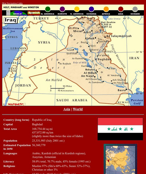
Holt, Rinehart and Winston: World Atlas: Iraq
Find all the basic data on Iraq on this page. Contains a clear map from "MapQuest", flag and facts in a list format. Categories include languages, religions, life expectancy, currency, GDP, industry, agriculture and more.
Houghton Mifflin Harcourt
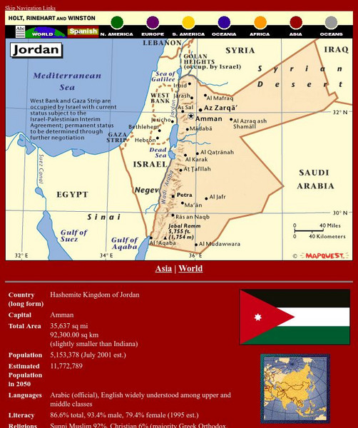
Holt, Rinehart and Winston: World Atlas: Jordan
Find all the basic data on Jordan on this page. Contains a clear map from "MapQuest", flag and facts in a list format. Categories include languages, religions, life expectancy, currency, GDP, industry, agriculture and more.
Houghton Mifflin Harcourt
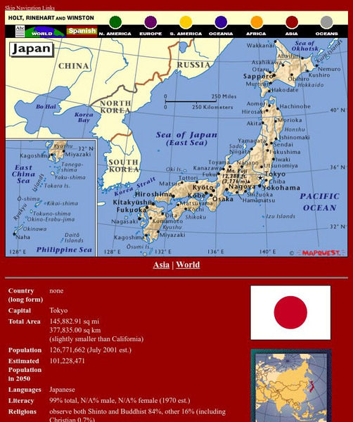
Holt, Rinehart and Winston: World Atlas: Japan
Find all the basic data on Japan on this page. Contains a clear map from "MapQuest", flag and facts in a list format. Categories include languages, religions, life expectancy, currency, GDP, industry, agriculture and more.
Houghton Mifflin Harcourt
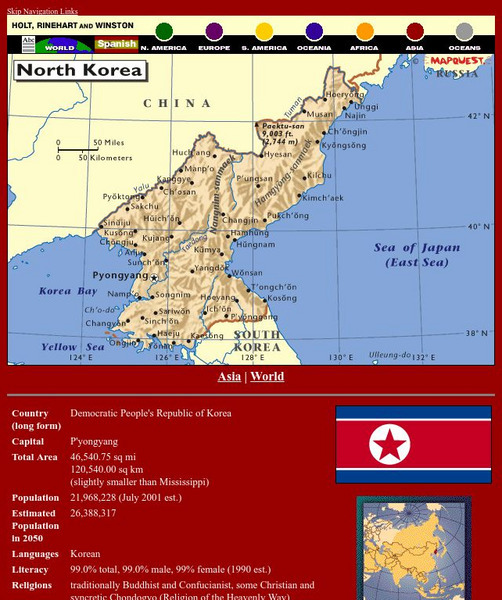
Holt, Rinehart and Winston: World Atlas: North Korea
Find all the basic data on North Korea on this page. Contains a clear map from "MapQuest", flag and facts in a list format. Categories include languages, religions, life expectancy, currency, GDP, industry, agriculture and more.
Houghton Mifflin Harcourt
Holt, Rinehart and Winston: World Atlas: Peru
Find all the basic data on Peru on this page. Contains a clear map from "MapQuest", flag and facts in a list format. Categories include languages, religions, life expectancy, currency, GDP, industry, agriculture and more.
University of North Carolina
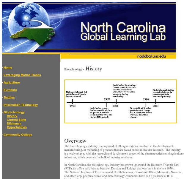
University of North Carolina: History of Biotechnology in North Carolina
The biotechnology industry is comprised of all organizations involved in the development, manufacturing, or marketing of products that are based on bio-molecular research. The industry is closely aligned with the research and development...
Houghton Mifflin Harcourt
Holt, Rinehart and Winston: World Atlas: Iran
Find all the basic data on Iran on this page. Contains a clear map from "MapQuest", flag and facts in a list format. Categories include languages, religions, life expectancy, currency, GDP, industry, agriculture and more.
Houghton Mifflin Harcourt
Holt, Rinehart and Winston: World Atlas: Israel
Find all the basic data on Israel on this page. Contains a clear map from "MapQuest", flag and facts in a list format. Categories include languages, religions, life expectancy, currency, GDP, industry, agriculture and more.
Curated OER
Educational Technology Clearinghouse: Maps Etc: North China, 1971
" North China includes the densely populated and intensively cultivated North China Plain, the loess-covered uplands of Shansi, northern Shensi, and eastern Kansu, and the sparsely populated, semiarid steppes of Inner Mongolia....
Curated OER
Educational Technology Clearinghouse: Maps Etc: South America, 1898
A map of South America in 1898. The map shows capitals and major cities, railroads, terrain, rivers, and coastal features, and includes an insert map of the Isthmus of Panama. "The chief industries in South America are herding,...
Curated OER
Educational Technology Clearinghouse: Maps Etc: South China, 1971
"South China comprises the drainage basins of the middle and lower Yangtze River, the basin of the His Chiang (West River) in Kwangtung and Kwangsi; and the mountainous coastal provinces of Fukien and Chekiang. The division between the...
Curated OER
Educational Technology Clearinghouse: Maps Etc: Economic Map of Europe, 1915
A map from 1915 of Europe showing the principal agricultural and mining districts in the region. The map shows principal cities, railroads, and rivers, and is keyed to show areas of wheat, barley, wine, silk and flax production. The...
Curated OER
Etc: Maps Etc: Economic Activity in North America, 1916
A map from 1916 of North America showing the economic production areas of the region. This map is color-coded to show industrial districts, productive, and non-productive regions. The map shows the principal extraction areas for coal,...
Curated OER
Educational Technology Clearinghouse: Maps Etc: Kansas, 1904
A map from 1904 of Kansas showing the State capital of Topeka, major cities and towns, railroads, and rivers. "Kansas (Garden of the West) - Organized as a Territory in 1854; made a State in 1861. Area, 82,080 square miles; population,...
Curated OER
Etc: Maps Etc: Industry of the British Isles, 1914
A map from 1914 of the British Isles showing the areas of commercial production including agricultural, fishery, mineral, and manufacturing products. The coalfields of the islands are shown as shaded areas. Major cities, rivers, and...
Curated OER
Educational Technology Clearinghouse: Maps Etc: Economic Map of Europe, 1910
A map showing the chief industries and industrial districts, coal fields, agricultural and fishing districts, major cities, navigable rivers and principal railways throughout Europe in 1910. Chief industries are indicated by letter, with...
Curated OER
Educational Technology Clearinghouse: Maps Etc: Industrial Map of Europe, 1915
A map from 1915 of Europe showing the principal industrial districts in the region. The map shows principal cities, railroads, and navigable rivers, and is keyed to show the chief industrial districts, agricultural and stock-rearing...
Curated OER
Maps Etc: Increasing Distance From Lumber Producers to Lumber Consumers, 1920
A map of the United States from the U. S. Department of Agriculture (1922) showing the increasing distance lumber had to travel to go from the production areas in the south and west to the consumption areas in the east. The map shows...
Curated OER
Educational Technology Clearinghouse: Maps Etc: Idaho, 1904
A map from 1904 of Idaho showing the capital of Boise City, counties, towns, railroads, mountain systems, lakes, and rivers. "Idaho was created as a Territory in 1863. Admitted to statehood in 1890. Gold discovered in 1860. Area, 84,290...
Curated OER
Unesco: Spain: Palmeral of Elche
The Palmeral of Elche, a landscape of groves of date palms, was formally laid out, with elaborate irrigation systems, at the time the Muslim city of Elche was erected, towards the end of the tenth century A.C., when much of the Iberian...
Curated OER
Unesco: Ecuador: Historic Centre of Santa Ana De Los Rios De Cuenca
Santa Ana de los Rios de Cuenca is set in a valley surrounded by the Andean mountains in the south of Ecuador. This inland colonial town (entroterra ), now the country's third city, was founded in 1557 on the rigorous planning guidelines...
