Other
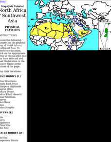
Harper College: North Africa/ Sw Asia Map Tutorial
Quiz yourself on the physical geography of Southwest Asia and North Africa by using this tutorial to Check your knowledge of landforms, bodies of water, and rivers in this area of the world.
Curated OER
Educational Technology Clearinghouse: Maps Etc: Physical Map of Europe, 1916
A physical map of Europe from 1916 showing color-coded elevations and water depths for the area extending from Iceland to the natural boundary between Europe and Asia (Ural Mountains to the Caspian Sea), and the Arctic Circle to the...
Curated OER
Educational Technology Clearinghouse: Maps Etc: Physical Asia, 1882
A map from 1882 showing the physical features of Asia. This map is color-coded to show high lands in buff tints and low plains in green. Mountain systems, tablelands, and plains are shown, as well as major rivers, lakes, and coastal...
Curated OER
Educational Technology Clearinghouse: Maps Etc: Asia (Physical), 1868
A map from 1868 of Asia showing physical features and natural resources of the region. The map shows political boundaries of the time, with capitals, major cities, and ports. The map shows mountain systems with black lines of variable...
Curated OER
Educational Technology Clearinghouse: Maps Etc: Asia (Physical), 1901
A map of Asia from 1901 showing the physical features of the region including mountain systems, plateaus, basins, plains, deserts, lakes, rivers, and coastal features and islands. The map shows major ocean currents, the mean annual...
Curated OER
Educational Technology Clearinghouse: Maps Etc: Asia (Physical), 1915
Asia, showing major landforms and waterways, including the Arabian Desert; the Tibetan Plateau and Himalayas, the Gobi Desert, the China Lowlands, Hwang-ho River, Song-ka River, et cetera.
Columbia University
Asia for Educators: Outline Maps
The outline maps are designed to be used as transparencies that can be overlaid on an overhead projector to demonstrate the diversity of China's physical and cultural geography. Copies can be printed out and reproduced also for student...
Curated OER
Educational Technology Clearinghouse: Maps Etc: Physical Europe, 1916
A physical map of Europe from 1916 showing color-coded elevations and water depths for the area extending from Iceland to the Ural Mountains in Russia Proper, and the Arctic Circle to the Mediterranean Sea. Land elevation colors range...
Curated OER
Educational Technology Clearinghouse: Maps Etc: Physical Greece, 1600 265 Bc
A physical map of Greece and the Aegean Sea, showing Greek territories in Asia Minor. This map shows the rivers, mountain terrain, coastal features, and islands of the region.
Curated OER
Educational Technology Clearinghouse: Maps Etc: Physical Asia, 1910
A map from 1910 of Asia, showing physical features and general elevations. This map uses color-contours to show land elevations ranging from below sea level around the Caspian Sea to over 6,500 feet, and water depths from sea level to...
Curated OER
Educational Technology Clearinghouse: Maps Etc: Physical Asia, 1916
A map from 1916 of Asia, showing physical features and general elevations. This map uses color-contours to show land elevations ranging from below sea level around the Caspian Sea to over 15000 feet, and water depths given in fathoms....
Curated OER
Etc: Maps Etc: Physical Asia With Isotherms, 1916
A map from 1916 of Asia, showing physical features, general elevations, and mean isotherms for January and July. This map uses color-contours to show land elevations ranging from below sea level around the Caspian Sea to over 12000 feet,...
Curated OER
Etc: Maps Etc: Physical and Political Asia, 1870
A map of Asia from 1870 showing country boundaries at the time, major cities, mountain systems, rivers, lakes, deserts, terrain, and coastal features. An inset map details the area of Palestine, and an outline map of Pennsylvania at the...
Curated OER
Educational Technology Clearinghouse: Maps Etc: Natural Regions of Asia, 1920
A map from 1920 of Asia showing principal physical features and natural regions. The map is color-coded to show lands below sea level, lowlands, uplands and plateaus, the older, worn down mountains, and younger, rugged mountains. The map...
Curated OER
Etc: Maps Etc: Physical, Political, and Economic Asia, 1872
A map of Asia from 1872, showing physical features including mountain systems, deserts, lakes, rivers with direction of flow, coastal features, and ocean currents, political boundaries and foreign possessions at the time, and commercial...
Curated OER
Educational Technology Clearinghouse: Maps Etc: Europe, 1901
A map from 1901 of Europe, showing the political boundaries at the time, capitals and other major cities, mountain and terrain features, lakes, rivers ,islands, and coastal features of the region. The physical division between Europe and...


