Core Knowledge Foundation
Year 2: Northern Europe
How is life in Northern Europe different from other areas of the world? Historians journey through the various regions of Northern Europe discovering what type of climate, animals, and lifestyles exist in that section of the world. They...
Curated OER
Where to Look for the USA?
Fifth graders, in groups, explore the the type of reference sources are needed to answer a question. Each group identifies where the material was located, and the teacher records the guess.
Curated OER
Grid Skills
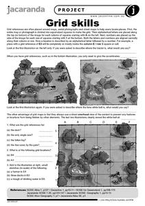
In this geography instructional activity, students use grid references on a map to locate places in the pictures given. They also identify another advantage of using a grid map, which they have an overhead view of the content to prevent...
Curated OER
Interesting Place Names 1
In this geography learning exercise, students analyze 24 names of villages and towns in England, Scotland and Wales. Students use an atlas for reference and mark the ten fake names.
Curated OER
Creating a Map for Future Reference
Students use Web and other resources to create maps of either the site of their day trip, their final destination, the entire trip, or some combination of these.
Curated OER
Latitude and Longitude
Learners find latitude and longitude on a map or atlas. They create maps with a cruise route. They practice plotting locations given latitiude and longitude.
Curated OER
Recognizing Reference Sources
Fourth graders investigate five different reference sources in the Media Center: Atlas, Dictionary, Encyclopedia, Card Catalog (Look Up Station), and the Internet. They decide which is the BEST source to use to answer specific questions.
Curated OER
Particulate Observation Lab
Students collect samples of common dust from their homes and school for examination under a microscope. They identify the components of their samples using the provided "Atlas of Indoor Dust Particles." Pupils take samples form a variety...
Curated OER
Where in the World War? Mapping WWII in the Pacific
Learners explore the Pacific Theatre of War. In this World War II lesson, students use reference material to access information about significant locations in the Pacific Theatre of War. Learners identify the locations of the listed...
Curated OER
Native Knowledge
Students investigate what type of climate and physical features certain Indigenous groups live in using an atlas and a provided worksheet. They then match the tribe and its location to the sustainable stategy employed in agricultural...
Curated OER
Give Me Some Latitude
In this latitude activity, students use an atlas or other reference to respond to 4 multiple choice questions about the equator and the poles.
Curated OER
One Grain at a Time
Students investigate deserts. In this geography activity, students create a KWL chart about deserts and research information on deserts by using reference books. Students record the characteristics of deserts and the wildlife which lives...
Curated OER
The Middle East- Geography
Students discover the geography of the Middle East. In this geography lesson, students use reference books and the Internet to research the geography of the Middle East. Students complete an activity sheet to match the capital cities...
Curated OER
Map of the Ottawa Valley
Students locate Ottawa Valley on a map. They then answer questions in reference to the map such as: What was the first use of timber in the Ottawa Valley?, What occurred first in Gatineau?, and On the Ontario side of Ottawa River, how...
Curated OER
Populations in the Path of Natural Hazards
Students read "Geographical Mobility: 1995-2000." They examine the maps in the handouts and compare them with maps from an atlas. In the second part of this lesson, students read "In Harm's Way." They receive three more handouts, one a...
Ball State University
Dear Pen Pal
Keep your class in conversation with others across the country or across the sea by writing letters to pen pals. The activity calls for students to be pan pals with pupils in Africa; however, the listed steps could be used for any...
Curated OER
Nunavut, Our Communities
Students research the Online Atlas of Canada to locate the communities of Nunavut. Students examine the geographic area and characteristics of the communities.
Curated OER
From North to South...Quebec's Forest Regions
Students identify and describe the different regions of Canada. With a focus on the forest regions, they use an atlas to locate the ecozones. They identify the characterstics of the climate and vegetation and the relationship between...
Owl Teacher
Five Themes of Geography Research Activity
Here is an activity worksheet that will prompt your young geographers to choose a country anywhere in the world to research and study, and to then apply it to the five themes of geography.
Curated OER
Research Project
Eighth graders research a project of their choice in relation to a career they may want. In this language arts lesson, 8th graders create a bibliography of references used both print and online sources. Students make an outline of their...
Curated OER
Location of Cities 201
Students work in pairs to locate the ancient cities on a world atlas using the longitude and latitude measurements. They examine the physical and human futures that explain their locations.
Curated OER
Create a Dichotomous Key of Idaho Reptiles
Students use the reptile section of the Digital Atlas of Idaho. They make a dichotomous key and decide on what defining characteristics they can use to distinguish between species. They hone their observation skills and recognize...
Curated OER
The World Through Art
Students create a multimedia report comparing a favorite form or work of art with those from other cultures around the world. In small groups they research the cultural influences on art in different regions of the world using an Encarta...
Curated OER
Tribal Termination & Urbanization
Students list the main events in historical sequence of tribal termination and urbanization. They identify a present-day American Indian experience or phenomenon as a result of termination and urbanization and refer to 'Navajo...


