Curated OER
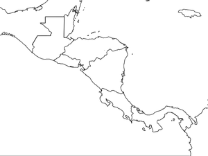
Central America Map wtih Country Borders
In this blank outline map activity, students explore the political boundaries of Central America and the nations there. This map may be used in a variety of classroom activities.
Curated OER
South America Outline Map
In this blank outline map worksheet, students explore the political boundaries of South America and the nations there. This map may be used in a variety of classroom activities. The location of the capital cities are denoted with...
Curated OER
Europe Map
In this blank outline map worksheet, students explore the political boundaries of the continent of Europe. This map may be used in a variety of classroom activities.
Curated OER
Africa Outline Map
In this outline map worksheet, students discover and investigate the continent of Africa and the political boundaries of its nations. This blank outline map may be used for a variety of classroom activities.
Curated OER
South American Outline Map
In this blank outline map worksheet, students study the political boundaries of the continent of North America and those of the countries located there.
Curated OER
European Map
In this blank outline map activity, students explore the political boundaries of the continent of Europe and those of the countries located there.
Curated OER
Europe Outline Map (Labled)
In this blank outline map worksheet, students study the political boundaries of the labeled European nations.
Curated OER
Australia Map
In this blank outline map worksheet, students explore the political boundaries of Australia. This map is labeled and may be used in a variety of classroom activities.
Curated OER
Australia Map: Labeled
In this blank outline map worksheet, students explore the political boundaries of Australia and its provinces and territories. This map is labeled and may be used in a variety of classroom activities.
Curated OER
Map Keys
Third graders examine maps and map keys. In this locating map features lesson plan, 3rd graders use crayons, markers and colored pencils to label maps. Students work in partners to read map keys and locate given places and things.
Curated OER
North America Outline Map
In this blank outline map instructional activity, students investigate the political boundaries of the continent. This map may be used for a variety of classroom activities.
Curated OER
Europe Outline Map
In this blank outline map worksheet, learners explore the political boundaries of the continent of Europe and those of the countries located there.
Curated OER
A world of oil
Learners practice in analyzing spatial data in maps and graphic presentations while studying the distribution of fossil fuel resources. They study, analyze, and map the distribution of fossil fuels on blank maps. Students discuss gas...
Curated OER
United States Map
Students describe cities they are familiar with. In this United States Map lesson, students understand how cities are listed on a map. Students become aware of a map legend and the information in it.
Curated OER
Romania
In this blank outline map instructional activity, students explore the political boundaries Romania located in Europe. This map may be used in a variety of classroom activities.
Curated OER
Geography of Canada
All about Canada! Learners explore the geography and providences of Canada by watching videos, studying maps and conducting internet research. By the end of this lesson, your class should be able to locate major areas and compare and...
Curated OER
NATO Geography & Language
The class receives background information on NATO, an atlas, and a blank world map. They color the original 1949 countries in red, the 1952 additions in green, and the 1990 additions in blue. This exercise would be a good starting point...
Edline
How Did the Unification of Germany Change the Course of World History?
Here you'll find a nice guided notes worksheet on Otto von Bismarck, which details Bismarck's plan to unify Germany, as well as asks learners to analyze his motivations and overall impact.
Curated OER
Mapping the Middle East
Students examine how the countries of the Middle East were created. They explore the influence of various political and geographic factors in their creation. They list the things they should consider in deciding how to draw new borders...
Curated OER
World: Continents
In this blank outline map worksheet, students note the political boundaries of the continents of the world on a Robinson projection map.
Annenberg Foundation
Revolutionary Perspectives
Life, liberty, and the pursuit of happiness. Learners go to the heart of the causes of the American Revolution. Examining political cartoons, Enlightenment documents, and firsthand accounts, they present their ideas and reflective...
Curated OER
Geography of Vietnam
Ninth graders examine the geography of Vietnam. In this Geography lesson, 9th graders create a physical and political map of Vietnam.
Curated OER
Geography of Spain
Students explore Spain. In this geography skills lesson, students investigate a political map of Spain and record the names of states, capitals, and landforms. Students then practice tagging the states, capitals, and landforms on blank...
Curated OER
Hemispheres & Continents
Students learn in cooperative learning groups to determine how the equator and the Prime Meridian divide the earth into hemispheres and use Venn diagrams. Students will locate and label the hemispheres, continents, and oceans.


