Laboratory for Atmospheric and Space Physics
Charting the Progress of New Horizons
In 2006, New Horizons began its mission to fly to Pluto. As it continues its journey, scholars track its progress with the help of an informative website, all the while reinforcing measurement concepts with the construction of a scaled...
PBS
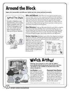
Around the Block
Arthur and his friends help children explore the concepts of family, community, and diversity in a fun series of activities. From performing peer interviews to mapping out the different places students have lived or visited, this...
Curated OER
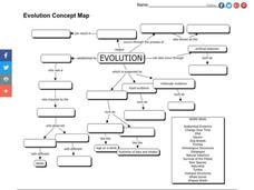
Evolution Concept Map
In this evolution concept map worksheet, 7th graders use the vocabulary terms related to evolution to complete the evolution concept map.
Tech Know Teaching
6th Grade Constructed Response Question
Graphs, charts, maps, diagrams. Reading and comprehending informational text is far more than just decoding the words on a page. Here's a packet that provides young readers with practice answering constructed response questions using...
K-State Research and Extensions
Water
How are maps like fish? They both have scales. The chapter includes six different activities at three different levels. Scholars complete activities using natural resources, learn how to read a map, see how to make a compass rosette,...
Curated OER
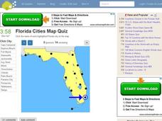
Florida Cities Map Quiz
In this online interactive geography learning exercise, students examine a map of Florida and identify the 12 noted cities on the map using a pull down menu within 3 minutes.
Curated OER
Texas Cities Map Quiz
In this online interactive geography worksheet, students examine a map of Texas and identify the 15 noted cities on the map using a pull down menu within 3 minutes.
Curated OER
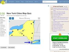
New York Cities Map Quiz
In this online interactive geography worksheet, students examine a map of New York and identify the 11 noted cities on the map using a pull down menu within 3 minutes.
Curated OER
South America Map Quiz
For this online interactive geography quiz worksheet, students examine the map that includes all of South America's countries. Students identify the 13 countries in 2 minutes.
Curated OER
Middle East Map Quiz
In this online interactive geography quiz learning exercise, students examine the map that includes 26 Middle Eastern countries. Students identify the names of the countries in 4 minutes.
Curated OER
Central America Map Quiz
In this online interactive geography quiz worksheet, students examine the map that includes 22 Central American countries. Students identify the names of the countries in 3 minutes.
Curated OER
California Cities Map Quiz
In this online interactive geography quiz worksheet, students examine the map that includes 12 California cities. Students identify the names of the cities in 3 minutes.
Curated OER
Canada Map Quiz
In this online interactive geography quiz worksheet, students examine the map that includes 13 Canadian provinces and territories. Students identify the names of the provinces and territories in 2...
Conneticut Department of Education
Instructional Strategies That Facilitate Learning Across Content Areas
Imagine 28 instructional strategies, appropriate for all subject areas and all grade levels. Directed Reading-Thinking Activities (DRTA), Question-Answer Relationship (QAR) activities, KWL charts, comparison matrixes, classification...
Curated OER
United States Map Quiz
In this online interactive geography quiz worksheet, students respond to 50 identification questions about the shapes of countries shown. Students have 5 minutes to complete the quiz.
Curated OER
Pictures of Data
In this data worksheet, learners look at maps and charts and answer multiple choice questions about them. Students complete 10 questions.
Curated OER
Pictures of Data: Post Test
For this data worksheet, students answer multiple choice questions about charts and graphs. Students answer 10 questions total.
Curated OER
Interpreting Statistics: A Case of Muddying the Waters
Is river pollution affecting the number of visitors to Riverside Center, and is the factory built upstream the cause of the pollution? Let your class be the judge, literally, as they weigh the statistical evidence offered by the factory...
Mathed Up!
Negative Numbers
Individuals read tables with temperatures and times in order to distinguish the town with the lowest temperature or most extreme temperature difference. Each of the eight questions has three sub-questions that use the same charts.
Curated OER
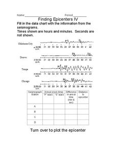
Finding Epicenters
In this earthquake learning exercise, students use the seismographs from different locations to determine the epicenter for the earthquake. Students plot the epicenter on a map. This learning exercise has 1 graphic organizer.
Curated OER
Hopeful Eyes on Southern Skies
The Times covered a drought in 2011, which affected producers, consumers, and sellers. The class gets informed about climate and the economics of agriculture as the read this article and answer each of the 11 comprehension questions. A...
University of California
Energy and Biomass Pyramids
Young scientists play tag as they act out the food pyramid in the ocean ecosystem. Energy circles pass from the smaller prey to the predators and at the end of the activity, a data chart and analysis questions allow pupils to apply their...
Curated OER
Be A Cartographer
In this be a cartographer worksheet, students read about the history of cartography, make a map of a familiar place, share it with a friend and answer 2 questions about their friend's map.
Curated OER
Oceania Map Quiz
In this online interactive geography quiz learning exercise, learners respond to 14 identification questions about Oceania. Students have 2 minutes to complete the quiz.
Other popular searches
- Maps and Charts
- Analyze Maps and Charts
- Reading Maps and Charts
- Ireland Maps and Charts
- Tables, Maps and Charts
- Maps Graphs and Charts
- Maps, Charts, Globes
- Interpreting Charts and Maps
- Tables Maps and Charts
- Graphs, Charts and Maps
- Graphs\, Charts and Maps
- Word Maps and Charts

