Other
Western Oregon University: Earth System Science: Geologic Time [Pdf]
An 81-page slideshow that looks at the principles of geology with respect to relative dating, at different concepts describing geological processes, at absolute age and radiometric dating, at the eons and eras in the geologic time scale,...
University of California
University of California Museum of Paleontology: Distribution in Time and Space
The Understanding Evolution site provides evidence for evolution in biogeography utilizing relative dating, geography, and plate tectonics.
Other
World Time Zone: Map With Current Time
See a map of the whole world with the current time given for each time zone. Also, find time zone maps of selected areas, countries observing daylight saving time, a sun clock showing the day/night areas of the world, and what the time...
Other
Time & Life Pictures: Defining Visions of an Enduring History
This database of images contains hundreds of photographs from TIME and Life Magazines from a span of over 70 years. This is a wonderful resource for the study of history, culture or photojournalism. Images are searchable by photographer,...
Georgia Department of Education
Ga Virtual Learning: Time Periods [Pdf]
The date, historical context, genre/style, content, and effect of several different time periods including: Puritan Times, Rationalism/Age of Enlightenment, Romanticism, Realism, Modernism, and Contemporary/Postmodernism.
US Navy
Usno: Daylight Time
From the U.S. Naval Observatory, a brief history of daylight savings time including information of the passage of the Energy Policy Act of 2005 which changed the date from the first Sunday in April to the second Sunday in March starting...
Fundación Cientec
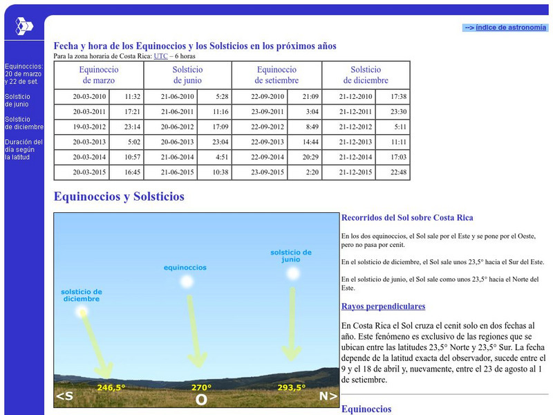
Cientec: Equinoccios Y Solsticios
Read about equinoxes and solstices. You will also find a table with date and time of the future equinoxes and solstices in the coming years.
Other
Mt. Vernon Ladies' Association: Washington's "First 100 Days"
A "President's First 100 Days" has become a barometer by which to measure the success of the rest of his term. George Washington had the added weight of launching our new nation in his first 100 days. Use this interactive timeline to see...
NASA
Nasa: Rockets Educator Guide: A Pictorial History
View pictures, descriptions, and dates of rockets throughout history. Learn about rockets and how they have evolved throughout time.
Classical Net
Classical Net: Timeline of Famous Composers 1600 to Present
PDF document showing composers in various musical eras from the Baroque period to modern times.
Boston College
Becker Collections: Drawings of the American Civil War
The Becker Collection showcases the drawings and observations of artist-reporters who worked for "Frank Leslie's Illustrated Weekly Newspaper," a newspaper of the time. Find a visual record of the war along with other drawings that...
University of Utah
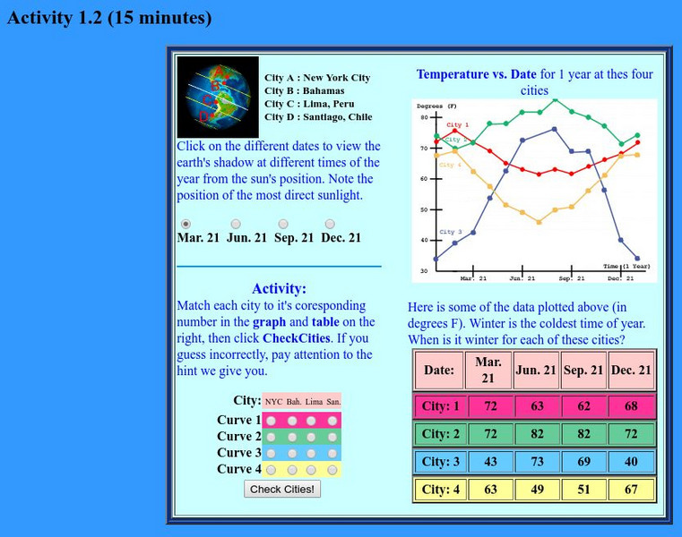
University of Utah: Aspire: Seasons Exercise
In this activity, use seasons to determine your location. Click on the different dates to view the earth's shadow at different times of the year from the sun's position.
Other
The Stoa Consortium: Acropolis: The East Slope
The East Slope of the Acropolis is an area that has not (yet) been the focus of a great deal of archaeological investigation. Early travelers and explorers noted, of course, the very large and prominent East Cave that forms such a...
Curated OER
Unesco: Spain: Palmeral of Elche
The Palmeral of Elche, a landscape of groves of date palms, was formally laid out, with elaborate irrigation systems, at the time the Muslim city of Elche was erected, towards the end of the tenth century A.C., when much of the Iberian...
Curated OER
Educational Technology Clearinghouse: Maps Etc: United States, 1821
A map of the United States and territories in 1821 after the Missouri Compromise, showing the Free States and territories, the Slave States and territories, and the transitional territories at the time. The map is color-coded to show the...
Curated OER
Etc: Territorial Development of the United States, 1783 1889
A map from 1889 of North America showing the expansion in the region of the United States from the original Thirteen Colonies at the end of the Revolutionary War in 1783 to the time the map was made, around 1889, before the territories...
Curated OER
Educational Technology Clearinghouse: Maps Etc: Northeast China, 1971
"Northeast China - the provinces of Heilungkiang, Kirin, and Liaoning - is the most important region of the country and a nationally significant and still-developing center of agricultural production. Most of the Northeast remained...
Curated OER
Etc: Maps Etc: Africa Before the Berlin Conference, 1884
This is an interesting map of Africa showing the continent before the Berlin Conference of 1885, when the most powerful countries in Europe at the time convened to make their territorial claims on Africa and establish their colonial...
Curated OER
Educational Technology Clearinghouse: Clip Art Etc: Henry v of England
Henry V (16 September 1386 - 31 August 1422) was one of the most significant English warrior kings of the 15th century. He was born at Monmouth, Wales, in the tower above the gatehouse of Monmouth Castle, and reigned as King of England...
Curated OER
Educational Technology Clearinghouse: Maps Etc: Australia, 1885
A map of Australia in 1885 showing the states and territories of Australia at the time, including Nuyts Land, De Witt Land and Tasman Land in Western Australia, Arnhem land, Alexandra Land in North Australia, Queensland, South Australia,...
Curated OER
Educational Technology Clearinghouse: Maps Etc: North American Colonies, 1643
A map of the North American Colonies in 1643 at the establishment of the New England Confederation. The map is color-coded to show the territorial claims of the British, French, Dutch, and Swedish at the time, and shows the British...
Curated OER
Etc: The Territory of the Present Us During the French Indian Wars, 1755 1763
A map of North America showing the foreign possessions in the area of the present United States during the French and Indian Wars (1755-1763) between the French and English. This map is color-coded to show territorial claims at the time...
Curated OER
Etc: Maps Etc: South America Political Formation, 1911
A map from 1911 of South America showing the political boundaries of the time, major cities, terrain, rivers, and coastal features. The map is color-coded to show the Spanish, Portuguese, Dutch, and French possessions about the end of...
Curated OER
Unesco: Canada: Rideau Canal
The Rideau Canal, a monumental early 19th-century construction covering 202 km of the Rideau and Cataraqui rivers from Ottawa south to Kingston Harbour on Lake Ontario, was built primarily for strategic military purposes at a time when...
![Western Oregon University: Earth System Science: Geologic Time [Pdf] PPT Western Oregon University: Earth System Science: Geologic Time [Pdf] PPT](https://d15y2dacu3jp90.cloudfront.net/images/attachment_defaults/resource/large/FPO-knovation.png)


