Federal Reserve Bank
Federal Reserve Bank of Atlanta: Economic Systems
Helps students discover the three basic economic questions and how each system answers these questions, identify several key advantages and disadvantages for each economic system, recognize some economic indicators that can measure...
Other
Irena: How to Transform Energy System and Reduce Carbon Emissions
Information about renewable energy and how the world's energy system must continue to transform in order to combat climate change. Presents statistics about what different countries are doing to use more and more renewable energy...
Other
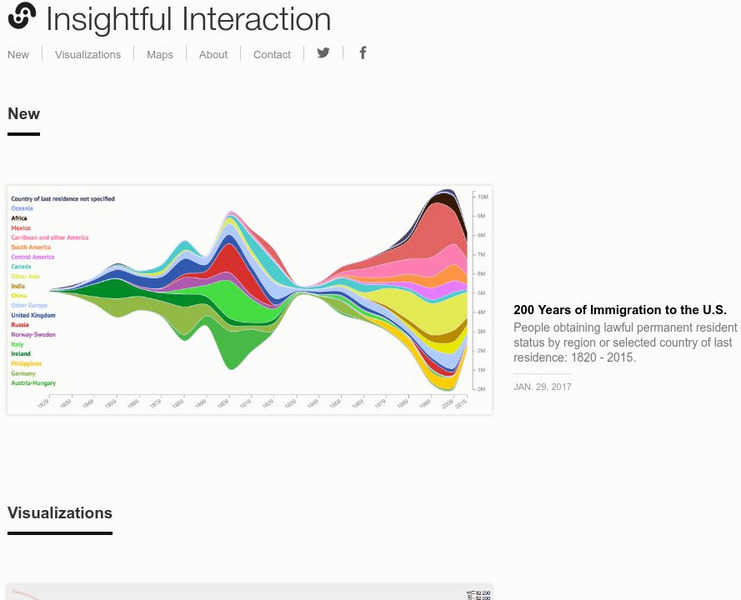
Insightful Interaction: Visualizations
A collection of interactive visualizations that were produced through analysis of economic, political, and market research data. Topics are diverse, e.g., military spending and trade, immigration, consumer spending, crime, unemployment,...
Other
Haines: Laptops Templates and Resources
Looking for ways to easily integrate technology into your classroom? This site lays out a template of 10 classroom sessions that effectively models use of laptops in the classroom. Units include a HS English research paper, health class...
Curated OER
Unesco: Italy: Genoa: Le Strade Nuove and the System of the Palazzi Dei Rolli
The Strade Nuove and the system of the Palazzi dei Rolli in Genoa’s historic centre date from the late 16th and early 17th centuries when the Republic of Genoa was at the height of its financial and seafaring power. The site represents...
Curated OER
Etc: Maps Etc: Physical, Political, and Economic Asia, 1872
A map of Asia from 1872, showing physical features including mountain systems, deserts, lakes, rivers with direction of flow, coastal features, and ocean currents, political boundaries and foreign possessions at the time, and commercial...
Curated OER
Etc: Maps Etc: Economic and Commercial Activity in the Philippine Islands, 1920
A map from 1920 of the Philippine Islands showing the principal commercial products in the region, with the products named in red. The map shows major cities and chief seaports, railroads, navigable rivers, islands and coastal features....
Library of Congress
Loc: Map Collections 1500 2002
This collection provides maps dating back to 1500 up to the present. The collection includes: cities, towns, discovery and exploration, conservation and environment, military battles, cultural landscapes, transportation, communication,...
Curated OER
Educational Technology Clearinghouse: Maps Etc: Northeast China, 1971
"Northeast China - the provinces of Heilungkiang, Kirin, and Liaoning - is the most important region of the country and a nationally significant and still-developing center of agricultural production. Most of the Northeast remained...
Curated OER
Unesco: Tanzania: Kondoa Rock Art Sites
On the eastern slopes of the Masai escarpment bordering the Great Rift Valley are natural rock shelters, overhanging slabs of sedimentary rocks fragmented by rift faults, whose vertical planes have been used for rock paintings for at...
Curated OER
Warm Air: Solar Heating
Solar heating systems and their operation are described, and their benefits, both economic and environmental are discussed in detail.
Curated OER
Unesco: Argentina: Jesuit Block and Estancias of Cordoba
The Jesuit Block in Cordoba, heart of the former Jesuit Province of Paraguay, contains the core buildings of the Jesuit system: the university, the church and residence of the Society of Jesus, and the college. Along with the five...


