Hi, what do you want to do?
Curated OER
Whose Business?
Fourth graders compare and contrast the businesses in Fort Griffin with those in their own community. Using the internet, they discover the factors that have influenced the development of businesses in a town. They also create a map of...
Curated OER
Geography And Chinese Landscape Painting
Fourth graders label the physical features of China on a map and become familiar with
the content of traditional Chinese landscape paintings in this lesson intended for the forth grade classroom.
Curated OER
Landscape Observation: How Portland Has Changed
Students read The Lorax and discuss how populations change the environment. Using given photos, students use a Venn Diagram to compare and contrast the Portland of yesterday to present day Portland. They write a comparison paper and...
Curated OER
"Across Oregon On The 45th N Parallel" A Transect of Oregon
Students explore the physical geography of Oregon. In groups, students collect weather and elevation information on Oregon. They organize the data and create maps and graphs of the information. Afterward, students compare the...
Curated OER
Where Is Hoku?
Students are introduced to map making and reading. Using maps, they identify the cardinal directions and discuss the importance of a legend. They analyze the human characteristics of the classroom and create overhead view maps of the...
Curated OER
Deforestation
Students identify the different tropical rainforests in the world using a map. In this ecology lesson, students describe the different methods of deforestation. They create a memo and present it to class.
Curated OER
Ocean Color
Students examine NASA's SeaWiFS Project Web site to explore how the SeaWiFS Project monitors environmental and climatic changes in the oceans and atmosphere. They answer questions and write a summary in support of continued funding for...
Curated OER
Flying High With Hot Air Balloons!
Sixth graders demonstrate an understanding of a narrative story by listening, speaking, reading and writing activities. They create two visual products that reflect the understanding of events, vocabulary, and characters.
Curated OER
African Safari
Sixth graders gain an appreciation for the different cultures that inhabit the Earth by focusing on the people of Africa
Curated OER
Alaska's Physical Systems and History
Students read about Alaska's physical systems and determine how Alaska's physical makeup has impacted its history. They create timelines of their particular physical system.
Curated OER
Northern Neighbors
Fourth graders research a province in Canada in order to compare and contrast Canada to our country. They create a HyperStudio production to display their findings.
Curated OER
Wright Brothers Centennial: North Carolina, Creation and Development of the State
Eighth graders examine technological advances and how they influenced the quality of life in North Carolina. Using maps, they locate the city of Kitty Hawk and discuss why it was chosen for the first flight. They read primary source...
Curated OER
WWII: On The Homefront and Abroad
Students explore World War II from the perspective of both the sides. They research the changes that occurred on the homefront during 1942-1944. Students prepare and conduct an interview with a local veteran or spouse of a veteran...
Curated OER
The Tilting Earth
Fourth graders use a styrofoam ball on a stick to represent earth and a light bulb in the center of the room to represent the sun. They walk around the light, holding their sticks at an angle to show the tilt of the earth's axis. They...
Curated OER
Mongolia Geography
Students examine the geography and culture of Mongolia. Individually, they cut out cut-outs of animals to place on their maps and label the grasslands and desert areas. They locate major cities and rivers along with vegetation.
Other
Australian Landforms and Their History
A history of the formation of the Australian continent, along with descriptions of many of Australia's unique features. Links to the geographical features of Australia are provided, such as highest mountains, islands, or longest rivers.
Scholastic
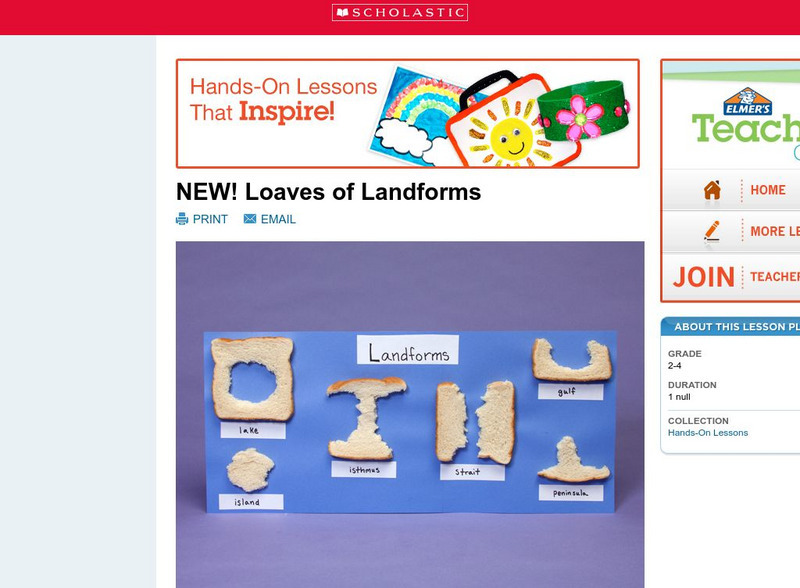
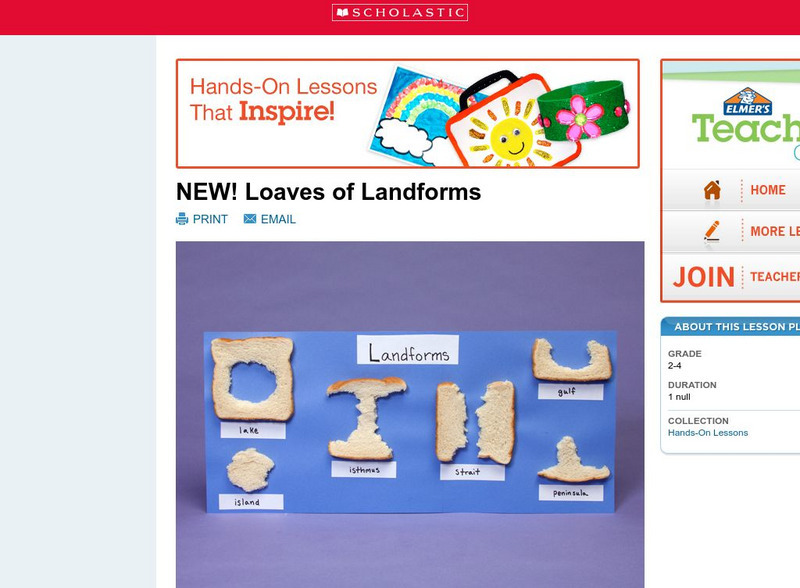
Scholastic: Loaves of Landforms!
A foundation in geography begins with an understanding of the terms geographers use to describe the features of Earth. This lesson plan is designed to help young scholars grow their vocabulary and learn to recognize common landforms in a...
National Geographic
National Geographic: Mapping Landforms
Students will study landform maps of states and then create a project of their own.
National Geographic
National Geographic: Shaping the Tallest Peak on Earth
This lesson builds upon a National Geographic film covering George Mallory's effort to climb Mount Everest in 1924. It looks at the physical features of mountains, and the landform features of Mount Everest that present challenges to...
Science Struck
Science Struck: Types of Landforms
Describes different landform types and their features. includes many good quality photographs.
Scholastic
Scholastic: Loaves of Landforms
This is a comprehensive lesson plan to teach primary students about landforms. A foundation in geography begins with an understanding of the terms geographers use to describe the features of Earth. Help students grow their vocabulary and...
Enchanted Learning
Enchanted Learning: The Continents
Brightly colored printouts, maps, and graphics on the greatest land masses on earth. See how continental drift works, look up extremes, label maps, learn about latitude, longitude and other geography terms. Teachers will find a Landforms...
ClassFlow
Class Flow: How Landforms Affect Settlers' Choices
[Free Registration/Login Required] This flipchart has students engage in a research project looking at how geographical features affected the colonists' settling of the New World. Web links to aid the research process are included. An...
NASA
Nasa Earth Observatory: Changing Global Land Surface
Learn how scientists view the changes in the land surface made by humans over time. Read questions that scientists pose to answer some unknown questions about global land surface and learn several things scientists are doing to try to...


