Curated OER
Our 50 States
Students identify the location of the 50 states using an interactive map. They practice geography skills by playing a fun game. Pupils become familiar with the state abbreviations for the US states. Students become familiar with the...
Curated OER
The Seven Continents Scavenger Hunt
Who doesn't enjoy an engaging scavenger hunt? Here, scholars listen to, and discuss, the informative text, Where is my Continent? by Robin Nelson. They then explore the seven continents and four major oceans using Google Earth.
Montana State University
Meet Mount Everest
Learning about one landform might seem boring to some, but using the resource provided practically guarantees scholar interest. The second in a sequential series of eight covering the topic of Mount Everest includes activities such as a...
Curated OER
THE TRAVELS OF BABAR: An Adventure in Scales
Students locate and identify the seven continents. They use longitude and latitude in establishing a location. Students enhance the knowledge of geographical location with cultures. Individuals or small groups research multiple aspects...
Curated OER
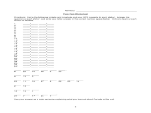
Canada Eh? Pre/Post Tests on Canada Using GPS
Young scholars participate in a GPS activity and answer questions about Canada. In this Canada lesson, students identify location by using a GPS Unit and latitude and longitude. Young scholars find an Inuksuk (station) and a complete...
Curated OER
Tear the Continents
Learners tear paper into representative continent shapes and configure them with world oceans through relative location, direction and latitude and longitude starting points. They recognize the shape of the continents. Students recognize...
Curated OER
The Sounds of Samba
Students research the origins of Samba in Brazil using the internet. After defining new vocabulary, they locate the cities in Brazil using latitude and longitude which practice the Samba. In groups, they compare and contrast the...
Curated OER
Tectonic Plates, Earthquakes, and Volcanoes
Challenge geography classes to locate the major volcanoes and earthquake faults on a world map. In groups, they identify the pattern made and examine the relationship between the locations of the faults and volcanoes and tectonic plates....
Curated OER
Oh Canada!!
Fifth graders become familiar with the people, culture, government and geography of Canada. In this Canadian people and places instructional activity, 5th graders research and create a map of Canada reflecting their gathered...
Curated OER
Unit 1 Review for Global History 9
Ninth graders review what they know about river valley civilizations. In this global history instructional activity, 9th graders play Cave Jeopardy to prepare for an exam on Sumeria, Egypt, Indus, and Chinese civilizations.
Curated OER
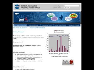
Creating Climographs
Students use satellite data to compare precipitation and surface temperatures on different islands. For this satellite lesson students create graphs and explain the differences between weather and climate.
Curated OER
Is Portland, Oregon Experiencing Global Warming?
Students use data to determine if the climate in Portland has changed over the years. In this weather lesson students complete line graphs and study long wave radiation.
Curated OER
Solar Cell Energy Availability From Around the Country
Students determine areas that are the most likely to produce solar energy by using NASA data. In this solar energy lesson students analyze plots and determine solar panel use.
Curated OER
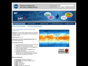
Earth's Energy Budget - Seasonal Cycles in Net Radiative Flux
Students attempt to understand seasonal variation by viewing images of the energy received by the earth. In this weather lesson, students view images from NASA of the influx of energy from the sun and make predictions about resulting...
Alabama Learning Exchange
The Sun and the Earth
Third graders study and diagram the positions of the Earth and sun during the four seasons. They predict weather for cities in the northern and southern hemispheres.
Curated OER
Plotting Earthquakes
Learners explore earthquakes. Using the National Earthquake Information Center website, students plot daily earthquakes on a map. They observe the magnitude of each earthquake. Learners identify the pattern of earthquake locations and...
Curated OER
Are We Falling Apart? Exploding Volcanoes
Students research and demonstrate volcanic activity. In this volcanism lesson, students research the types of volcanoes and define related terms using the Internet. They demonstrate volcanic activity with water, corn syrup, and flour.
Curated OER
The Earth Moves Under My Feet
Learners study earthquakes, monitor seismic activity using the Web, and plot real-time activity. They examine movement of the Earth's tectonic plates. They create an earthquake preparedness project.
Curated OER
Maps
Maps, globes, and computer software aid young explorers as they locate state capitols, major cities, geographic features, and attractions for states they are researching. They then use desktop publishing software to create a map to share...
Curated OER
Absolute Location Using GPS Technology
GPS is great for identifying your position, but is it finding your relative or absolute location? Ninth graders explore the difference between absolute and relative location, use the standard grid system coordinate system, and use GPS to...
Curated OER
LAND USE ISSUES
Students relate math with real life situations. They identify and plot points on a grid map. They identify and locate the Drop Box Sites.
Curated OER
Mapping Plate Boundaries
Students discover plate boundaries based on the uneven geographic occurrence of geologic hazards. After discussing geologic hazards, students plot different sets of earthquakes and volcanic eruptions on maps.


