Curated OER
Nunavut, Our Communities
Students research the Online Atlas of Canada to locate the communities of Nunavut. Students examine the geographic area and characteristics of the communities.
Curated OER
How Do You Get To Korea?
Students examine the differences between Korea and the United States. In groups, they identify the physical and political characteristics of Asia and discuss how the geographic features in Korea affect the activities performed there. ...
Curated OER
Letters From Rifka
Students demonstrate their understanding of how people feel when they are forced to leave their homes and countries. This is done while students read and reflect upon reading letters sent by students from other countries.
Curated OER
On the Road Again": Moving People, Products, and Ideas
In this lesson students learn how to identify modes of transportation and communication for moving people, products, and ideas from place to place. Students also study the advantages and disadvantages of different modes of...
Curated OER
Lâlâkea Stream: Diversion and Restoration
Students research the history of the Lalakea stream diversion and restoration. They examine the restoration project from multiple viewpoints and consider how it affects the stream-related environments.
Curated OER
Art Around the World
Eleventh graders explore the art styles of different cultures by researching and then creating a "museum exhibit".
Curated OER
Negotiating Treaties
Eleventh graders recognize the interaction between early settlers and indigenous people in the U.S. They recognize the impact of the Indian Removal Act on displaced Natives in the early West and the impact on Native attitudes today.
Curated OER
Living in America (The Earliest Years)
Fifth graders work in groups to study a particular group of Native Americans. They use a study guide to guide their research and use the internet and text resources to gather information. Students post their research on a class web page.
Curated OER
Coon Rapids
Learners study the development and future of Coon Rapids, Minnesota. They navigate through learning activities about the development and
predict future growth of Coon Rapids.
Curated OER
African Safari
Sixth graders gain an appreciation for the different cultures that inhabit the Earth by focusing on the people of Africa
Curated OER
Hajigul's Story: A Creative Drama
Students listen to stories about and research the life of an Uighur child from China. They investigate their own cultural heritage and design a mural.
Curated OER
Where Am I? Determining Relative Location
Students use position words to describe where their teacher is sitting and read a story that makes use of position words. For this spatial lesson, students make a stick puppet and play Simon Says focusing on using position words in the...
Curated OER
Appreciating The World By Learning About Landforms
Children can learn about the Earth's landforms and develop a greater appreciation of our world.
Curated OER
The Cities in Turkey
Students discover the economies, demographics, and characteristics of some of the largest Turkish cities. They explore Istanbul's history, people, and what is enduring about the city. Student groups make a presentation to the class.
Curated OER
It's A Jungle Out There!
Students report on an animal according to its appearance, habitat, and characteristics.
Curated OER
Social Studies: Neighborhoods of the Future
Students explore the present physical and human characteristics of their communities and predict their future appearance. In a two-paneled drawing, they depict their community as it is today and then imagine how it might change in the...
Other
The Silk Road Yesterday and Today: Map Assignment
Assignment from virtual learning module in which students label a map of the Silk Road route with physical features, then take a virtual tour to research goods, artifacts and ideas traded along the way. Students also complete a graphic...
National Geographic
National Geographic: Mapping the World's Watersheds
In this lesson, students use a world map to locate and label major rivers and their watersheds. They then compare watershed shapes and look at typographical features that determine their shapes. A vocabulary list with definitions is...
Library of Congress
Loc: Waldseemuller's Map: World 1507
The 1507 World Map by Martin Waldseemuller is one of the world's most important maps. For the first time, this map labels America and shows the continent as a separate land mass. It is often referred to as America's Birth Certificate....
Other
Maps of Ancient Rome
This ancient history site features maps of Rome from just the "seven hills" to the entire city plan with the areas labeled in Latin.
Information Technology Associates
Information Technology Associates: Quick Maps
View countries of the world. Maps are quick and easy to read. Some are designed to be printed out for coloring and/or labeling.
Enchanted Learning
Enchanted Learning: Geography
At this site from Enchanted Learning, you can take a quiz, printout a map of the United States of America, and see where the Middle East is located in the world. Links are also provided for additional information.
SMART Technologies
Smart: World Map
This lesson features a world map with labeled countries, a global map, and an interactive map of the seven continents.
Enchanted Learning
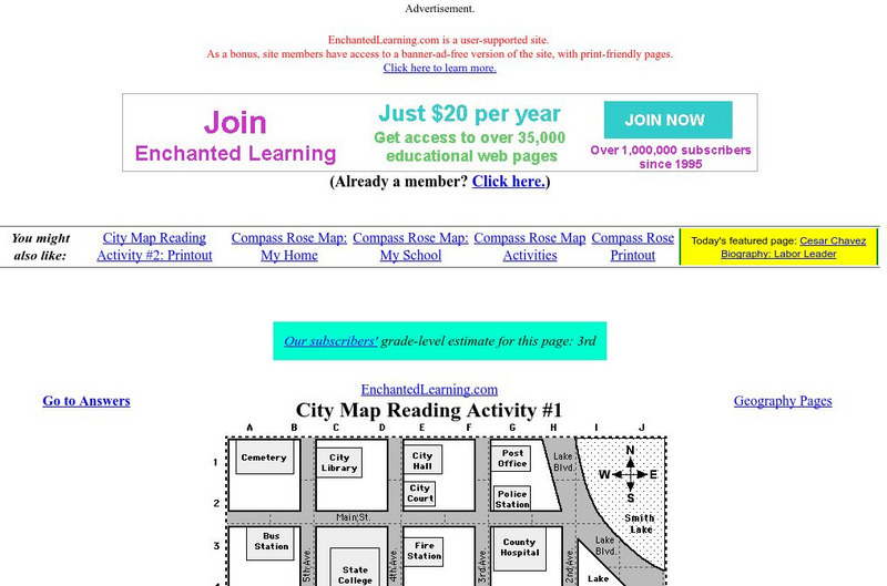
Enchanted Learning: City Map Reading Activity #1
Using a diagram of a labeled map, students follow the directions given to find a certain location.


