Curated OER
Adapting to the Dark-Bats and People
Students consider how cavers make adaptations to the cave as do bats.
Curated OER
The Rain Forest of Costa Rica
Fifth graders examine and discuss the topography, climate, natural resources and artwork of Costa Rica. They develop a diagram of the layers of the rain forest, and design a tourist brochure or advertisement promoting Costa Rica's...
Curated OER
Molecular Biology and Primate Phylogenetics
Pairs of high school biologists compare amino acid differences in the beta hemoglobin of different primates. They use the information collected to construct a phylogenic tree. Follow-up discussion questions are provided. This is a...
Curated OER
"Investigating Soil Color and Texture"
Ninth graders will identify/understand the differences between soil and dirt. They will classify soil color accurately and use Munsell notation to describe it (Munsell books provided).Students will classify soil texture using the feel...
Curated OER
Earthquakes and Seismic Waves
Students explore earthquakes and seismic waves. They investigate how energy is released in the subsurface to create seismic waves. Students explore the inner workings of a seismograph and how they are used to determine the location of an...
Curated OER
Mapping Where Animals Live
What type of reptiles live in New York State? This lesson gets the class thinking about what factors determine where particular animals live. They analyze the Hudson Valley environment, identify specific reptile and amphibian...
Curated OER
Earth Structure and Processes
Students classify different rocks according to their types. In this earth science lesson, students explain how plate tectonics created Earth's landforms. They explain the continental drift theory and sea floor spreading in their own words.
Curated OER
Cookie Topography
Students construct a cross section diagram showing elevation changes on a "cookie island." Using a chocolate chip cookie for an island, they locate the highest point in centimeters on the cookie and create a scale in feet. After tracing...
Curated OER
Denali Park Topographic Maps
Students construct a topographic map of the Denali National Park. They identify different elevations and record historic landmarks in student science journals.
Curated OER
MAPS AND TOPOGRAPHY
Students analyze the details of a topographic map and create one of their own by utilyzing a map of elevations.
Curated OER
Cruising the Mantle
Students explore the plate boundaries of the earth. Through the use of video, internet and hands-on activities, students examine the types of plate boundaries. They create a model to illustrate the movement and interaction of the...
Curated OER
Lord of the Rings - A Study of Tree Rings
Students examine trees and discuss how the environment effected the tree. They also predict what the area look like in fifty years.
Curated OER
GEOGRAPHY: SPACE CENTERS
Students examine the descriptive science dealing with the surface of Earth, its division into continents and countries, climate, natural resources, inhabitants and industries of the various divisions and analyze the political geography...
Curated OER
The 50 States and its Holidays
Though the format of this ELL lesson is confusing (the standards listed are for plate tectonics, yet the objectives are for American geography and holidays), a teacher could glean some ideas from the main idea. Here, pupils complete a...
Curated OER
At The Site Of The Quake
Students research and design an educational earthquake Web site, using the current disaster in Afghanistan as a starting point. They begin by reading and discussing As Many as 2,000 Feared Dead in Afghan Earthquakes which is imbedded in...
Curated OER
Design an Island
Students explore islands. They create a two- or three-dimensional map of an island. They explain how the topography of an area influences the location of water sources, ecosystems, and human settlements. Lesson includes adaptations for...
Curated OER
Stressed to a Fault!
Eighth graders describe how stress builds up in the Earth's crust by the movement of tectonic plates. In groups, they relate the three types of stresses to the types of plate movements and explain how the stress causes faults to form. ...
Curated OER
These Maps are for the Birds
Students identify and study New York State Breeding Bird Atlas maps to learn where different bird species nest and how their distributions have changed over time. They also identify how maps serve as representations of a geographic...
Curated OER
Activity 2: Salinity & Tides
High schoolers explore the effects of tides and salinity on an estuary. In this salinity and tides lesson plan, students complete 3 activities which help them understand estuarine systems. They study the tides in the Chesapeake Bay, they...
Curated OER
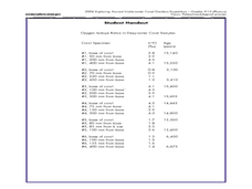
How can deep-water corals be used to determine long-term patterns of climate change?
Students explore the concept of paleoclimatological proxies. In this paleoclimatological proxies lesson, students explain isotope ratios in deep water coral samples. Students write a paragraph about global climate change as it effects...
Curated OER
Interpreting Satellite Images
Students identify differences between photography and satellite imagery space.
Curated OER
The Gifts of the Nile
Get your class thinking about the geography that shaped the Egyptian landscape and culture. They compare ancient climate zones and geogrpahical fetures, locate evidence of plate tectonics, take and quiz, and write a short essay. The...
Curated OER
Vocabulary Words of the Southwest
A simple vocabulary definition worksheet has young geographers of the Southwest putting term meanings into their own words. The fifteen words include (but are not limited to) adobe, butte, canyon, economy, erode, fossil, and landform....


