Hi, what do you want to do?
Curated OER
Climate in Our Back Yard
Learners construct a "A Year in Pennsylvania" poster on which they creatively describe at least three examples of how the climate they live in shapes their lives during every season of the year.
Curated OER
A Model of Earth's Tectonic Plates
Students build a model of the Earth showing tectonic plate boundaries. The pattern for the model is provided in the lesson. This is a very useful hands-on component for a lesson about geology or earthquakes.
Curated OER
Introducing The Gulf Stream
Sixth graders research the average temperatures of different places on Earth. In this earth science lesson, 6th graders explain how the sun's heat cause ocean movement. They discuss how temperature change affects the weather we experience.
Curated OER
Columbus Day Alphabetical Order
In this Columbus Day worksheet, learners read a list of 20 vocabulary words that pertain to the explorations of Christopher Columbus. Students alphabetize the words.
Curated OER
Columbus Day Word Jumble
In this online interactive Columbus Day worksheet, students examine 20 holiday-related words in a word bank. Students use the word bank to unscramble 20 sets of letters to match the terms in the word bank. This worksheet may also be...
Curated OER
Panther Scavenger Hunt
Students research a website to learn about the Florida panther. In this animal research lesson, students use the scavenger hunt directions to search a website about Florida panthers. Students also solve word puzzles within the activity.
Curated OER
Does Humidity Affect Cloud Formation?
Students use NASA's S'COOL database to identify factors that affect cloud formation.
Curated OER
African Cities Are Modern
Students create a mobile that compares the way of life in modern cities in Africa to rural villages in Africa.
Curated OER
America the Beautiful
Students listen to a read-aloud discussing the landmarks of the United States. In pairs, they use the internet to research a landmark of their choice. They create a visual aid to be given with a presentation sharing the information...
Curated OER
Vocabulary Review: Completing Sentences
In this vocabulary worksheet, students check the word that will correctly complete a sentence, 7 sentences. Students choose from 4 words.
Curated OER
"my Dear Little Boys..." Using Wwii Primary Documents: a Letter Home From the War
Students read letters written by soldiers during World War II in order to analyze the soldier's feelings about the war. They explain how these primary sources teach appreciation for the World War II soldier's experiences.
Curated OER
The Flat-Out Truth
In this Earth's shape worksheet, students read an article about a gentleman who believes the Earth is flat. Then students complete 5 short answer questions.
Curated OER
African Safari
Sixth graders gain an appreciation for the different cultures that inhabit the Earth by focusing on the people of Africa
Curated OER
Geography Made Fun with Technology
Young scholars incorporate knowledge box into their classroom activities. For this technology integration lesson, students fill out a graphic organizer using Glossopedia to analyze a new subject.
The Newberry Library
Newberry: Political and Military History: Map 15: The World at War, 1944
Lesson for K-12 using historical map teaches students about the relationship between perspectives of the world and map projections.
National Endowment for the Humanities
Neh: Edsit Ement: Mapping Our Worlds
In this lesson, introduce your learners to the world of maps and discover a world of information online. Students learn how to identify different types of maps, comparing maps to the rooms of a house.
City University of New York
Virtual Geology: Maps Home Page: Topic and Quiz Menus
This collection of resources cover map topics and includes quizzes for improving map and globe usage skills.
City University of New York
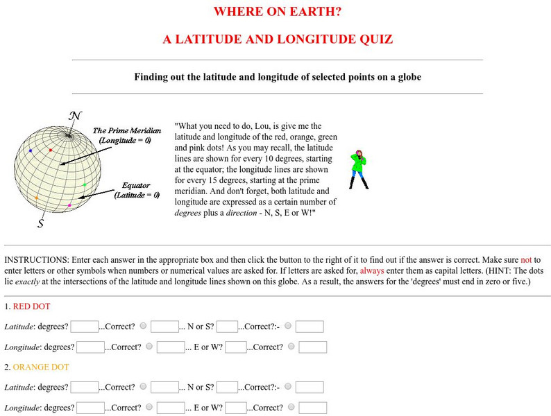
Virtual Geology: Where on Earth: A Latitude and Longitude Quiz
This quiz starts with select points on a globe. Students must determine the latitude, longitude, and direction for each point.
C3 Teachers
C3 Teachers: Inquiries: Maps and Globes
A comprehensive learning module on maps and globes that includes three supporting questions accompanied by formative tasks and source materials, followed by a summative performance task. Students learn what a map and a globe are and the...
BSCS Science Learning
Bscs: Globe at Night Dark Skies
In this inquiry, students predict the best place to stargaze in Arizona based on the brightness of the night sky. Students are introduced to the concept of light pollution and Globe at Night, a global citizen science project in which...
BSCS Science Learning
Bscs: Globe at Night Dark Skies
In this inquiry, students predict the best place to stargaze in Arizona based on the brightness of the night sky. Students are introduced to the concept of light pollution and Globe at Night, a global citizen science project in which...
Other popular searches
- Maps and Globes
- Comparing Maps and Globes
- Reading Maps and Globes
- Communities Maps and Globes
- Examining Maps and Globes
- Using Maps and Globes
- Free Maps and Globes
- Maps and Globes Activity
- Maps and Globes Migration
- Maps, Globes and Atlases
- Maps Skills and Globes
- Globes and Maps Continents


