Curated OER
Reflections on Earth: Exploring Planet Earth from Space
Students examine satellite images of Earth and contrast images at different scales. In this exploring Earth from space lesson plan, students use satellite images to contrast images at different scales, calculate distances from the scale...
Curated OER
Eyes in the Sky
Young scholars examine the use of satellites. In this research lesson, students discuss the history of satellites and how we use the information today. They will conduct interviews with older adults who have lived in the changing times...
Curated OER
The STEREO Mission: Getting The Message Across
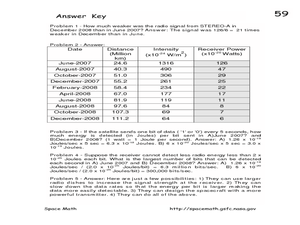
In this STEREO satellites worksheet, students are given a chart with the intensity of the signals from the satellites received on Earth and the distances of the satellite from Earth. Students convert the intensity at each distance to...
Curated OER
Cities and Seasons
Students explore how satellite images show seasonal changes in seven cities in North and South America. Through a sequence of images, they study the green-up and brown-down of the seasons and how seasons change over time. Afterwards,...
Curated OER
How Do Satellites Work?
Students model how satellites transmit data by using numbers not images.
Space Awareness
Valleys Deep and Mountains High
Sometimes the best view is from the farthest distance. Satellite imaging makes it possible to create altitude maps from far above the earth. A three-part activity has your young scientists play the role of the satellite and then use...
Curated OER
A High-Resolution Satellite Photo
In this high resolution satellite photograph instructional activity, students observe a photograph taken by the Lunar Reconnaissance Orbiter of the Tennessee Court House. Students use the photograph to solve 4 problems about the scale of...
Curated OER
Hurricane Shapes: Spatial Patterns on Satellite Images
In this earth science worksheet, students match 21 hurricane satellite images to their appropriate shape. They also answer 4 short answer questions about hurricane shape classification.
Mr. E. Science
Our Solar System
The presentation starts with the scientists who made discoveries about our solar system: Ptolemy, Copernicus, Galileo, Brahe, Kepler, and Newton. It also covers the planets, inner, outer, and Pluto, satellites, and an in-depth discussion...
NASA
Earth's Global Energy Budget
Introduce your earth science enthusiasts to the earth's energy budget. Teach them using an informative set of slides that include illuminating lecturer's notes, relevant vocabulary, embedded animations, colorful satellite maps, and a...
Curated OER
Aruba Cloud Cover Measured by Satellite
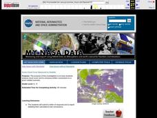
Learners analyze cloud cover and to compose written conclusions to a given related scenario. They submit a letter of response and a report detailing their calculations and conclusions.
Curated OER
Satellite Mobiles
Students discuss satellites and their functions. They design and construct their own satellite out of readily available materials. Students are taught the definition of a satellite. They discuss the two main purposes of satellites:...
Curated OER
Annotating Change in Satellite Images
Young scholars compare a series of satellite images taken 3-4 years apart to investigate the effects of human land use. They annotate the images using ImageJ software and use the annotated images to explain their findings.
Curated OER
Satellite Eyes
Students explore the ways in which satellite images provide details of the Earth's surface and how they are capable of taking digital images of the Earth from space they vary in resolution and breadth. They view how cameras and lenses...
Curated OER
FILLING IN THE GAPS - Acquiring and Analyzing Satellite and Ground-Based Data
Students monitor rainfall, compute daily averages, and compare their methods of computation to those used by actual researchers using satellite observations.
PBS
Passion for Pixels
Picture this: a fun activity for pupils to discover pixels. After learning about digital signals and pixels, scholars act as senders and receivers of an image. The sender indicates zero or one to tell whether each square in a grid is...
American Museum of Natural History
Field Trip Mars
Fly around the Martian surface. Pupils view a presentation on the planet Mars featuring a flyover that shows different views of the surface where rovers have landed and explored on different missions. As individuals watch the images, the...
Curated OER
Can You See What I See?
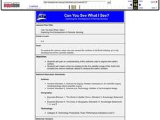
Learners gain an understanding of the methods used to explore the earth's surface. Students create a time line leading to the first satellite image of the Earth that includes the various methods utilized to observe the earth's surface.
Curated OER
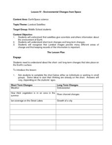
Environmental Changes from Space
Students discuss Landsat Satellites and the use of the images they provide as well as the purpose of keeping records of the information from the satellites. The class works in groups to complete a worksheet on short term and long term...
Curated OER
You Can Die Here – Death Valley California
Students use Google Maps to explore the rain shadow desert. In this climate lesson, students use the Internet, Google Maps, and directed inquiry worksheets to understand how rain shadow deserts form. Students apply climate concepts to...
Curated OER
Storm Clouds-- Fly over a Late Winter Storm onboard a NASA Earth Observing Satellite
Students study cloud data and weather maps to explore cloud activity. In this cloud data lesson plan students locate latitude and longitude coordinates and determine cloud cover percentages.
PBS
Mountains and Rain Shadows
Scholars use an online interactive to learn just how different the other side of the mountain actually appears. They use satellite images, graphics, and videos to compare the impact of winds, oceans, clouds, precipitation, and more on...
NASA
Exploring the Colors of Mars
Minerals on Mars are not that different than those on Earth. Using mineralogy concepts and satellite images, individuals use color to highlight the different surface minerals on Mars when creating a model of the planet. They enhance...
Las Cumbres Observatory
Calculating the Age of Solar System Objects
The number of craters on the surface of solar system objects has a direct correlation to its age. Learners use the concept to determine the age of several objects in the solar system. Using satellite images, they count craters within a...


