NOAA
Investigating Sea Level Using Real Data
The news reports on rising sea level, but how do scientists measure this rise? Scholars use NOAA data including maps, apps, and images to work through five levels of activities related to sea level. Each level in the series adds a new...
International Technology Education Association
Reinventing Time
Take a trip through time. A lesson resource provides instruction on the origin of current measurements for time. The text explains the different tools humans used throughout history to measure time as well as provides examples such as...
Curated OER
The Adventure of Echo the Bat
Students compare different habitats based on satellite imagery. They identify land features in the satellite imagery.
Curated OER
A Look At Sunspots
Students research how the development of new technology has increased our knowledge of how the sun works. This instructional activity is part of a three-part series aimed at showing students how our knowledge of the universe must be...
Curated OER
How Wet Did It Get?
Students measure the rainfall/snowfall on the playground on a rainy/snowy day with a rain/snow gauge. They draw a bar graph representing the amount of water that fell and observe a satellite image of the clouds and local weather system...
Curated OER
Trends of Snow Cover and Temperature in Alaska
Students compare NASA satellite data observations with student surface measurements of snow cover and temperature. They practice data collection, data correlations, and making scientific predictions.
Curated OER
Solar Electricity
In this solar electricity and satellites activity, students calculate the perimeter of a satellite, they find the area of the surface of the satellite and they determine if there is sufficient space for enough solar panels to supply the...
Curated OER
The Plasmasphere
In this plasmasphere worksheet, students read about the dilute region of gases 10,000 kilometers above the Earth where atoms are ionized. Students use a photograph taken by the IMAGE EUV instrument to answer 3 questions about the...
NASA
NASA
Everything you have ever wanted to know about our solar system, space exploration, and more can be found here. Be prepared to clear your schedule; you will be sucked into the app like a star into a black hole.
Curated OER
Measuring Distance and Area in Satellite Images (College Level)
Students are able to download, install, and use Image J image analysis software to quantify change over time in satellite images. They access and download satellite images for specific locations and times. Students set a scale (spatial...
Curated OER
From Pirates to Pilots to Spies
Sixth graders enjoy this introduction to the world of map projections, globes, aerial photographs, and satellite images. This lesson instructs students on the advantages and disadvantages of each earthly representation.
Curated OER
Interpreting Aerial Photographs
Students interpret aerial photographs. They view aerial photographs or satellite-produced images to locate and identify physical and human features. They study satellite images and label their images for bodies of water, clouds,...
Curated OER
Science Excursion: Cover Mapping Land
Students study remotely sensed images and topographic maps to classify land cover types in their watershed area. They take samples in the watershed area to interpret the images.
Curated OER
Earth Images BINGO
Students introduced to different views of the Earth. They play BINGO with boards that are made of images of Earth.
Curated OER
Amelia the Pigeon: What Am I?
Students investigate photos and images both close and far for different types of information.
Curated OER
An application of the Parallax Effect
In this parallax effect worksheet, students observe 2 photographs taken of an active area of the sun by 2 STEREO satellites and 1 photograph taken of the same active area of the sun by the SOHO satellite. Students observe the shift in...
Curated OER
Exploring a City from Space
In this exploring cities from space worksheet, students use a satellite image from the QuickBird Satellite to determine the image scale. They use the image scale to calculate the length of the Bellagio Hotel in Las Vegas, the length of a...
Curated OER
Hinode Studies Loopy Sunspots!
In this sunspots and magnetic fields worksheet, students read about the satellite images taken showing 'loopy' patterns from solar gases and the magnetic fields on the sun. Students solve 2 problems including finding the volume of a...
Curated OER
Keeping Watch on Coral Reefs
Students investigate the dangers Coral Reefs face by investigating satellite images. In this environmental protection instructional activity, students utilize the Internet to discover the types of satellites and sensors used to...
Curated OER
Aurora to Magnetosphere Global Exploration
In this magnetosphere global exploration activity, students read about the instrument on board a satellite launched by NASA called the Radio Plasma Imager. This imager detects echoes from plasma clouds. Students calculate the distance to...
Curated OER
Seeing Solar Storms in STEREO-I
In this geometric calculations of solar storms instructional activity, students use a diagram indicating the location of 2 STEREO satellites, the earth and the sun to calculate the distance between a Coronal Mass Ejection and the Earth....
Curated OER
Kepler-The Hunt for Earth-like Planets
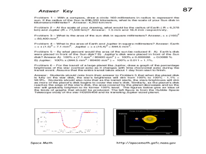
In this hunt for planets activity, students read about the Kepler satellite used to detect exoplanets. Students solve 6 problems including drawing a sun disk and determining the scale in kilometers/millimeter, finding the area of the Sun...
Curated OER
LRO Explores Lunar Surface Cratering
In this lunar surface worksheet, students use an image taken by the LRO satellite to investigate the size of craters on the moon's surface, to determine the crater density and to find the average distance between the craters.
Curated OER
LRO-Searching for Lunar Boulders
In this lunar boulders learning exercise, students use an image taken by the LRO satellite of the surface of the moon to find the scale of the image and determine the number of boulders and their approximate sizes.


