Hi, what do you want to do?
Curated OER
Educational Technology Clearinghouse: Maps Etc: High Roads of Ireland, 1908
A map of Ireland in 1908, showing the "High Roads" with route numbers, the major secondary roads, and major cities.
Curated OER
Educational Technology Clearinghouse: Maps Etc: Ireland: Northern Section, 1910
A map of the northern section of Ireland in 1910, showing county boundaries, cities, towns, ports, railways, canals, rivers, lakes, terrain, and coastal features north of Dublin and Galway.
Curated OER
Educational Technology Clearinghouse: Maps Etc: Ireland: Southern Section, 1910
A map of the southern section of Ireland in 1910, showing county boundaries, cities, towns, ports, railways, canals, rivers, lakes, terrain, and coastal features south of Dublin and Galway.
Curated OER
Etc: Maps Etc: Campaign in Northeast Ireland, 1690
A map of Ulster in the north-east of Ireland during the War of Two Kings (Williamite War or Jacobite War), showing the campaigns in the region, including the siege of Londonderry (Derry), Enniskillen, Battle of Newtown Butler (1689), the...
Curated OER
Etc: Maps Etc: Ireland According to the Act of Settlement , 1653
Map of Ireland, according to the Act of Settlement 26th September, 1653 and subsequent orders. This map is color-coded to show English controlled territory in buff tint, and Irish territory in green. The English garrisons are shown,...
Curated OER
Educational Technology Clearinghouse: Maps Etc: Ireland, 1920
A map showing Ireland as it was in 1920.
Curated OER
Educational Technology Clearinghouse: Maps Etc: Ireland, 1689
A map of Ireland around 1689, showing rivers and major cities.
Curated OER
Educational Technology Clearinghouse: Maps Etc: Ireland, 1920
A map of Ireland in 1920 showing major cities, ports, railroads, canals, steamship routes and historic battlefields.
Curated OER
Educational Technology Clearinghouse: Maps Etc: Ireland, 1660 1800
A map of Ireland from the restoration of Irish monarchy under Charles II in 1660 to its merging to Great Britain in 1800.
Curated OER
Educational Technology Clearinghouse: Maps Etc: Ireland, 1904
"Ireland - From the eighth to the eleventh century was the period she was far more advanced than England in learning and culture.
Curated OER
Educational Technology Clearinghouse: Maps Etc: Ireland, 1914
A map of Ireland in 1914 showing major cities, ports, railroads, canals, rivers, and coastal features. This map has a reference key to the Irish counties, cities, and towns.
Curated OER
Educational Technology Clearinghouse: Maps Etc: Ireland, 1920
A map of Ireland in 1920 showing major cities, ports, railroads, canals, steamship routes and historic battlefields. This map has a reference key to the Irish counties, cities, and towns.
Curated OER
Educational Technology Clearinghouse: Maps Etc: Ireland, 1903
Map of Ireland in 1903, showing major cities, towns, and ports, railways, rivers, and coastal features. This map shows the provinces of Ulster, Connaught, Leinster, and Munster, and is color-coded to show the counties of each province.
Curated OER
Educational Technology Clearinghouse: Maps Etc: Ireland, 1905
Map of Ireland in 1905, showing major cities, towns, and ports, railways, rivers, and coastal features. This map shows the provinces of Ulster, Connaught, Leinster, and Munster, and the Irish Sea, North Channel, St. George's Channel,...
Curated OER
Educational Technology Clearinghouse: Maps Etc: Ireland, 1906
Map of Ireland in 1906, showing major cities, towns, and ports, railways, rivers, and coastal features. This map shows the political divisions of Ulster, Connaught, Leinster, and Munster, and the Irish Sea, North Channel, St. George's...
Curated OER
Educational Technology Clearinghouse: Maps Etc: Ireland, 1641 1892
A map of Ireland from the Irish Rebellion of 1641 to prior to the Irish Government Bill (Second Home Rule Bill) passed by the House of Commons in 1893. The map shows the four provinces of Connacht, Leinster, Munster, and Ulster, the...
Curated OER
Educational Technology Clearinghouse: Maps Etc: Ireland, 1904
A geo-political map of Ireland that shows province and county borders current to 1904, major cities, railroad lines, canals and navigable rivers. Physical features such as mountain ranges with elevation measured in feet, major rivers,...
Curated OER
Educational Technology Clearinghouse: Maps Etc: Great Britain and Ireland, 1789
Map of Great Britain and Ireland in 1789 showing rivers and major cities.
Curated OER
Etc: Maps Etc: England, Scotland, and Ireland, 18th Century
Map of England, Scotland, and Ireland during the 18th Century, showing important cities of the time and major rivers.
Curated OER
Flag of Ireland
The BBC features an overview on the European country of Ireland including key facts, historical background, information on political leaders and the news media, and a timeline of key events. Also provides links to recent news stories and...
Curated OER
Educational Technology Clearinghouse: Clip Art Etc: Archbishop John Ireland
John Ireland (September 11, 1838 - September 25, 1918) was the third bishop and first archbishop of Saint Paul, Minnesota.
Curated OER
Etc: Clip Art Etc: Edward Vi of England and Ireland
Edward VI (12 October 1537 - 6 July 1553) became King of England and Ireland on 28 January 1547 and was crowned on 20 February at the age of nine. The son of Henry VIII and Jane Seymour, Edward was the third monarch of the Tudor dynasty...
Google Cultural Institute
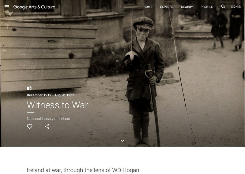
Google Cultural Institute: Witness to War
Photographic collection illustrates key events in the years following the declaration of Irish Independence in 1919.
Other popular searches
- Ireland Geography
- Ireland Potato Famine
- Northern Ireland
- Ireland Geography Rivers
- Ireland Map Coloring Pages
- History of Ireland
- Lesson Plans on Ireland
- Conflicts in Ireland
- Charts Ireland Geography
- Ireland Geography Map
- Ireland Lessons
- Ireland Geography Grade 4


