Curated OER
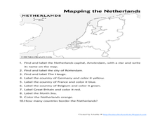
Mapping the Netherlands
In this Netherlands instructional activity, students label cities, countries, landforms, and more. Students label 10 places in the Netherlands.
Cornell University
Too Much of a Good Thing?
Continuing their study of beneficial insects, young entomologists discover where in the world some of these bugs are. By labeling, coloring, and using the scale on a map, pupils explore the territories and arrival of the Asian lady...
California Polytechnic State University
Australian Geography Unit
At the heart of this resource is a beautifully detailed PowerPoint presentation (provided in PDF form) on the overall physical geography of Australia, basic facts about the country, Aboriginal history, and Australia culture and lifestyle.
ProCon
Gay Marriage
The first legal gay marriage in the United States occurred in Massachusetts in 2004. Since then, countless others have tied the knot. Scholars decide whether gay marriage should be legal by reading a history of the issue, analyzing the...
Curated OER
Mapping Brazil
In this Brazil worksheet, students label cities, oceans, and surrounding countries around Brazil. Students label and color 10 places.
Curated OER
South America Map
In this map of South America worksheet, students identify and label the countries in South America. Students improve their understanding of South America.
Curated OER
Mapping Tanzania
For this Tanzania worksheet, students label countries, cities, landmarks, rivers, and more that make up Tanzania. Students label 10 items.
Curated OER
Mapping the United States
In this map of the United States worksheet, students label mountains, surrounding countries, oceans, and more. Students complete 12 tasks.
A to Z Teacher Stuff
Facts About Australia
Here is a quick printable with some basic facts about Australia, such as its population, area, type of government, and currency, as well as a simple drawing of an outline of the country.
Curated OER
The Country of Nigeria - Map Work
In this map worksheet, students label 14 items on a map of Nigeria. They follow directions to label and color Nigeria, and the water-bodies and countries that surround it.
Curated OER
The UK and the Republic of Ireland
In this maps worksheet, students label the cities and countries of the United Kingdom and the Republic of Ireland and answer a short answer questions. Students complete 4 activities.
Curated OER
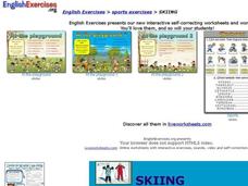
Skiing?
In this skiing worksheet, students watch a skiing video and then label pictures about skiing. Students label 6 pictures total on this worksheet.
Curated OER
The Renaissance, Background
Students are introduced to the Renaissance by viewing a PowerPoint presentation. In this Renaissance activity, students locate the important countries and cities of the Renaissance. Students compare how it was in England from the rest of...
Curated OER
Email - reading comprehension
In this reading comprehension learning exercise, students label pictures, fill in the blanks to sentences, answer yes or no questions, and more having to do with email. Students complete 8 activities.
Curated OER
The Role Of NATO
Students examine the role of the North Atlantic Treaty Organization (NATO). In this NATO lesson plan, students research the Truman Doctrine, the Marshall Plan, Winston Churchill's "Iron Curtain" speech, and the Berlin airlift and how...
Curated OER
Labeling the World
Sixth graders conduct research on the countries found on the labels on their clothing. They locate the countries on a map, research the labor practices on countries that export clothing to the U.S., and create a graph using the information.
Curated OER
Spanish-Speaking Countries
Learners explore geographic areas. They list as many countries as possible, divide the countries into groups, and label the groups with logical names. As an introduction into Spanish, students memorize all the Spanish-speaking...
Curated OER
Labeling a Map of Australia
Third graders label a map of Australia. Using the internet, they research the history and maps of the continent and print a blank map. They review on how to use a compass rose and legend. In groups, they create a brochure to share...
Curated OER
World Map Labels
In this geography skills worksheet, students identify the countries and bodies of water labelled on the maps of the world, Africa, Asia, Canada, Europe, the Caribbean, the Middle East, North America, Australia, and South America.
Curated OER
Country: Korea
Students inspect Korea's geography, climate, history, and culture. They practice writing Korean numbers and review information about the Korean War and the division of the country into north and south. They label and color a map of South...
Curated OER
Country: Japan
Young scholars observe live Webcam views of Japan. They study its economy, government, and culture through paintings and facts. They label a map of Japan with its cities and rivers.
Curated OER
Labeling a Map of the British Isles and Elapsed Time
In this map work and elapsed time activity, students label England, Scotland, Wales, and Ireland on a map. They calculate the elapsed time of a delivery that is described in a word problem that is broken down into four parts.
Curated OER
European Cities
Students study European cities and label countries on a map, match cities to countries, and answer true and false questions. In this European cities lesson plan, students also guess the names of cities they see pictures of.
Curated OER
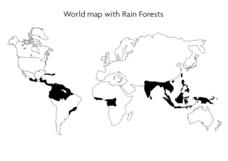
World Map With Rain Forests
In this geography worksheet, students study a map of the world which shows shaded areas indicating where the rain forests are located. There are no labels for countries or continents.
