Curated OER
Derivative Analysis
High schoolers analyze the derivative of a graph. In this calculus instructional activity, students identify the different behavior of a graph. They label concavity of the graphs as increasing or decreasing.
Curated OER
Alternate Interior Angles
Label angles of parallel lines to analyze the angles created by a transversal and two parallel lines. They graph their lines and observe the similarity and difference in the angles.
Curated OER
Exploring Vertical Asymptotes
Scholars identify the domain of a rational function in this precalculus lesson. They identify the removable discontinuity and label what will make the denominator zero. Learners also describe properties of the graph as it relates to the...
Curated OER
Geography Booklet
Sixth graders explore geography terms. Students use resources to find real examples of landforms in the world. They create a map showing the landform. students label the surrounding features, countries and states. Students use each...
Curated OER
Students as Consumers: The Relationships Between Communities
Students survey the clothing they are wearing to determine where it was made. They work in groups to locate the countries where the clothing was manufactured, develop questions about what makes a good purchase and work with a buddy class...
Curated OER
How Are Boundaries Made, Kept, Broken?
Students perform raps and analyze issues among the rich and poor. They explore how countries are labeled as "third world" and "first world." They create a dialectical journal and examine the country of Nigeria through the reading of...
ProCon
Daylight Savings Time
An entomologist named Geroge Vernon Hudson is credited with proposing Daylight Saving Time (DST) so he could better study his insects. Using the informative website, scholars read a brief introduction to the topic and then explore the...
American Museum of Natural History
Global Grocery
A walk through the grocery store is like a walk around the world. An interactive activity shows popular grocery items and where the ingredients originate. Perfect as a remote learning resource, the lesson connects groceries to the...
Weebly
Ancient China
From China's physical geography and earliest beginnings of civilization to the Qin and Han dynasties, here is a nicely designed worksheet on ancient China, which includes a graphic organizer and timeline to summarize the reading...
Curated OER
Map of Argentina
In this map of Argentina activity, students label key areas, cities, bodies of water and surrounding countries, then color the map according to directions.
Curated OER
Exploring the Map of Morocco
In this exploring the map of Morocco activity, students find and label cities, islands, bodies of water, mountains, deserts and other countries around Morocco.
Curated OER
Shopping for Souvenirs In the Middle East
Students participate in a role play in which they are shopping for souvenirs in the Middle East. Using maps, they locate the Middle East and identify each country within the region. They create a key map for the types of souvenirs that...
Curated OER
Mexico and Central America Map
In this outline map worksheet, learners study the political boundaries of Mexico and the Central American countries. This map is labeled with the country names.
Curated OER
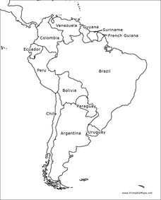
South America Outline Map
In this blank outline map learning exercise, learners explore the political boundaries of South America and the nations there. This map may be used in a variety of classroom activities. The map is labeled with the country names.
Curated OER
Mexico and Central America Map
In this blank outline map activity, students study the political boundaries of Mexico and Central America. Each of the counties is labeled and the capital cities are starred.
Curated OER
Europe Outline Map (Labled)
In this blank outline map worksheet, students study the political boundaries of the labeled European nations.
Curated OER
Asia Outline Map
In this Asia outline map worksheet, students explore the continent as they label the 47 countries. The countries are numbered and lines for the answers are provided on the sheet.
Curated OER
Australia/Oceania Outline Map
In this Australia and Oceania outline map instructional activity, students explore the region of the world as they label the 14 countries. The countries are numbered and lines for the answers are provided on the sheet.
Curated OER
Winter Celebrations
Students draw and label pictures about holiday customs and traditions from their countries.
Curated OER
Population-Building a Foundation
Students research to find information about populations and complete world maps by labeling the current population, and determining the 10 countries with the largest population. They search the "World Population Data Sheet." On the third...
Curated OER
Tourism in Northern Ireland
In this tourism worksheet, students label pictures of tourist destinations with the name of the country they are located in, write sentences about pictures showing damage caused by tourists, identify locations on a map, and fill in...
Curated OER
Map of Italy
In this map of Italy worksheet, learners find, color and label cities, surrounding countries, bodies of water and landforms in the country of Italy.
Curated OER
Creating a Map of France
In this crating a map of France activity, students find and label important parts of France, bodies of water, mountains and surrounding countries.
Curated OER
Map of Egypt
In this map of Egypt worksheet, students label the cities, bodies of water, surrounding countries and color the map according to the directions.


