Curated OER
Hawaii State Map
In this Hawaii state map learning exercise, students color and label important locations and physical features on the map of the 8 islands of Hawaii.
Curated OER
Massachusetts State Map
In this Massachusetts worksheet, students will study a map of the state. Students will use this map to label and/or familiarize themselves with various aspects of the state.
Curated OER
South Carolina State Map
In this map of South Carolina worksheet, students color and label major cities and physical features in South Carolina. There is also a map showing the location of the state in the U.S.
Curated OER
Tennessee State Map
In this Tennessee state geography learning exercise, students color and label major cities and physical features on the map. Students also study a second map of the U.S. that shows the location of the state of Tennessee.
Curated OER
Virginia State Map
In this geography of Virginia worksheet, students color the map and label major cities and physical features. Students also study a second map showing the location of the state of Virginia in the United States.
Curated OER
Delaware State Map
In this geography of Delaware activity, students color the map and label major cities and physical features. Students also study a second map showing the location of the state of Delaware in the United States.
Curated OER
California State Map
In this geography of California instructional activity, students color the map and label major cities and physical features. Students also study a second map showing the location of the state of California in the United States.
Curated OER
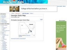
Georgia State Map
In this geography of Georgia learning exercise, students color the map and label major cities and physical features. Students also study a second map showing the location of the state of Georgia in the United States.
Curated OER
Florida State Map
In this geography of Florida worksheet, students color the map and label major cities and physical features. Students also study a second map showing the location of the state of Florida in the United States.
Curated OER
Oklahoma State Map
In this history instructional activity, students view and label on a state map of Oklahoma its regions, major cities, important landmarks, compass rose and legend.
Curated OER
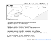
The Country of Kenya
In this map completion worksheet, learners observe a map and map scale of Kenya to find and label bodies of water, cities, countries, and the equator. Students answer 11 questions.
World Maps Online
Introduction to the World Map
Students identify the differences between maps and globes. In this map skills instructional activity, students are shown a globe and a map and recognize the differences. Students use post-it notes to locate several locations on the world...
Curated OER
"Yarning" About Latitude and Longitude
Students identify various locations using latitude and longitude. In this map skills lesson, students use yarn and labels to create a "human globe." Students identify the Prime Meridian, the Equator, and Northern and Southern Hemisphere.
Curated OER
What a Relief Map
Students create a map using cookie dough. In this geography lesson, students research the physical features of a country, draw a diagram and design and create a map out of cookie dough.
Curated OER
Getting to Know France
In this map skills worksheet, students answer 14 questions about the geography of France. Students then draw a rough map of France. It is assumed that access to an atlas is available.
Curated OER
North American Biomes
In this Science worksheet, students color a biome map of North America. Students color the map by solving the clues listed on a separate sheet of paper.
Curated OER
Where Is Rome?
Third graders discover Ancient Rome through maps and worksheets. In this world history activity, 3rd graders locate Rome on a world map and identify the scope of the Roman Empire. Students label an entire map of Italy after...
Curated OER
Kool Kumara Lesson Plans - Healthy Living
Students read graphs as they work with recommended daily intakes of nutrients. In this math and nutrition lesson, students examine Recommended Daily Intake Maps to establish how much of the daily requirement is met by eating on kumara....
Curated OER
Ecology of the Savanna-Forest Boundaries in Central Brazil
Students explore photosynthesis. In this photosynthesis lesson, students label parts of photosynthesis and take notes. Students conduct experiments on leaves, make observations and record their findings.
Curated OER
All About the Animals
Whose footprints are those? After reading Janet Halfmann's book, Little Skink's Tail, young scholars use footprints to determine where on a gridded map certain animals have been spotted. They use the map to answer 3 questions, one...
Curated OER
ESOL School Map Identification
Students review a school map and identify areas along with vocabulary words. They label a map as a class then create corresponding flash cards and practice new vocabulary flash cards in pairs.
Curated OER
Rhode Island State Map
In this geography of Rhode Island worksheet, students color and label a map with the major cities and physical features. Students also study a U.S. map to learn the location of the state of Rhode Island.
Curated OER
Blank Map: The United States of America
In this map worksheet, students use the blank outline map of the United States to label the 50 states or for any other study purpose. Each state boundary is shown with no name labels.
Curated OER
Australian Map (Regions)
In this Australian map worksheet, students research and label the regions of Australia on an Australian map. Students check their labeled regions when completed.
Other popular searches
- Map Labeling
- Africa Map Labeling
- Midwest Map Labeling
- Geography Map Labeling
- Labeling a Map Continents
- Blank Labeling Maps
- Labeling Maps Pangaea
- Labeling Map Parts


