Hi, what do you want to do?
Curated OER
Affects of Geography on Colonial Cultures
Sixth graders examine the effects of geography on the development of culture. They discuss how geography can affect the lifestyles and development of a society's culture. Students examine the geography and climate of New England and the...
Curated OER
John Muir - Around the World in 76 Years
Sixth graders create timelines of John Muir's life while playing a game based on John Muir's travels. They discover that John Muir traveled around the world to compare and contrast natural phenomena and to speak out about preserving...
Curated OER
A Nation Divided
Students compare the physical and human characteristics east and west of the 100th meridian to answer twelve questions. They write a summary of their findings.
Curated OER
IDP Introduction
Fourth graders examine the three regions of North Carolina through class discussion of favorite places in the state and a review game based on the game of twister. The different colors on the twister sheet represent the different...
Curated OER
Lewis and Clark
Ninth graders study the plants and animals Lewis and Clark discovered on their expedition. There is a plant illustrator, a plant recorder, an animal illustrator, and an animal recorder. They research the plants and animals and the ...
Curated OER
Welcome to McMenyea's Africa Menu
The layered curriculum includes this activity: Students research one of the following African leaders: Idi Amin, Nelson Mandela, or Momar Khadafi. Write ten interview questions for them and then answer the questions as you think they...
Curated OER
Mongolia Geography
Students examine the geography and culture of Mongolia. Individually, they cut out cut-outs of animals to place on their maps and label the grasslands and desert areas. They locate major cities and rivers along with vegetation.
Curated OER
Windsor Opposes Waste - WOW!
Students participate in paper recycling. They are taught to environmental awareness of recycling and its importance in their future. Students discuss and identify the problems of how they can minimize waste. They brainstorm suggestions...
Curated OER
Exploring the Internet for Information
Learners identify and use the internet as a resource for information. They integrate the writing process and create a multimedia project using the information from an internet research. Projects can be created from Microsoft Word,...
Curated OER
Castles and Forts of Wales and Oregon
Students compare a castle in Wales to a fort in Oregon and design and build a castle or fort. In this structure study lesson, students complete activities to study castles in Wales to forts in England. Students then design their own fort...
Curated OER
Name That Place: Cultural Place Names in the United States
Students examine the origin of the people that settled in the United States. In this United States History lesson, students work in small groups to complete several activities that explore early settlement, such as a worksheet, a...
Curated OER
Deforestation
Students identify the different tropical rainforests in the world using a map. In this ecology lesson, students describe the different methods of deforestation. They create a memo and present it to class.
Curated OER
Tic-Tac-Toe for Layers of the Earth
Eighth graders identify the different layers of the earth. For this earth science lesson, 8th graders choose a project to do from a given list according to their learning style. They present their finished project in class.
PBS
Pbs Learning Media: Mapping Landforms and Water Bodies: Lesson Plan
Learn about different landforms and water bodies and the various characteristics that make them distinct from one another in this lesson plan from WGBH. Navigate around a virtual island to unlock information -- including videos and...
Scholastic
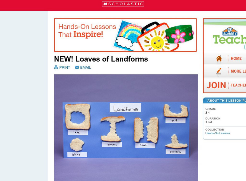
Scholastic: Loaves of Landforms!
A foundation in geography begins with an understanding of the terms geographers use to describe the features of Earth. This lesson plan is designed to help young scholars grow their vocabulary and learn to recognize common landforms in a...
Math Science Nucleus
Discovering How Landforms Are Created on Earth
Learners compare water and ice erosion to discover how landforms are created.
Common Sense Media
Common Sense Media: Wondering About Landforms in Asia
Following a guided observation through Google Earth of a landform in Asia, students will be able to form questions that reflect what they have observed and what they want to know about that landform.
Alabama Learning Exchange
Alex: Landforms Acrostic Poetry
Students will write acrostic poems using scientific information about various landforms. These poems will reinforce concepts learned in science.
Math Science Nucleus
Math/science Nucleus: Observing Different Landforms
Lesson plan with subsequent pages to use with the lesson. Images with landform word match up and additional work on earth modeling.
Math Science Nucleus
Math Science Nucleus: Maps as Tools
A series of lessons in which students learn about landforms. Includes interpreting landforms, creating landforms, and information on Angel Island.
Scholastic
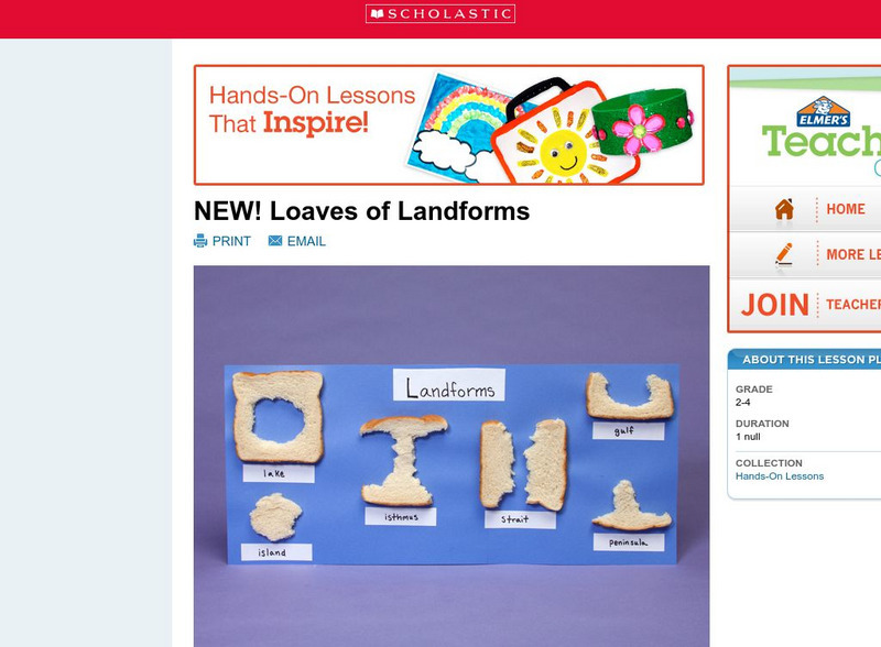
Scholastic: Loaves of Landforms
This is a comprehensive lesson plan to teach primary students about landforms. A foundation in geography begins with an understanding of the terms geographers use to describe the features of Earth. Help students grow their vocabulary and...
Science Education Resource Center at Carleton College
Serc: State Map Poster
This is a project where students pick a state, study its landforms and data about its geology, and produce a poster that outlines how the state's geography evolved over time. An example of such a poster is provided on a downloadable...
Better Lesson
Better Lesson: What Shapes the Land?
In this lesson, the teacher will read a book about different landforms. The children will learn about the features of the landforms and how they were shaped by natural forces. Then text features will be discussed. The children will then...
Discovery Education
Discovery Education: Unique Landforms
The title of this lesson is somewhat misleading and may be a mismatch, as well as the grade levels noted. It is really about transportation. Students conduct extensive research, both online and by phone, and compare various methods of...
Other popular searches
- Landforms and Water Forms
- Canada Geography (Landforms)
- Earths Landforms
- Landforms Lesson Plans
- Landforms of Colombia
- Ocean Floor Landforms
- Definitions of Landforms
- Different Landforms
- Canada Geography Landforms
- Google Earth Landforms
- Geographic Landforms
- Landforms on Neptune


