K5 Learning
Landforms
Valleys, mountains, and plateaus are just a few geographic landforms on our Earth. Read about these types and more in a brief landform passage. After reading, learners respond to six short answer comprehension questions.
Curated OER
Landforms of Illinois
Fifth and sixth graders are introduced to the primary landforms of Illinois and discover how they were created. Landform cards are made for each pupil. They use the twenty-questions format until they have identified each one. Then,...
Curated OER
Wet Water, Dry Land
Young scholars observe and examine relationship between landforms and bodies of water, recognizing differences between them. Students then define island, peninsula, isthmus, archipelago, lake, bay, straight, system of lakes, and identify...
Curated OER
Water Creates a Cave
Students study the role of water in limestone cave formation and create a cave on karst-like grid on paper.
Curated OER
Landforms - Landform Types (Matching)
In this landforms instructional activity, students match land forms with their definitions. Students complete 11 matches total on this instructional activity.
Curated OER
Landforms - Landform Examples in the Philippines (Matching)
In this landforms worksheet, students match the landforms to their definitions. Students complete 10 matches on this worksheet and answer true and false and multiple choice questions about landforms in the Philippines.
Curated OER
Google Earth Geology Field Trip
Students take a virtual field trip around California using Google Earth. In this geology field trip lesson, students explore landforms and a variety of rocks located in California. Students compare environments where rocks are...
Curated OER
Landforms of Illinois
Young scholars discover the primary landforms of Illinois. They examine how those landforms were formed as well. In groups, they research one of the landforms from their vocabulary list. They create their landform in a shoebox and...
Curated OER
Landforms
Students begin their examination of landforms. Using a map, they locate and identify the major landforms on Earth. They discuss how landforms affect the lifestyle of the community and determine which goods and services the community...
Curated OER
Landforms By Hand: Geography, Map Skills
Students experiment with landform vocabulary by using their own hands and a bar of soap as media.
Curated OER
I Love the Mountains
First graders discuss and define different landforms. They read the book "Our Land", sing a landform song and perform it with motions and then complete a worksheet.
Curated OER
Layer By Layer
Have your class learn about the formation of the Grand Canyon using this lesson. After listening to a variety of stories about the Grand Canyon and erosion, learners complete worksheets related to the geology of this area. What a...
Curated OER
The Geography - Writing Connection
Young scholars examine and describe the four physical systems of the Earth. Using two of the systems, they practice their writing skills and use vocabulary associated with the different types of landforms. They predict the types of...
Curated OER
Geography Challenge
In this geographical features worksheet, students read the 10 statements about geographical features. Students select the correct to complete 10 statements.
Curated OER
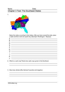
Chapter 3 Test: The Southeast States
In this geography worksheet, students complete a test about the southeastern United States. They name the states, tell about the climate and crops, complete a matching activity about the landforms. and another about the industry.
Curated OER
Island formation
Young scholars explain what an island is, and distinguish islands from similar landforms. They compare and contrast the different ways in which islands are formed.
Curated OER
"Now and Then" Comparing Present Day with Medieval Times
Eighth graders compare a present-day social issue with a medieval issue. They use technology tools to conduct their research and demonstrate their new knowledge. Students present their findings to the class in the form of a PowerPoint.
Curated OER
Edible Maps
First graders, in groups, identify major geographical features of Texas. They form a topographical map of Texas using edible dough, candy, etc. They present and then eat their maps.
Curated OER
Metropolitan Areas in the USA
Fifth graders explore why people live in certain regions of the United States. They investigate information on specific metropolitan areas such as temperature, population, natural resources, precipitation and landforms. In groups, 5th...
Indian Land Tenure Foundation
Relationships to Places
Young historians take a look at how the Indian tribes of California promoted a mindful relationship between people and the land. They begin to understand how the Indians were champions of conservation, and at preserving the natural...
Curated OER
Chinese Landscapes
Learners explain some of the topographical features of China's landscape. They view a Chinese landscape and discuss their view of the harmony between man and nature, then create their own karst mountain scene.
Curated OER
Archaeological Soils
Students evaluate how archaeologists use soils to interpret sites and determine components of a soil sample.
Curated OER
Landform Dictionary
Third graders use a word processing program to create a working dictionary, including definitions and pictures, of physical land forms used in the study of different regions of the world.


