Scholastic
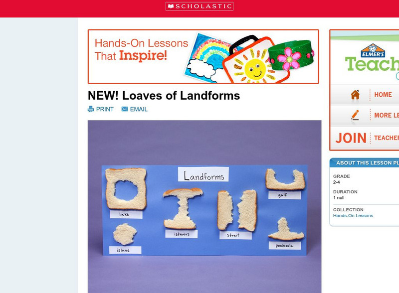
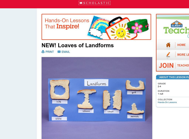
Scholastic: Loaves of Landforms!
A foundation in geography begins with an understanding of the terms geographers use to describe the features of Earth. This lesson is designed to help students grow their vocabulary and learn to recognize common landforms in a hands-on...
Math Science Nucleus
Math Science Nucleus: Maps as Tools
A series of lessons in which students learn about landforms. Includes interpreting landforms, creating landforms, and information on Angel Island.
Scholastic
Scholastic: Loaves of Landforms
This is a comprehensive lesson plan to teach primary students about landforms. A foundation in geography begins with an understanding of the terms geographers use to describe the features of Earth. Help students grow their vocabulary and...
Science Education Resource Center at Carleton College
Serc: State Map Poster
This is a project where students pick a state, study its landforms and data about its geology, and produce a poster that outlines how the state's geography evolved over time. An example of such a poster is provided on a downloadable...
Science Education Resource Center at Carleton College
Serc: Mn Step: Student Created Landform Maps With Glacial Emphasis
An activity where students work together to make topographic maps of a local park. The map must include a key and the grid locations of landforms in the park.
National Association of Geoscience Teachers
Quaternary Glacio Fluvial History of the Upper Midwest Using Anaglyph Stereo Maps
Students examine the anaglyph stereo map and use textures to generate a surficial geology map of the Upper Midwest. They can then interpret the textures in terms of landforms, geomorphic features, and earth-surface processes, as well as...
Science Education Resource Center at Carleton College
Serc: Geologic Photo Field Trips for Introductory Physical Geology
Students participate in a series of virtual geology field trips by observing and describing rock outcrops, geologic structures, and landforms in field based photographs.
Alabama Learning Exchange
Alex: Forces That Change the Land
Students will use websites and other resources to find information about the following landforms: mountains, canyons, and valleys.
Crayola
Crayola: Airplane View
Show off your knowledge of geography. Draw your state, its neighbors and indicate notable landforms as if you were viewing them from the window of an airplane.
Science Education Resource Center at Carleton College
Serc: Mn Step: Rock Identification and Usage
In this activity, young scholars explore rocks using their five senses. They sort them into groups, learn about landforms, and learn how rocks are used by humans. Their discoveries are recorded in their science notebooks.
Science Education Resource Center at Carleton College
Serc: Investigating the Geologic History of Southeast Minnesota
This activity is an inquiry-based, earth science field investigation of the geology of southeast Minnesota. Students will make observations of rock outcrops and landforms in the region using maps, pictures, and field sampling, then use...
Utah Education Network
Uen: Landforms in a Tub
For this activity, students create models in a tub or sandbox that simulate erosion caused by weathering.
Science Education Resource Center at Carleton College
Serc: Mapping the Glaciers
In this activity, students will use Minnesota Geological Survey 3-D maps of the upper Midwest to trace the outlines of where they believe glaciers may have affected North America. They will identify landforms that resulted from glacial...
Science Education Resource Center at Carleton College
Serc: Sandbox Modeling
Students create landforms using layers of colored sand, then construct a topographic map and a cross-section. This is an investigation that was presented to pre-service science teachers. The format would be similar with students, with...
TeachEngineering
Teach Engineering: How Dense Are You?
Students learn about geotechnical engineers and their use of physical properties, such as soil density, to determine the ability of various soils to offer support to foundations. In an associated activity, students determine the bulk...
Crayola
Crayola: Birth of Islands (Lesson Plan)
This site is a lesson plan that incorporates language arts, social studies, science, and art. After studying islands, and how they're formed, students create their own models using clay. Also provides resources and adaptations. (To...
Science Education Resource Center at Carleton College
Serc: The Science of Puddles
Students will look at their schoolyard and determine where a puddle will form after a heavy rain. They will map the school yard and draw chalk lines to demonstrate their predictions. After a rain children will check their predictions and...
Science Education Resource Center at Carleton College
Serc: Global Land Vegetation
This Global Land Vegetation module is one of four Studying Earth's Environment from Space modules. It consists of three sections: class resources, computer lab resources, and a glossary and acronym List.
Science Education Resource Center at Carleton College
Serc: Geo Blocks 3 D Interactive 3 D Geologic Blocks
This interactive tutorial on visualizing geologic features contains animated block diagrams that show how the surface expressions of dipping layers, folds, igneous intrusions, and faults are related to subsurface structure and cross...
National Association of Geoscience Teachers
Serc: Mapping Potato Island
In this hands-on activity, students make a topographic map to describe the shape of a potato. They will gain an understanding of how contour lines are used to describe the shape of the land surface.
Other popular searches
- Landforms and Water Forms
- Canada Geography (Landforms)
- Earths Landforms
- Landforms Lesson Plans
- Landforms of Colombia
- Ocean Floor Landforms
- Definitions of Landforms
- Different Landforms
- Canada Geography Landforms
- Google Earth Landforms
- Geographic Landforms
- Landforms on Neptune
