Curated OER
Landscape Picture Map - Lesson 8 (K-3)
Students explore the functions of landscape picture maps. In this geography skills lesson, students examine a landscape picture map and identify buildings on the map where people are employed. Students also participate in a discussion...
Curated OER
Mapping the Civil War
Students identify the locations of pivotal American Civil War battles. In this map skills lesson plan, students label Fort Sumter, Antietam, Vicksburg, Gettysburg, and the Battle for Atlanta on an outline map. The map is not included.
Curated OER
Mapping Personal Narratives
Second graders write a personal narrative using webs they created and a story map worksheet. In this personal narrative lesson plan, 2nd graders make lists of ideas to write about and pick one to focus on.
Curated OER
Story Mapping
Students prewrite a story using graphic organizers. In this prewriting lesson plan, students create a story map before they start their writing.
Curated OER
Map Literacy
Students locate their home state on a map. They differentiate between physical and population sizes of states. In two groups, students "become" states with string for boundaries. They ascertain that area does not always equal large...
Curated OER
Using Maps to Learn About Antarctic Topography
Young scholars explore maps and familiarize themselves with features of Antarctica. They utilize a topographical map to create a three-dimensional model of Antarctica. They identify and describe the different regions of Antarctic ice.
Curated OER
United States Map- Continent, Country, State
Students identify their continent, country, and state on a globe. In this geography lesson, students use a globe to identify the seven continents, the United States, and the state which they live in. Students define key terms.
Curated OER
Sub-Saharan Maps
In this geography skills activity, students draw real or imaginary maps that feature escarpment, rift valleys, gorges, diamond mines, plateaus, mountains, lakes, rivers, and gold mines.
Curated OER
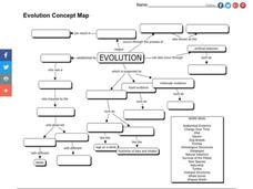
Evolution Concept Map
In this evolution concept map worksheet, 7th graders use the vocabulary terms related to evolution to complete the evolution concept map.
Curated OER
Map Skills
Students examine the nations, battlefields, troop movement of the Germans through Belgium and the location of both fronts during World War I by creating a map. They visualize the strength of the Germans early in the war.
Curated OER
Freshman Science Project-Part 1A-Science Concept Map
In this science project worksheet, students draw a concept map of their science project and use a rubric to determine their progress on their concept map.
Curated OER
Bubble Map
This PowerPoint provides a brightly colored "bubble map" featuring one large center circle and a smaller colored circle in each corner. This is an attractive generic graphic organizer that could be used in any content area.
Curated OER
Treasure Map
In this writing worksheet, students find a treasure by following the correct path on the map. Students write directions telling exactly how to get there. A list of sequential words is provided to help students write directions.
Curated OER
Natural Resources and Land Use
Seventh graders explore natural resources and land use. In this geography skills lesson plan, 7th graders view a PowerPoint presentation on the topics and discuss the distribution of natural resources and land use issues in East Asia....
Curated OER
Map of Town
Third graders draw a map of the town given different sites to locate on the map by the teacher. They explain that latitude and longitude are used to locate places on maps and globes, identify the distinctive physical and cultural...
Curated OER
Wind Mapping With Bubbles
Students identify wind direction by using bubbles. In this weather lesson, students use a small container of bubbles and a map of their house to create a wind map. Students blow bubbles and note the general direction the bubbles are...
Curated OER
Topographic Mapping
Students create a three dimensional model of a two dimensional topographic map. They explore how the two dimensional significance of a topographical map is helpful to create a three dimensional model. Students use other topograhical...
Curated OER
Story Elements Map
In this excellent story elements map worksheet, students view and discuss the advantages and disadvantages of using a graphic organizer to help structure stories and compositions. To my eye, this graphic organizer will help students...
Curated OER
Writing/Setting/The Adventures of Tom Sawyer--Map Your Childhood Project
Students write using a strong sense of place. In this Adventures of Tom Sawyer lesson, students discuss the importance of setting to the novel. Students brainstorm five specific locations that contribute to their personal history....
Curated OER
Earth at Night
Students examine the Earth at night. In this geography lesson, students identify the continents at night using various Internet Web sites. This lesson may be adapted for use with middle school and high school students.
Curated OER
Countries of the World
Learners define the meaning of the word country. In this countries of the world map lesson plan, students identify boundaries, countries, and symbols within countries on the map. Learners distinguish the words country and continent.
Curated OER
Around the Town
In the world of GPS, make sure your kids can still read maps and determine distances between locations. You will need neighborhood street maps, ideally of your class' home turf. Ask kids questions about different locations in relation to...
Curated OER
Geography of South America
Student's identify geographic features of a South American map. They use the scale of the map to calculate distances between points. They identify examples of the five geographic themes on the map of South America.
Curated OER
Finding Captain Hook's Treasure
Students use their map-reading skills to find Captain Hook's treasure. They see how the directions on a map correspond with "real-life" directions, and that symbols on a map represent real things.


