International Technology Education Association
Reinventing Time
Take a trip through time. A lesson resource provides instruction on the origin of current measurements for time. The text explains the different tools humans used throughout history to measure time as well as provides examples such as...
University of California
The End of the Cold War (1979-1991)
Scholars use primary and secondary documents, as well as video evidence, to investigate the end of the Cold War. After completing the final installment of an eight-part series, class members better understand the issues surrounding...
College Board
2015 AP® Human Geography Free-Response Questions
How are population and political power related? What is the significance of the globalization of English? Why do refugees leave their home countries? Using structured short-answer questions, scholars unravel complicated dynamics with...
Teaching Tolerance
Identity Portraits
When you look at me, what do you see? Young learners answer this question by creating a portrait that reflects the identity of one of their peers. First, class members create interview questions. Then, they interview classmates to...
Curated OER
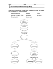
Cellular Respiration Concept Map
For this respiration worksheet students complete a concept map using the vocabulary words that are used in the respiration cycle.
Curated OER
Topographic Maps
Students complete a worksheet about topographic mapping. In this map skills lesson, students examine the features and discuss the uses for topographic maps.
Curated OER
Class Amphibia Concept Map
In this class amphibia worksheet, students complete the concept map using words or phrases provided. They fill in 11 blanks with the correct answers.
Curated OER
BOLTSS Map
In this geography worksheet, students identify the six features always used on maps. They identify each of these features by the acronym BOLTSS. Students examine the Melbourne Cricket Ground shown and respond to the 4 questions that follow.
Curated OER
Europe Outline Map
In this outline map worksheet, students examine the political boundaries of the continent of Europe. The map may be used in variety of activities that individual teachers create to accompany it.
Curated OER
North America Outline Map
For this blank outline map worksheet, students investigate the political boundaries of the continent. This map may be used for a variety of classroom activities.
Curated OER
North America Outline Map
In this blank North America outline map worksheet, students study the political boundaries of the continent. This outline map may be used for a variety of geographic activities.
Curated OER
Using Local Geography to Make Maps
Students research, create, and present a scale representation of the county in which they live.
Curated OER
Mapping the Transcontinental Journey
Young scholars develop their geography skills. In this Lewis and Clark instructional activity, students collaborate to calculate the time and distance of different segments of the expedition. Young scholars compare their estimate to...
Curated OER
Terrabagga Activity using a Magnetometer
Students use a magnetometer to determine the orientation of a magnetic field. For this magnetism lesson, students build a simulated planet and use a simple magnetometer to determine the orientation of their planet's magnetic field.
Curated OER
WORLD GEOGRAPHY
Students identify and analyze map symbols and map grids by completing various worksheets and creating their own map using these skills. Students identify and analyze what latitude and longitude are on a map to play a game of Bingo....
Curated OER
Mollusks and Annelids Concept Map
In this mollusks and annelids concept map worksheet, students complete a concept map on the characteristics of invertebrates. They fill in 13 blanks using the correct word from the list.
Curated OER
Introduction to Animals Concept Map
In this animal science activity, students complete a concept map on the features of animals. They fill in 12 blanks with the correct words from the list.
Curated OER
Fishes Concept Map
In this marine science worksheet, students complete a concept map on the different types of fish. They fill in 8 blanks with the correct answer from the word list.
Curated OER
Birds Concept Mapping
In this biology worksheet, students complete a concept map about birds. They fill in 7 blanks with the correct terminology from the word list.
Curated OER
Arthropod and Echinoderm Concept Map
In this biology worksheet, students complete a concept map using the terms and phrases provided. They fill in 13 blanks with the appropriate words.
Curated OER
What You Can Learn From a Map
Students investigate the use of road maps, shadeded relief maps, and topographic maps.
Education Outside
Nature's Treasure Map
Youngsters construct a map of treasures that they find along a nature trail as they hike. They also make sketches and create place names of some of the spots along the trail. Once back in class, pupils use their treasure maps to help...
Curated OER
Cartographer on Assignment: Creating a Physical Map of Africa
Learners use geographic information to make an outline map of Africa, then demonstrate their understanding of the physical landscape of Africa by using a variety of materials to create a physical map of Africa


