American Museum of Natural History
Being an Archeologist: Chuck Spencer
Meet Chuck Spencer, an archeologist who studies the Zapotec people who lived in the Valley of Oaxaca, Mexico over 2000 years ago. Spencer shares in print his response to questions posed by kids.
Curated OER
Making Sense Of A Round World On A Flat Surface
Young scholars engage in a lesson that is concerned with the development of geography skills. They take part in a number of activities that center around finding and traveling to different locations. The lesson has resource links that...
Curated OER
Blackout!
Learners read news reports and first-person accounts of a blackout in a large city and keep weblogs or journals. They take on different roles of people who live in the city or commute there to work and then use their journal accounts to...
Curated OER
Digging For Dinosaurs
In this dinosaur themed worksheet, students work together as a team of paleontologists to draw the dinosaur bones they discovered at a dig site. They must label their drawing on a grid map and then provide data about the length and...
Curated OER
More Than One Grain of Rice
Students explore mathematics, geography and agriculture by studying world rice production. In this production of rice lesson plan, students read One Grain of Rice and use a worksheet grid to calculate how much rice was received. Students...
Curated OER
Searching the Attic
Students conduct field research, including the use of a grid system, in order to discover important or interesting family artifacts.They map discoveries of important artifacts on a grid map in order to track and better analyze...
Curated OER
Robot Cartography
Students identify points plotted on the coordinate plane. In this geometry lesson, students learn to read a map using concepts of a coordinate plane grid. They find the path given a map to tell them where to go.
Curated OER
Coordinate Plane Treasure Hunt
Middle schoolers create a treasure map by plotting points on a coordinate plane using a computer drawing program. Students name and identify different landmasses and structures on their map. They create instructions to find the...
Curated OER
Geological Forces and Topography
Learners discuss and research the Earth's geological processes. In this geology lesson, students study maps of Utah and the United States to learn about geological features. Learners then complete the research cards for each area of...
Curated OER
Recycling
Students investigate landfills and the problems associated with urban and suburban areas. In this recycling lesson plan, students discuss landfills and the problems associated with landfills. They discuss the amount of waste an...
Curated OER
Absolute and Relative Location
Second graders understand the difference between relative and absolute location using the grid map as an example of an absolute location. They observe a class map showing longitude and latitude lines and learn that they provide exact...
Curated OER
TE Activity: The Trouble with Topos
Pupils study the uses of topographical maps including the many forms that they take. They discover that the map features show its intended use such as city maps, wilderness maps, and state maps. They complete a worksheet in which they...
Curated OER
Native Americans and Topography at Rose Bay
Students visit a wetland ecosystem. While they are there, students explore how to read topography maps of Rose Bay.
Curated OER
How Worldly Are You?
Sixth graders locate and map six components to have a working knowledge of maps. In this map skills lesson, 6th graders define the six map components and work in groups to draw a map using the components. Students read a related...
Curated OER
Landforms
Students begin their examination of landforms. Using a map, they locate and identify the major landforms on Earth. They discuss how landforms affect the lifestyle of the community and determine which goods and services the community...
Curated OER
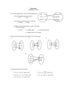
Trigonometry: Worksheet for Test #4
In this trigonometry activity, students determine whether given mappings are functions. They evaluate 5 functions for a given x value. Students graph 2 functions. They determine which ordered pairs are solutions to given functions....
Curated OER
Red October
Fourth graders follow directions given in bearings. They invent their own maps using them and use a protractor to help them with their designs. Students
produce their own maps with instructions for navigating the maps. The channels...
Curated OER
Who's Got Your Power
Students examine and map local sources of energy. They conduct Internet research on their local utility company, identify where their utility company obtains energy, graph the data, and label a map of power plant locations in their state.
Curated OER
Guide Me "Home"
Students find how freedom quilts helped free slaves. In this American History lesson, students read the story Sweet Clara and The Freedom Quilt and discuss the Underground Railroad. They use their map skills to locate...
Curated OER
Algebra/Geometry Institute Summer 2007: Graphing Activity
Seventh graders practice identifying coordinates by examining a city map. For this graphing lesson, 7th graders create coordinate directions on an index card and practice locating these locations on a grid. Students read and...
Curated OER
"Hard" Data from Space
Students use satellite images to analyze development patterns within Baltimore City. They prepare a land cover map for Baltimore indicating the prevalence of impervious surfaces and explore how these patterns affect water pollution.
Curated OER
Biodiversity Memory Match Up
Learners are introduced to the animals of Asia. In this biodiversity lesson, students use interactive maps to identify animals from Asia, then play a memory game to reinforce the information.
Curated OER
Introduction to Archaeology
Students view a PowerPoint presentation called, Archaeological Terms then discuss the job of an archaeologist and new vocabulary. They view the teacher made "artifact grid" and photograph the grid from different angles. They work in...
Curated OER
Arctic Microclimates
Learners identify, measure, and average micro-climatic temperatures in a particular region. They draw a small-scale map of an area to be sampled (classroom, playground, park, backyard) and identify potential locations for...


