Curated OER
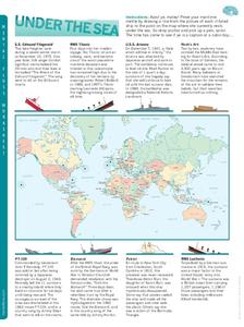
Under the Sea
In this ship wreck activity, students read the information beneath each famous wrecked ship. Students then draw a line from the picture of the ship to the point on the map where it currently rests under the sea..
Curated OER
Our Friends the Trees
Students explore trees and learn about their importance to the environment. In this tree study lesson, students work in groups to complete a tree survey, a map for the survey, and several worksheets about the tree topics. students make a...
Curated OER
Water
Students complete activities to examine the properties of water. In this water science lesson, students read a book about water's forms and study a map or globe of the Earth to investigate water. Students discuss living things that need...
Curated OER
Mayan History
Students examine Mayan contributions to the world. In this Mesoamerican culture lesson plan, students view a slideshow about the Maya and then peruse books about the accomplishments of the culture. Students...
Curated OER
Common/Proper Nouns
Students sort word card into two categories (common and proper nouns). They copy the class charts. Students create a table in Word including the headings, common noun and proper noun. They put the correct words onto their chart and add a...
Curated OER
Language Arts: Reading for Information
Sixth graders discover how to turn book titles into questions in order to locate the information during their reading. Using t-charts, they list titles and subtitles with the questions they suggest. Gradually, 6th graders progress from...
Curated OER
International Phonetic Alphabet
In these alphabet worksheet students will study charts of vowel sounds and their variations. Each vowel gives a list of examples and common words associated with its sound.
Curated OER
You Scratch my Back, I'll Scratch Yours
Students explore the concept of interdependence. In this integrated interdependence lesson, students interpret graphs and charts that require them to analyze the relationship between Mexico and the United States. Students also...
Curated OER
Problem Solving with Multiplication and Division
In this multiplication and division learning exercise, students answer multiplication and division problems where they use charts and solve word problems. Students complete 10 problems total.
Curated OER
Taste Test
Third graders, in groups, complete a science lab in which they perform a blind taste test on eight different foods--some sweet, sour, salty, and bitter. They determine which parts of the tongue "taste" which kinds of foods. they record...
Indian River State College
Argumentative (Persuasive) Essay Guidelines
Here is a handout that outlines six great steps to structuring an argumentative essay, which can be continually referenced as you teach your class about persuasive writing.
New York State Education Department
Global History and Geography Examination: June 2016
Assess scholars' knowledge of the changing borders in Germany during World War II with a test that includes both multiple choice and essay questions.
New York State Education Department
US History and Government Examination: August 2017
Developing a test that uses primary sources to assess class members knowledge of the history of the United States is no easy task! Save yourself the time and stress and use a final exam that includes essay, multiple choice, and short...
Curated OER
Earth Matters
Students identify Earth's equator, prime meridian, lines of latitude, lines of longitude, parallels, and meridians.
Curated OER
Mathematical Diagrams: Networks
In this mathematical diagrams instructional activity, learners solve about 20 short answer diagram problems. Students diagram driving routes, coin weights, and classifying sporting events.
Curated OER
What and Where is Puerto Rico?
Students explore Puerto Rico. They create K-W-L charts of their prior knowledge of Puerto Rico and observe maps of Puerto Rico. They code the map for measurements and land and water forms. They explore websites to gain background on...
Curated OER
From Sea to Shining Sea
Students study the geography of the United States of America. Students write letters, create travel brochures, make maps, graph population numbers, read fiction and nonfiction selections, complete KWL charts, and watch films.
Curated OER
Some Like It Cold
Sixth graders study Canada's northern territories and four settlements above the Arctic Circle. For this northern Canada lesson, 6th graders maps and timelines to locate physical, political, and economic features of northern Canada....
Curated OER
History, Artifacts, and Museums
Eleventh graders interpret historical evidence presented in primary and secondary resources. In this historical artifacts lesson, 11th graders select and research historical topics that require them to interpret calendars, timelines,...
Curated OER
Roller Coaster Mania
Fifth graders extend their knowledge of developing maps. They work in cooperative groups to develop an amusement park display and a brochure.
Curated OER
Kidsville USA
Second graders create an imaginary town using Kid Pix. They demonstrate their knowledge of specific vocabulary words and their knowledge and understanding of location by placing schools, stores, parks, etc. appropriately on their maps.
Curated OER
The Geography of Maine Tourism
Students study topographical maps of Maine to identify the important physical features. They work in groups to create tourism pamphlet highlighting a region of the state.
Curated OER
Neighborhood Appreciation
Fifth graders examine the neighborhoods around their school. Using maps, they document landmark buildings and community organizations with digital cameras. They write about their journeys and share them with the community.
Curated OER
What is an Explorer
Students become explorers. They examine a picture of an explorer and create props to explore within the classroom. Students are studying the Louisiana Purchase of 1803. They explore how to read a map and create a map of the classroom...
Other popular searches
- Analyze Maps and Charts
- Reading Maps and Charts
- Charts and Maps
- Ireland Maps and Charts
- Tables, Maps and Charts
- Maps, Charts, Globes
- Graphs Charts and Maps
- Interpreting Charts and Maps
- Tables Maps and Charts
- Graphs, Charts and Maps
- Graphs\, Charts and Maps
- Charts, Graphs, Maps
